The Impact of Recreational Activities on Aquatic Vegetation in Alpine Lakes


1
Department of Botany and Nature Protection, University of Warmia and Mazury in Olsztyn, Plac Łódzki 1, 10-727 Olsztyn, Poland
2
Institute of Geography and Land Management, University of Warmia and Mazury in Olsztyn; Prawocheńskiego Str. 15, 10-720 Olsztyn, Poland
3
Department of Fish Biology and Pisci Culture, University of Warmia and Mazury in Olsztyn, Oczapowskiego Str. 5, 10-719 Olsztyn, Poland
*
Author to whom correspondence should be addressed.
Water 2019, 11(1), 173; https://doi.org/10.3390/w11010173
Submission received: 6 December 2018
/
Revised: 9 January 2019
/
Accepted: 14 January 2019
/
Published: 18 January 2019
(This article belongs to the Section Water Quality and Contamination)
Abstract
:Tourism pressure on protected areas with attractive landscapes leads to environmental modifications. Eutrophication poses the main threat to the quality of water in alpine lakes. Even small inflows of biogenic elements can disrupt the ecological balance of these ecosystems. The aim of this study was to verify the hypothesis that recreational activities and easy access to alpine lakes contribute to changes in their ecological status. This hypothesis was verified by analyzing the presence of hydromacrophytes in two lakes of the Tatra National Park (Poland). The analysis was carried out along segments of hiking trails which were evaluated for accessibility to the studied lakes. Underwater surveys were carried out during scuba diving expeditions in 2012–2016. Submerged vegetation was evaluated in both lakes. This is the first study in Poland and one of the few projects in the world to have relied on such extensive support from scuba divers to generate highly accurate measurements. The study demonstrated that lake bottoms were extensively covered by Potamogeton friesii in the vicinity of trail segments with easy access to lakes. Our results show that tourism pressure contributes to the growth of aquatic vegetation in some areas of alpine lakes. We relied on our findings to propose several modifications to the routes of the evaluated tourist trails to minimize the impact of anthropogenic pressure on the studied lakes.
1. Introduction
The term “alpine lakes” applies not only to the lakes situated in the Alps or the Apennines, but it covers a broader category of water bodies with specific geomorphological and biological parameters. Alpine lakes are water bodies that are situated at high altitudes (lakes characteristic of montane regions) and are relatively small, cold, oligotrophic, dilute and colonized by sparse flora and fauna [1,2,3]. Submerged, semi-submerged and littoral (hygrophilous peri-lacustrine) vegetation is not commonly encountered in alpine lakes. The high ecological status of alpine lakes is generally characterized by average depth limit of vegetation at around 10 m [2]. Sedges, rushes and horsetails grow around lake shores due to nutrient enrichment in the littoral zone. Emergent plants, such as Sparganium angustifolium and Ranunculus aquatilis, are also encountered in alpine lakes [3,4,5,6].
The Tatras are a macroregion of the Western Carpathians and the tallest mountain range in the Carpathian Mountains. They occupy an area of 785 km2, of which more than 77% lies in Slovakia and less than 23% in Poland. The Tatras are the only alpine region in Poland [7]. In 1954, the entire Polish part of the Tatras was granted the status of a national park (the highest level of nature protection in Poland) under the name of the Tatra National Park (TNP). In 1992, the UNESCO designated the Polish and Slovakian Tatra National Parks as International Biosphere Reserves [7]. Surface waters occupy less than 1% of the area of the Polish TNP. They include lakes (28 out of more than 100 variously sized natural water bodies have an area larger than 1 ha), perennial streams (with a total length of 175 km) and intermittent streams (with a total length of 147 km) [8]. Due to their origin, most lakes are situated at altitudes higher than 1600 m, in particular in the High Tatras. The majority of these water bodies are glacial lakes, and glacial retreat induced far greater landform transformations in the High Tatras than in the Western Tatras. Most lakes are tarns that fill glacial cirques, including Czarny Staw pod Rysami and Kolisty Staw. Moraine lakes are usually smaller and shallower. They were formed in depressions dammed by lateral moraines (Smreczyński Staw) and terminal moraines (Toporowy Staw Niżni). Morskie Oko and Czarny Staw Gąsienicowy have the combined features of tarns and moraine lakes. They occupy strongly eroded glacial valleys and are dammed by rock lips with accumulated terminal moraine debris. The Polish TNP also features kettles which are were formed by blocks of ice calving from glaciers. Examples of the above include the large Lake Szczyrbskie and the small Kotlinowy Stawek pond. Small ponds, such as Dwoisty Staw Gąsienicowy and Anusine Oczko, fill depressions between accumulated boulders and scree deposits, and many of them have mixed origin. Medium-sized ponds, such as Stawy Rohackie, Wyżnie Mnichowe Stawki and Zmarzłe Oka, occupy troughs between rôche moutonnée formations created by the passing of a glacier. Most lakes in the Tatras have highly transparent water (10–20 m, depending on the lake) due to low levels of organic life, the absence of plankton and minimal sedimentation [9,10,11]. The littoral is absent or poorly developed. Bottom sediments are strongly mineralized and deficient in organic compounds, in particular nitrogen compounds. The above is also responsible for the quantitative deficiency of plankton in Tatra lakes. Lakes localized in the Tatra Mountains are cold (depending on the elevation of the lake surface above sea level; in summer, water temperature ranges from 5 °C to 14 °C) and highly oxygenated. They are classified as ultra-oligotrophic lakes [9].
The Tatra Mountains and their lakes are exposed to various types of anthropogenic pressure [10,11]. The adverse consequences of these changes can be mitigated by monitoring the status of the environment and forecasting potential threats, in particular the expansion of foreign species [12,13,14,15]. Tourism pressure on nature conservation areas continues to increase due to attractive scenery and high levels of biodiversity in those regions. Conflict is inevitable as the growing popularity of recreational areas increases tourist traffic and significantly contributes to environmental transformation and degradation [16,17,18,19,20,21,22].
Eutrophication poses one of the greatest threats to the quality of inland and coastal waters [20,23,24,25]. This problem has been recognized by the European Union law, and many EU directives have placed the Member States under an obligation to monitor eutrophication levels in surface water and implement preventive and mitigating measures (e.g., Council Directive 91/271/EEC, Council Directive 91/676/EEC, Council Directive 2000/60/EC). The Polish Water Law (2017) and the EU directives define eutrophication as the undesirable effects of human activities resulting from the enrichment of water by biogenic elements (in particular nitrogen and phosphorus compounds). Wastewater, fertilizer runoff, soil erosion, air pollution, animal manure and industrial waste are the main anthropogenic sources of biogenic elements [20,26,27,28,29,30,31]. High nutrient concentrations in water bodies stimulate the growth of algae and vascular plants which use up dissolved oxygen and decrease the amount of light reaching deeper areas [20,32]. Montane regions are generally devoid of industrial sites. However, the development of tourist facilities and growing levels of tourist traffic can exacerbate the adverse effects of anthropogenic pressure on alpine ecosystems.
Lakes Morskie Oko and Czarny Staw pod Rysami are among the greatest tourist attractions in the TNP. They are national symbols with sentimental value for Polish tourists, and they have a similar appeal as alpine lakes for foreign visitors. The lakes selected for the study are characterized by very high levels of tourist traffic, in particular in the area of Lake Morskie Oko. The trail leading to Lake Morskie Oko is one of the most popular tourist routes in the country which is accessible to less experienced hikers. Tourists can reach the lake by hiking up a gently inclined paved road (around 8.5 km) or riding horse-drawn carriages. According to TNP data regarding ticket sales in 2013–2017 [33], tourist traffic has continued to increase in the analyzed area (Table 1). Tourist traffic is highest in August, and the data for that month were analyzed. The number of visitors entering the evaluated trail accounted for more than 30% of the combined entrances to all hiking trails in the TNP. A comparison with ticket sales data for August 2004 and August 2009 revealed a significant increase in tourist traffic. In August 2004 and August 2009, the number of visitors entering the evaluated trail accounted for 25.9% and 26.7% of the total traffic in the TNP, respectively [34].
Lake Czarny Staw pod Rysami attracts far less traffic due to its location and more difficult access. Many tourists pass the lake on the trail leading to Rysy, Poland’s tallest mountain (2499 m a.s.l.), or Przełęcz pod Chłopkiem (2307 m a.s.l.). These tourists have greater hiking experience and are generally characterized by higher levels of environmental awareness than those who visit Lake Morskie Oko [35,36].
The direct consequences of tourism on alpine lakes, including the lakes in the TNP, have not been thoroughly investigated and require in-depth research [11,20].
Assessments of the ecological status of water bodies should account for all biological quality elements and the associated physico-chemical and hydromorphological elements. The biological elements that are most susceptible to eutrophication include planktonic algae (phytoplankton), phytobenthos (mostly diatoms) and which respond most rapidly to nutrient enrichment, as well as macrophytes (emergent, submersed and floating-leaved aquatic plants) and zooplankton which respond somewhat slower to change. Phytoplankton and phytobenthos take up nutrients directly from the water, which is why they are early indicators of eutrophication [37]. However, phytoplankton is characterized by considerable seasonal variation, and environmental assessments based on these indicators may be difficult to perform. Macrophytes take up nutrients from bottom deposits and, in some cases, from the water. The species diversity, structure and cover density of macrophytes change at the community level in response to water nutrients [38]. A reduction in the colonization depth of aquatic plants and the loss of selected macrophyte communities, such as Chara, due to lower availability of light (caused by rapidly developing phytoplankton) are reliable indicators of eutrophication [1,24,39,40]. Macrophytes respond to nutrient enrichment at a much slower rate than phytoplankton, and they are not early indicators of eutrophication. However, macrophyte communities are more stable; therefore, they are better predictors of long-term changes [41]. Therefore, a combination of methods involving elements that respond rapidly and slowly to eutrophication is needed to reliably assess the severity of eutrophication [2,39,42]. Macrophyte-based assessments of the ecological status of lakes are increasingly often performed with the support of scuba divers. According to the literature, scuba diving is the most reliable and least invasive (practically non-invasive) method of research in comparison with traditional methods that rely on anchors and dredges [39,41,43,44,45].
The hydromacrophyte communities of the Tatra National Park have been scantily researched. The existing publications describe the flora of lakes Morskie Oko and Wielki Staw Polski [46,47], Potamogeton friesii Rupr. in Lake Morskie Oko [48] and Batrachium trichophyllum (Chaix) Bosch in Lake Mały Staw Polski [49]. These species are most characteristic of mesotrophic and eutrophic lakes, but they also colonize alpine lakes [2,50,51,52,53]. Plant communities with a predominance of Potamogeton sp. and Ranunculus trichophyllus typically grow in the littoral zone of lakes in the upper subalpine and/or lower alpine limit of siliceous mountains [5]. Flat-stalked pondweed is not listed in the Distribution Atlas of Vascular Plants in Poland [54]. Further research is needed to address this topic.
The following research hypothesis was postulated: Tourism and easy access to alpine lakes contribute to changes in the lakes’ ecological status (increased presence of hydromacrophytes). The hypothesis was verified by analyzing the presence of hydromacrophytes in two alpine lakes in the Tatra National Park—Morskie Oko (32.78 ha) and Czarny Staw pod Rysami (20.28 ha)—in relation to access to the lake surface (tourism pressure).
This is the first study in Poland and one of the few projects in the world to have relied on such extensive support from scuba divers to generate highly accurate measurements. The results of the study and the formulated conclusions can be used to develop conservation recommendations and to plan tourism in the Tatra Mountains as regards tourism carrying capacity, land development and the course of tourist trails (see: Practical recommendations).
2. Materials and Methods
2.1. Description of the Studied Area
Two lakes in the Tatra National Park were studied—Morskie Oko and Czarny Staw pod Rysami (Figure 1 and Figure 2). Morskie Oko has an area of 34.39 ha and shoreline length of 2539 m (own measurements), and it is the largest lake in the Tatra Mountains. This glacial lake is situated in the valley of Dolina Rybiego Potoku at an altitude of 1395 m a.s.l., and it has a maximum depth of 50.8 m.
Czarny Staw pod Rysami has an area of 20.64 ha and shoreline length of 1762 m (own measurements), and it is situated on the hiking trail that surrounds Morskie Oko. Czarny Staw pod Rysami has a maximum depth of 76.4 m, and it is situated at an altitude of 1580 m a.s.l. [55]. Both lakes are fed mainly by precipitation and, directly and indirectly, by surface and rock runoffs. Melting snow and ice significantly contribute to water supply in the analyzed lakes. The lakes are situated in an area with one of the highest annual precipitation rates in Poland. Their unique features contribute to high water transparency, which is determined at 23.0 m in Czarny Staw pod Rysami and 15 m in Morskie Oko [11]. In summer, the temperature of the lake surface fluctuates from 9.4 °C to 21.5 °C in Morskie Oko and from 7 °C to 11.5 °C in Czarny Staw pod Rysami [9]. Morskie Oko and Czarny Staw pod Rysami are characterized by low levels of organic life, strong mineralization and deficiency of organic compounds, in particular nitrogen compounds, in the bottom deposits [9,11,20]. They are classified as ultra-oligotrophic lakes where even small inflows of biogenic substances can lead to irreversible changes in the ecological balance [56].
2.2. Field Study
Lakes Morskie Oko and Czarny Staw pod Rysami were evaluated with the involvement of scuba divers during underwater observations carried out on: 22–26 September 2012, 23–25 September 2013, 9–11 September 2015, and 23–25 September 2016. Lake bottoms were explored by a total of nine teams with two licensed scuba divers per team (PEK1—Diver Ecologist Level I, PEK2—Advanced Diver Ecologist Level II and MEK—Ecologist Diver Instructor). Every diving session lasted up to 2 h. During each diving session, the divers’ position was monitored by two researchers in a boat, and divers described the encountered vegetation on special plates with tables containing fields where species names, coverage area, proportion of each species and depth of occurrence were entered. At the same time, the location of the identified site was determined with the use of a Garmin GPS receiver (waypoints, to specify geographic coordinates), and the relevant information was communicated to team members on the surface. A total of 155 localities were described in Lake Morskie Oko. The lake bottom was explored within the boundaries of the phytolittoral zone (Morskie Oko—13 m, Czarny Staw pod Rysami—25 m).
During the evaluation, the shores of both lakes were additionally examined to determine the intensity of tourism pressure (trampled paths, lake access points, accummulation of waste left behind by tourists, including off the main trail and under water, damaged undergrowth, broken tree and shrub branches). The geographic coordinates of the inspected areas were determined and analyzed with ArcGIS 10.5 software (ESRI Inc., Redlands, CA, USA). The evaluated tourist sites were assigned attributes, as well as point, linear and surface layers, subject to need and the type of the observed phenomena. The above approach facilitated spatial analyses (with the use of the available ArcGIS tools) of the intensity of anthropogenic pressure in different segments of tourist trails and the concentration of hydromacrophytes in each lake. The results of spatial analyses were used to verify the research hypotheses.
2.3. Evaluation of the Degree of Anthropogenic Pressure
The level of anthropogenic pressure was assessed based on an indicator related to the presence of submerged plants (filamentous algae, bryophytes and vascular plants) found in the buffer zone of 100 m from the trail. The tourist trail was divided into 100-m-long segments—25 segments in the area of Morskie Oko and 12 segments in the area of Czarny Staw pod Rysami. The impact of tourist traffic was evaluated in the buffer zone of 100 m from the trail, and the size of the buffer zone was adopted based on the fact that plants were encountered at a distance of up to 100 m from the analyzed trail.
Four parameters of lake accessibility were described, and their influence was determined with the use of weights (Table 2). The values given in the tables account for the local landform and tourism pressure. The parameters described the difficulty of access to the studied lakes and, consequently, the lake’s relative exposure to anthropogenic impacts from the trails. The evaluated parameters were: Distance from the lake surface, average trail height above the lake surface, presence of trees and shrubs obstructing access to the lake, presence of boulders and steep rock surfaces. Weights were assigned on a three-point scale to describe the lake accessibility:
- (1)
- 1—very difficult or impossible access,
- (2)
- 2—difficult access,
- (3)
- 3—minor obstacles or easy access.
The sum of the weights describing lake accessibility in every segment of the analyzed trail was divided into accessibility classes—KD. The weights were divided at equal intervals, because parameters could have identical weights. The following accessibility classes were determined:
- Accessibility class I—minor obstacles or easy access—(10–12),
- Accessibility class II—difficult access—(7–9),
- Accessibility class III—very difficult or impossible access—(4–6).
The area covered by the identified types of vegetation was described with the use of plant cover classes, KP, based on the Jenks natural breaks classification method [57]. In this approach, similar values are grouped (to reduce the variance within classes) and maximize the variance between classes. ArcGIS software features a tool for classifying data with the use of the natural breaks classification method. This method is useful for analyzing unevenly distributed data, and it is applied to visualize large datasets in environmental and socioeconomic studies [58,59,60,61,62]. The natural breaks classification method was applied because the analyzed data had an uneven distribution. Lake bottoms covered by submerged vegetation were divided by buffer zones of 100 m each, which corresponded to the segments of the analyzed tourist trail. Due to a large number of segments, as well as a large number of similarly-sized areas of submerged vegetation, three plant cover classes (KP) were identified:
- Cover class I—(856 m2–5213 m2).
- Cover class II—(258 m2–855 m2).
- Cover class III—(0 m2–257 m2).
In addition to the parameters presented in Table 2 and the resulting accessibility classes (KD) and plant cover classes (KP), the number of lake access points in direct proximity to the trail was also determined. Easier access to lakes intensifies anthropogenic pressure and pollution with organic and inorganic waste. Areas belonging to accessibility class I (KD) create the most favorable conditions for the growth of submerged vegetation, and they correspond to plant cover class I (KP). Accessibility classes II and III correspond to cover classes II and III.
3. Results and Discussion
The described underwater surveys revealed the presence of plants only in Morskie Oko. Vegetation was present in 21 trail segments and absent in only 4 segments (Figure 3, Figure 4 and Figure 5). Lake Morskie Oko was colonized by only one species of vascular plants—Potamogeton friesii Rupr., and three species of aquatic mosses—Blindia acuta (Hedw.) Bruch and Schimp, Palustriella comutata (Hedw.) Ochyra and Hygrohypnum luridum (Hedw.) Jenn. These species occurred sporadically and covered only small areas. To verify the research hypothesis, the identified species were jointly regarded as hydromacrophytes, and the areas occupied by these species were marked on maps (Figure 3, Figure 5 and Figure 6). The largest areas colonized by macrophytes in 100-m buffers from the trail were found along the south-eastern shore of Morskie Oko. Along the northern and eastern shores, hydromacrophytes formed isolated islands on the bottom of the lake. Hydromacrophytes covered the smallest areas along the south-western shore of the lake (Figure 6). The published data on aquatic vegetation in alpine lakes indicate that submerged, semi-submerged and shore (hygrophilous peri-lacustrine) vascular plants can colonize alpine lakes where accumulating sediments produce a sandy-silty bottom layer with organic debris. According to the Alpine Macrophyte Geographical Intercalibration Group (2014), hydromacrophyte communities in alpine lakes usually build more or less dense stands dominated by sensitive taxa, mostly Charaphytes (e.g., Chara hispida, Chara aspera, Chara tomentosa, Chara strigosa, Chara connivens, Chara virgata, Chara globularis, Chara intermediata, Chara ploycantha) [2]. The examined ecosystems (alpine lakes) are also characterized by high ecological sensitivity, and even small inflows of biogenic elements from the catchment can disrupt the ecological balance [56]. Several species of the genus Potamogeton can be found among submerged and semi-submerged plants in mountain lakes. The species of the genus Potamogeton, including Potamogeton alpinus, P. filiformis, P. gramineus, P. rutilus, P. trichoides and Potamogeton x angustifolius, are regarded as the reference indicators for alpine lakes. Depending on the depth of occurrence, Potamogeton friesii is regarded as an indicator of lake degradation (0–1 m and 1–2 m) or a taxon that is indifferent to changes in lake trophy (2–4 m and deeper than 4 m) [2]. The development of Potamogeton friesii Rupr. was most abundant at a depth of 0.7–2 m within a 100 m radius from the sites in trails that were intensively visited by tourists. Despite an explicit ban on trash dumping, tourists leave behind organic waste (sandwiches, food remnants, drink bottles, cosmetics, feces) in these areas, which leads to water enrichment with biogenic elements and can contribute to the development of vegetation.
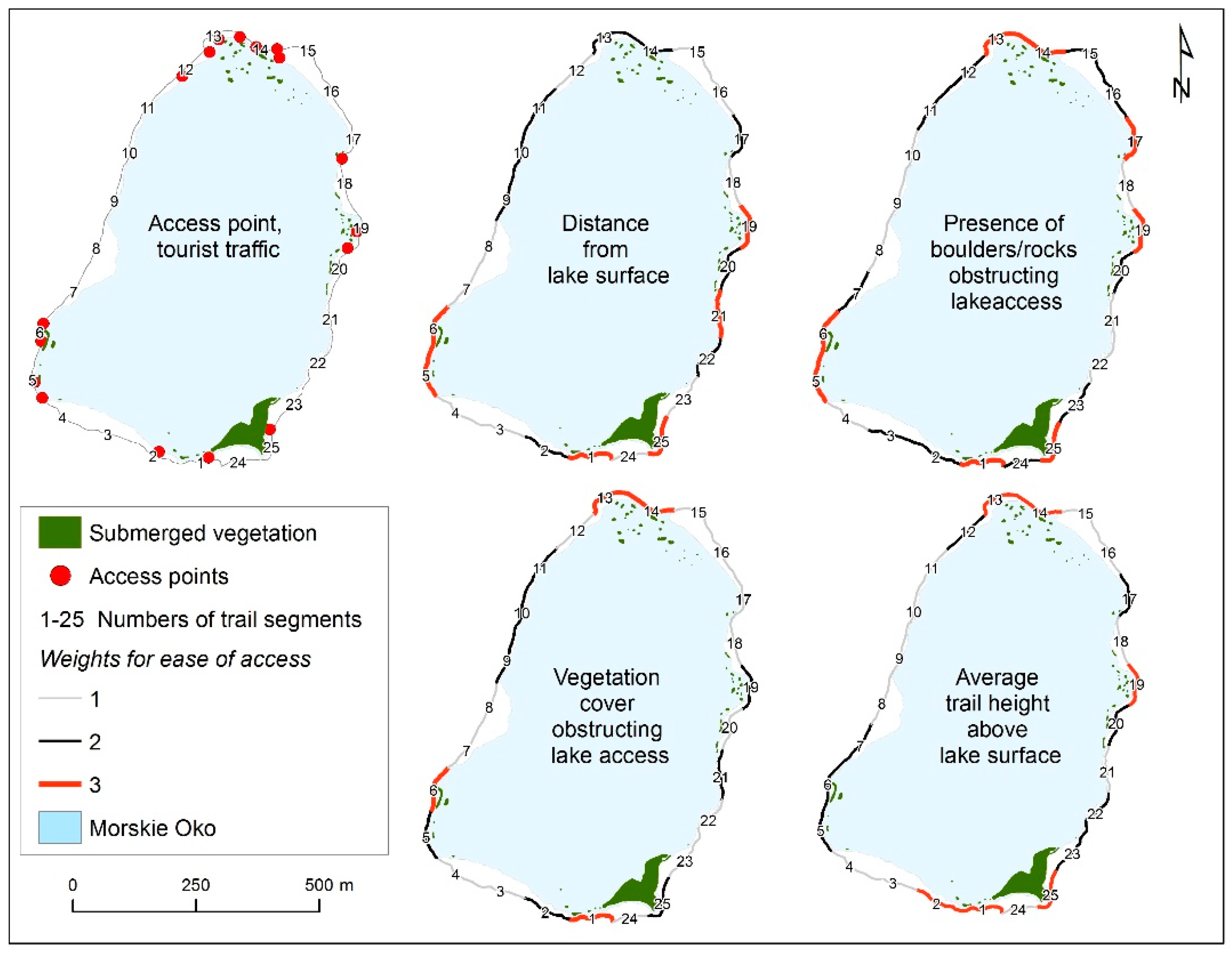
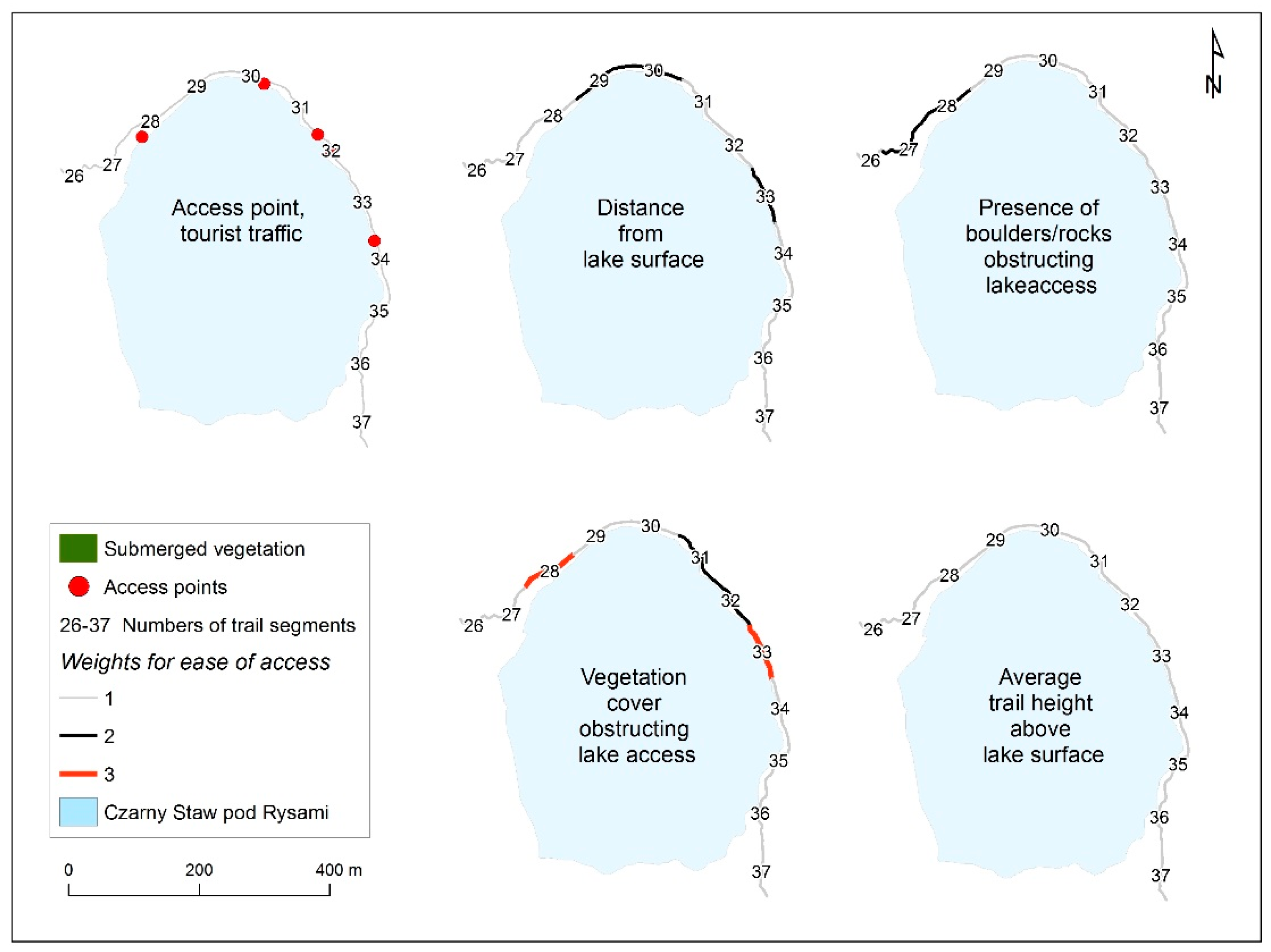
The weights of each parameter (Table 2) describing accessibility to each of the analyzed lakes are presented graphically in Figure 3 (Morskie Oko) and Figure 4 (Czarny Staw pod Rysami). The analysis of accessibility classes KD, identified with the use of the described methods based on the sum of weights assigned to the analyzed parameters (Table 3), show that in case of Morskie Okao, 6 trail segments were characterized by considerable ease of access to the lake—class III, 11 trail segments were characterized by difficult access to the lake—class II, 8 trail segments were characterized by very difficult or impossible access to the lake—class I (Figure 5). In case of Czarny Staw pod Rysami, 10 trail segments were included in accessibility class I, and 2 trail segments—in accessibility class II (Figure 5). The analysis of plant cover classes (KP) parameter in Morskie Oko show 8 trail segments were characterized by class I, 13 trail segments were characterized by class II and 4 trail segments were characterized by class III (Figure 6). In Czarny Staw pod Rysami, all trail segents were chaeacterized by plant cover class I (Figure 6).
In the case of Morskie Oko trail segments no. 1 and no. 25 (characterized by considerable ease of access to the lake) were included in plant cover class III (Figure 5 and Figure 6). Vegetation was also present in segments no. 23 and no. 24 despite difficult access to the lake (Figure 6). The above could be attributed to the immediate vicinity of segment no. 25 which splits into trails, one of which leads to Lake Czarny Staw pod Rysami. This segment of the trail is characterized by high tourist traffic. Segments no. 13 and no. 19 also have easy access to the lake (Figure 5), where segment no. 13 (similarly to segments no. 12, 14 and 15) is located in the direct vicinity of a large mountain lodge which serves thousands of tourists daily in summer. Despite heavy tourist traffic and the presence of five access points, the area surrounding the lodge was included in plant cover class II (Figure 3, Figure 5 and Figure 6). The above could be explained by the presence of tourist facilities which act as a protective buffer. Tourist facilities are not available on the opposite side of the lake (segments no. 1, 23, 24 and 25). Trail segments characterized by very difficult access to the lake (class III) were assigned to all three plant cover categories (Figure 5 and Figure 6). Access points played an important role in this stage of the analysis. Most of them were located in areas with easy access to the lake, and only three points had very difficult access (Figure 3).
The bottom of Lake Czarny Staw pod Rysami was completely devoid of vegetation (Figure 6). The above can be attributed to the fact that the lake is much more difficult to access from the hiking trail (Figure 5). The trail to the Lake Czarny Staw pod Rysami requires greater hiking expertise, which contributes to lower tourist traffic. It should also be noted that the lake is situated 188 m above Lake Morskie Oko; therefore, it offers less supportive conditions for vegetation growth.
In view of the assumptions adopted for the needs of the research, accessibility class I should correspond to plant cover class I, accessibility class II—to cover class II, and accessibility class III—to cover class III. The results of the measurements performed in different segments of the trail to determine accessibility to the studied lakes, accessibility classes (KD) and plant cover classes (KP) are presented in Table 3. The number of access points in the analyzed trail segments and the degree of correspondence between accessibility class (KD) and plant cover class (KP) are also presented in Table 3, where full correspondence is denoted by “+”, absence of correspondence in two classes—by “−”, and absence of correspondence in one class—by “+/−”. The degree of correspondence between the classes is presented in Table 4 based on the data from the last column of Table 3. A high degree of correspondence was observed in Lake Morskie Oko, and an absence of correspondence in two categories was noted only in two trail segments (23 and 24). In summer, the analyzed area is visited by up to 20,000 tourists per day; therefore, anthropogenic pressure is likely to be high even in locations with a difficult access to the lake. The degree of correspondence was very high in Lake Czarny Staw pod Rysami, and an absence of correspondence in one class was noted in only two cases. The lake is very difficult or impossible to access from nearly every point on the trail, which offers effective protection against anthropogenic pressure. As mentioned earlier, tourists who reach Lake Czarny Staw pod Rysami are generally more experienced hikers with higher levels of environmental awareness, which is an additional protective factor. Tourist behaviors, including failure to observe the rules and regulations in protected nature sites around the world and the resulting consequences for the natural environment, have also been discussed by other authors [63,64,65,66,67,68].
According to the literature, the impact of anthropogenic pressure on water bodies in the Tatra National Park is not a new research topic and has been studied previously e.g., [11,20,69]. The cited studies analyzed e.g., the composition of lake water and compared their findings with the relevant data from earlier years [11], or investigated the composition of sediment cores to examine the recent environmental history of alpine lakes in the Polish part of the Tatra Mountains [20,61]. The results of the cited analyses indicate, among others, that the content of biogenic elements (mainly nitrogen and phosphorus compounds) in the studied lakes has increased [11,20,70,71]. Our study demonstrated that the species regarded as indicators of degradation in alpine lakes [2] were present in the analyzed water body. This fact could be attributed to long-term supply of biogenic elements, including due to heavy tourist traffic in hiking trails and sites used as points of access to the lakes, and the scattering of organic waste, such as sandwiches, food remnants, drink bottles, cosmetics and feces.
The problems associated with strong tourist-induced pressure on lakes have also been discussed by other researchers, including in the mountainous regions of the Iberian Peninsula and the Swiss Alps [72,73,74]. Therefore, the pressure from growing tourism poses not only a local (encountered in Poland), but a global problem.
4. Practical Recommendations
The changes recommended by the authors in the route of the hiking trail in the analyzed area are presented in Figure 7. Alternative routes were mapped to minimize anthropogenic pressure by moving tourists away from lake shores. Barriers and banisters were designed on the trail surrounding Lake Morskie Oko to channel tourist traffic along the northern (from the wooden footbridge on the Rybi Potok stream), western and southern shores (from the trail to Lake Czarny Staw pod Rysami). The attempts to channel tourist traffic were also made to obstruct or block access to the lake. We have proposed the complete closure of the eastern part of the trail between the wooden footbridge on the Rybi Potok stream and the trail to the second lake. In our opinion, the closure of the eastern part of the trail leading from the stone steps of the Morskie Oko lodge is practically impossible due to heavy tourist traffic. The solutions proposed in our study would decrease traffic in the most heavily traveled segment of the trail where tourism contributes most to the supply of biogenic elements to lake water and increases the cover of submerged vegetation. The solutions recommended in our study, including changes in the route of hiking trails, partial trail closure and traffic restrictions in the immediate vicinity of the analyzed lakes, are partially consistent with the changes proposed by other authors [56,75]. Published data and the results of our research indicate that the complete elimination of access to the lake shores in the vicinity of the mountain lodge has been a priority for many years. The area surrounding the lodge is characterized by the highest tourist traffic. Other recreational options (thematic trails, information boards, exhibitions) could be developed for less advanced hikers. According to the suggestions made by other researchers [51,70], the trail on the western shore of Lake Morskie Oko should be joined with the trail leading to Szpiglasowa Przełęcz (number 5 in Figure 2), and a new connection to the trail leading to Lake Czarny Staw pod Rysami should be built. This solution would expand the protective zone around Lake Morskie Oko.
In the solution proposed in our study for Lake Czarny Staw pod Rysami, tourist traffic would be reduced by building barriers and banisters only along the north-eastern shore of the lake which is the most heavily traveled segment of the trail and is closest to the trail to Morskie Oko. The remaining parts of the trail do not require modifications due to relatively difficult lake access and lower traffic in comparison with Morskie Oko. The absence of pollution and submerged vegetation also point to low threat of anthropogenic pressure.
5. Conclusions
Easy access to lakes contributes to the spread of macrophytes in the analyzed buffer zones, possibly due to the presence of biogenic elements that reach lake water with the waste, including feces, left behind by tourists.
Morskie Oko is an alpine lake that is highly deficient in organic matter. Nutrients are practically not available for aquatic organisms, organic matter decomposes very slowly and it is naturally expected to be nearly completely used up by plants in the location where it was introduced to the lake. The above could lead to high plant density in areas that are directly supplied with biogenic elements. Unlike Morskie Oko, Lake Czarny Staw pod Rysami is completely devoid of vegetation. The lake is characterized by very low levels of pollution, as well as considerable altitude, which minimizes the threats associated with anthropogenic pressure.
The results of the study can be used to formulate several conclusions regarding environmental management in the analyzed area. Tourists have very limited access to Lake Czarny Staw pod Rysami, which minimizes the relevant environmental threats. Lake Morskie Oko is much easier to access from the hiking trail; therefore, visitors are much more likely to contribute to anthropogenic pressure. Our findings were used to propose several recommendations to minimize the negative impact of high tourist traffic. The route of the trail should be modified in line with the proposed recommendations, and direct access to the lake should be blocked. The mountain lodge in Morskie Oko should be modernized and equipped with suitable facilities for handling high levels of tourist traffic. These measures could prevent adverse changes in biotic and abiotic elements and contribute to the gradual restoration of natural resources in the analyzed area.
Author Contributions
Conceptualization, P.D., A.S., A.Ź.-S., J.K.; Data curation, P.D., A.Ź.-S.; Investigation, P.D., A.Ź.-S.; Methodology, A.S.; Validation, A.S.; Visualization, P.D.; Writing—original draft, P.D., A.S., A.Ź.-S.; Writing—review and editing, P.D., A.S.
Funding
This research received no external funding.
Conflicts of Interest
The authors declare no conflict of interest.
References
- Catalan, J.; Grazia Barbieri, M.; Bartumeus, F.; Bitusik, P.; Botev, I.; Brancelj, A.; Cogalniceanu, D.; Manca, M.; Marchetto, A.; Ognjanova-Rumenova, N.; et al. Ecological thresholds in European alpine lakes. Freshw. Biol. 2009, 54, 2494–2517. [Google Scholar] [CrossRef] [Green Version]
- Pall, K.; Bertrin, V.; Buzzi, F.; Boutry, S.; Dutartre, A.; Germ, M.; Oggioni, A.; Schaumburg, J.; Urbanič, G. Water Framework Directive Intercalibration Technical Report. Alpine Lake Macrophyte Ecological Assessment Methods; Poikane, S., Ed.; Publications Office of the European Union, EU: Luxembourg, 2014; pp. 1–128. ISBN 978-92-79-35462-5. [Google Scholar]
- Raut, R.; Sharma, S.; Bajracharya, R.M. Biotic response to acidification of lakes—A review. Kathmandu Univ. J. Sci. Eng. Technol. 2012, 1, 171–184. [Google Scholar] [CrossRef]
- Melzer, A. Aquatic macrophytes as tools for lake management. In The Ecological Bases for Lake and Reservoir Management. Developments in Hydrobiology; Harper, D.M., Brierley, B., Ferguson, A.J.D., Phillips, G., Eds.; Springer: Dordrecht, The Netherlands, 1999; Volume 136, pp. 181–190, ISBN 978-94-017-3282-6, ISBN 978-90-481-5251-3. [Google Scholar]
- Cantonati, M. Flora. In High-Altitude Lakes. Pearls in the Mountain Landscape; Stoch, F., Ed.; Museo Friulano di Storia Naturale: Udine, Italy, 2006; pp. 45–66. ISBN 88 88192 28 X. [Google Scholar]
- Rey-Boissezon, A.; Auderset Joye, D. Habitat requirements of charophytes—Evidence of species discrimination through distribution analysis. Aquat. Bot. 2015, 120, 84–91. [Google Scholar] [CrossRef]
- Błażejczyk, A. Some problems of tourist activity in the Tatra National Park. In Monitoring and Management of Visitor Flows in Recreational and Protected Areas: Conference Proceedings. Proceedings of the Monitoring and Management of Visitor Flows in Recreational and Protected Areas, Vienna, Austria, 30 January–2 February 2002; Arnberger, A., Brandenburg, C., Muhar, A., Eds.; Bodenkultur University: Vienna, Austria, 2002; pp. 417–420. [Google Scholar]
- Kot, M. The Life of the Tatras Waters; Wydawnictwo Tarzańskiego Parku Narodowego: Zakopane, Poland, 2009; ISBN 978-83-60556-80-1. [Google Scholar]
- Szafer, W. (Ed.) Tatrzański Park Narodowy (Tatra National Park); Zakład Ochrony Przyrody, PAN: Kraków, Poland, 1962; pp. 1–675. (In Polish) [Google Scholar]
- Radwańska-Paryska, Z.; Paryski, W.H. Wielka Encyklopedia Tatrzańska (Great Tatra Encyclopedia); Wydawnictwo Górskie: Poronin, Poland, 2004; pp. 1–699. ISBN 83-7104-009-1. (In Polish) [Google Scholar]
- Kurzyca, I.; Choiński, A.; Kaniecki, A.; Siepak, J. Water ecosystems affected by human impact within the protected area of the Tatra National Park (Poland). Oceanol. Hydrobiol. Stud. 2009, 38, 77–86. [Google Scholar] [CrossRef] [Green Version]
- Bazzichetto, M.; Malavasi, M.; Barták, V.; Rosario Acosta, A.T.; Moudrý, V.; Carranza, M.L. Modeling plant invasion on Mediterranean coastal landscapes: An integrative approach using remotely sensed data. Landsc. Urban Plan. 2018, 171, 98–106. [Google Scholar] [CrossRef]
- Hulme, P.E. Trade, transport and trouble: Managing invasive species pathways in an era of globalization. J. Appl. Ecol. 2009, 46, 10–18. [Google Scholar] [CrossRef]
- Łoboda, A.M.; Bialik, R.J.; Karpiński, M.; Przyborowski, Ł. Two simultaneously occurring Potamogeton species: Similarities and differences in seasonal changes of biomechanical properties. Pol. J. Environ. Stud. 2019, 28, 1–16. [Google Scholar] [CrossRef]
- Robionek, A.; Banaś, K.; Chmara, R.; Szmeja, J. The avoidance strategy of environmental constraints by an aquatic plant Potamogeton alpinus in running waters. Ecol. Evol. 2015, 5, 3327–3337. [Google Scholar] [CrossRef]
- Tomczyk, A.M.; Ewertowski, M.W.; White, P.C.L.; Kasprzak, L. A new framework for prioritising decisions on recreational trail management. Landsc. Urban Plan. 2017, 167, 1–13. [Google Scholar] [CrossRef]
- Monz, C.A.; Pickering, C.M.; Hadwen, W.L. Recent advances in recreation ecology and the implications of different relationships between recreation use ecological impacts. Front. Ecol. Environ. 2013, 11, 441–446. [Google Scholar] [CrossRef]
- Adamowicz, W.; Naidoo, R.; Nelson, E.; Polasky, S.; Zhang, J. Nature-based tourism and recreation. In Natural Capital: Theory and Practice of Mapping Ecosystem Services; Kareiva, P., Tallis, H., Ricketts, T.H., Daily, G.C., Polasky, S., Eds.; Oxford University Press: Oxford, UK, 2011; pp. 188–205. ISBN-13: 978-0199589005, ISBN-10: 0199589003. [Google Scholar] [CrossRef]
- Smith, V.H.; Schindler, D.W. Eutrophication science: Where do we go from here? Trends Ecol. Evol. 2009, 24, 201–207. [Google Scholar] [CrossRef] [PubMed]
- Sienkiewicz, E.; Gąsiorowski, M. Changes in the Trophic Status of Three Mountain Lakes—Natural or Anthropogenic Process? Pol. J. Environ. Stud. 2014, 3, 875–892. [Google Scholar]
- Hamerlík, L.; Dobríková, D.; Szarlowicz, K.; Reczynski, W.; Kubica, B.; Šporka, F.; Bitušík, P. Lake biota response to human impact and local climate during the last 200 years: A multi-proxy study of a subalpine lake (Tatra Mountains, W Carpathians). Sci. Total Environ. 2016, 545–546, 320–328. [Google Scholar] [CrossRef] [PubMed]
- Czortek, P.; Delimat, A.; Dyderski, M.K.; Zięba, A.; Jagodziński, A.M.; Jaroszewicz, B. Climate change, tourism and historical grazing influence the distribution of Carex lachenalii Schkuhr—A rare arctic-alpine species in the Tatra Mts. Sci. Total Environ. 2017, 618, 1628–1637. [Google Scholar] [CrossRef] [PubMed]
- Pavlidou, A.; Simboura, N.; Rousselaki, E.; Tsapakis, M.; Pagou, K.; Drakopoulou, P.; Assimakopoulou, G.; Kontoyiannis, H.; Panayotidis, P. Methods of eutrophication assessment in the context of the water framework directive: Examples from the Eastern Mediterranean coastal areas. Cont. Shelf Res. 2015, 108, 156–168. [Google Scholar] [CrossRef]
- Poikane, S.; Birk, S.; Böhmer, J.; Carvalho, L.; de Hoyos, C.; Gassner, H.; Hellsten, S.; Kelly, M.; Lyche Solheim, A.; Olin, M.; et al. A hitchhiker’s guide to European lake ecological assessment and intercalibration. Ecol. Indic. 2015, 52, 533–544. [Google Scholar] [CrossRef]
- Wu, D.; Yan, H.; Shang, M.; Shan, K.; Wang, G. Water eutrophication evaluation based on semi-supervised classification: A case study in Three Gorges Reservoir. Ecol. Indic. 2017, 81, 362–372. [Google Scholar] [CrossRef]
- Glinska-Lewczuk, K. Effect of land use and lake presence on chemical diversity of the Lyna River system. Pol. J. Environ. Stud. 2006, 15, 259–269. [Google Scholar]
- Hall, R.I.; Smol, J.P. Diatoms as indicators of lake eutrophication. In The Diatoms: Applications for the Environmental and Earth Sciences; Stoermer, E.F., Smol, J.P., Eds.; Cambridge University Press: Cambridge, UK, 1999; pp. 128–168. ISBN 0 521 582814. [Google Scholar]
- Sienkiewicz, E.; Gąsiorowski, M.; Hercman, H. Is acid rain impacting Sudetic lakes? Sci. Total Environ. 2006, 369, 139–149. [Google Scholar] [CrossRef]
- Kim, T.H.; Chae, C.U. Environmental impact analysis of acidification and eutrophication due to emissions from the production of concrete. Sustainability 2016, 8, 578. [Google Scholar] [CrossRef]
- Ptak, M.; Wrzesiński, D.; Choiński, A. Long-term changes in the hydrological regime of high mountain Lake Morskie Oko (Tatra Mountains, Central Europe). J. Hydrol. Hydromech. 2017, 65, 146–153. [Google Scholar] [CrossRef] [Green Version]
- Hadjisolomou, E.; Stefanidis, K.; Papatheodorou, G.; Papastergiadou, E. Assessment of the Eutrophication-Related Environmental Parameters in Two Mediterranean Lakes by Integrating Statistical Techniques and Self-Organizing Maps. Int. J. Environ. Res. Public Health 2018, 15, 547. [Google Scholar] [CrossRef] [PubMed]
- Smol, J.P. Pollution of Lakes and Rivers. A Paleoenvironmental Perspective, 2nd ed.; Blackwell Publishing Ltd.: Oxford, UK, 2008; pp. 1–383. ISBN 978-1-405-15913-5. [Google Scholar]
- Tatrzański Park Narodowy. Available online: http://tpn.pl/zwiedzaj/turystyka/statystyka (accessed on 8 January 2019).
- Król, M. The High Tatras. Monitoring of tourist traffic in the Tatra National Park. Unpublished, manuscript in preparation. 2009. [Google Scholar]
- Mokras-Grabowska, J. Turystyka piesza górska w Tatrzańskim Parku Narodowym (Hiking and trekking in the Tatra National Park). Turyzm 2016, 1, 73–81. (In Polish) [Google Scholar]
- Ciapała, S.; Zielonka, T.; Kmiecik-Wróbel, J. Metody zapobiegania nielegalnej dyspersji turystów i związanej z nią erozji gleby w Tatrzańskim Parku Narodowym (Methods for prevention of illegal touristic dispersion related to soil erosion in the Tatra National Park). Folia Turistica 2010, 22, 67–90. (In Polish) [Google Scholar]
- Lyche-Solheim, A.; Feld, C.K.; Birk, S.; Phillips, G.; Carvalho, L.; Morabito, G.; Mischke, U.; Willby, N.; Søndergaard, M.; Hellsten, S.; et al. Ecological status assessment of European lakes: A comparison of metrics for phytoplankton, macrophytes, benthic invertebrates and fish. Hydrobiologia 2013, 704, 57–74. [Google Scholar] [CrossRef]
- Kolada, A. The effect of lake morphology on aquatic vegetation development and changes under the influence of eutrophication. Ecol. Indic. 2014, 38, 282–293. [Google Scholar] [CrossRef]
- Pall, K.; Moser, V. Austrian Index Macrophytes (AIM-Module 1) for lakes: A Water Framework Directive compliant assessment system for lakes using aquatic macrophytes. Hydrobiologia 2009, 633, 83–104. [Google Scholar] [CrossRef]
- Goździejewska, A.; Glińska-Lewczuk, K.; Obolewski, K.; Grzybowski, M.; Kujawa, R.; Lew, S.; Grabowska, M. Effects of lateral connectivity on zooplankton community structure in floodplain lakes. Hydrobiologia 2016, 774, 7–21. [Google Scholar] [CrossRef] [Green Version]
- Chappuis, E.; Gacia, E.; Ballesteros, E. Changes in aquatic macrophyte flora over the last century in Catalan water bodies (NE Spain). Aquat. Bot. 2011, 95, 268–277. [Google Scholar] [CrossRef]
- Schaumburg, J.; Schranz, Ch.; Hofmann, G.; Stelzer, D.; Schneider, S.; Schmedtje, U. Macrophytes and phytobenthos as indicators of ecological status in German lakes—A contribution to the implementation of the Water Framework Directive. Limnologica 2004, 34, 302–314. [Google Scholar] [CrossRef]
- Źróbek, R.; Źróbek-Sokolnik, A.; Dynowski, P. Application of GIS in natural sciences. Current problems with registering submerged plants assemblages for the needs of Natura 2000 network. In The Future with GIS. Scientific Monograph; Kereković, D., Ed.; Hrvatski Informatički Zbor—GIS Forum: Zagreb, Croatia, 2011; pp. 97–103. ISBN HIZ 953-6129-32-9. [Google Scholar]
- Dynowski, P.; Źróbek-Sokolnik, A.; Ciecierska, H.; Dziedzic, J.; Piotrowicz, R. The use of GIS tools in the generation of maps illustrating the distribution of protected submerged species—The case of Isoetes lacustris. In GIS for Geoscientists. Scientific Monograph; Kereković, D., Ed.; Hrvatski Informatički Zbor—GIS Forum: Zagreb, Croatia, 2012; pp. 123–129. ISBN HIZ 978-953-6129-34-8. [Google Scholar]
- Dynowski, P.; Źróbek-Sokolnik, A.; Ciecierska, H.; Dziedzic, J.; Piotrowicz, R.; Hołdyński, C. Application of GIS and GPS tools in qualification and classification of a lake’s ecological status. Pol. J. Environ. Stud. 2014, 2, 639–645. [Google Scholar]
- Kawecka, B. Glony osiadłe na Potamogeton sp. w Morskim Oku (Algal colonization of Potamogeton sp. in Lake Morskie Oko). Acta Hydrobiol. 1966, 8, 321–328. (In Polish) [Google Scholar]
- Kawecka, B. Algae on the artificial substratum in the Wielki Staw in the Valley of the Five Polish Lakes (High Tatra Mountains). Acta Hydrobiol. 1970, 12, 423–430. [Google Scholar]
- Galas, J. Glony i fauna bezkręgowców (Algae and the invertebrate fauna). In Morskie Oko—Przyroda i Człowiek (Lake Morskie Oko—Nature and Man); Choiński, A., Pociask-Karteczka, J., Eds.; WTPN: Zakopane, Poland, 2014; pp. 111–125. ISBN 978-83-61788-89-8. (In Polish) [Google Scholar]
- Zwijacz-Kozica, T.; Żywiec, M. Stanowisko Batrachium trichophyllum (Ranunculaceae) w Tatrach (A locality of Batrachium trichophyllum (Ranunculaceae) in the Tatra Mountains). Fragm. Flor. Geobot. Polonica 2004, 11, 393–396. (In Polish) [Google Scholar]
- Sculthorpe, C.D. The Biology of Aquatic Vascular Plants, 1st ed.; Hodder & Stoughton Educational: London, UK, 1967; pp. 1–623, ISBN-10: 0713121351, ISBN-13: 978-0713121353. [Google Scholar]
- Ellenberg, H.; Weber, H.E.; Düll, R.; Wirth, V.; Werner, W.; Pauliβen, D. Zeigerwerte von Pflanzen in Mitteleuropa, 2nd ed.; Erich Goltze GmbH & Company: Göttingen, Germany, 1992; Volume 18, pp. 3–258. ISBN 3-88452-518-2. [Google Scholar]
- Englmaier, P. Ranunculus sect. Batrachium (Ranunculaceae): Contribution to an excursion flora of Austria and the Eastern Alps. Neilreichia 2016, 8, 97–125. [Google Scholar]
- Les, D.H. Aquatic Dicotyledons of North America: Ecology, Life History, and Systematics, 1st ed.; CRC Press: Boca Raton, FL, USA, 2017; pp. 1–1350, ISBN-10: 1482225026, ISBN-13: 978-1482225020. [Google Scholar]
- Zając, A.; Zając, M. Atlas Rozmieszczenia Roślin Naczyniowych w Polsce (Distribution Atlas of Vascular Plants in Poland); Pracownia Chorologii Komputerowej Instytutu Botaniki Uniwersytetu Jagiellońskiego: Kraków, Poland, 2001; ISBN 83-915161-1-3. (In Polish) [Google Scholar]
- Franczak, P.; Gajda, A.; Pociask-Karteczka, J. Przestrzenne zróżnicowanie rozmieszczenia jezior na obszarze Tatr (Regional distribution of lakes in the Tatra Mountains). In Nauka Tatrom, tom 1, Nauki o Ziemi (Science for the Tatra Mountains, Volume 1, Earth Sciences); Chrobak, A., Katarba, A., Eds.; Tatrzański Park Narodowy, Polskie Towarzystwo Przyjaciół Nauk o Ziemi—Oddział Krakowski: Zakopane, Poland, 2015; Volume 1, pp. 51–58. ISBN 978-83-941445-5-5. [Google Scholar]
- Balon, J.; Jodłowski, M.; Pociask-Karteczka, J. Sposoby zapobiegania degradacji wód Morskiego Oka (Preventing water degradation in Lake Morskie Oko). In Wody na Obszarach Chronionych (Water Bodies in Nature Conservation Areas); Partyka, J., Pociask-Karteczka, J., Eds.; IGiGP UJ, OPN, KH PTG: Kraków, Poland, 2008; pp. 317–320. ISBN 978-83-88424-39-7. (In Polish) [Google Scholar]
- Jenks, G.F. The data model concept in statistical mapping. Int. Yearb. Cartogr. 1967, 7, 186–190. [Google Scholar]
- Bartkowiak-Bakun, N. The diversity of socioeconomic development of rural areas in Poland in the Western Borderland and the problem of post-state farm localities. Oecon. Copernic. 2017, 8, 417–431. [Google Scholar] [CrossRef]
- Shen, S.; Zhang, S.; Fan, M.; Wang, Q. Classification of plant functional types based on the nutrition traits: A case study on alpine meadow community in the Zoigê Plateau. J. Mt. Sci. 2017, 14, 2003–2012. [Google Scholar] [CrossRef]
- Yalcin, M.; Gul, F.K. A GIS-based multi criteria decision analysis approach for exploring geothermal resources: Akarcay basin (Afyonkarahisar). Geothermics 2017, 67, 18–28. [Google Scholar] [CrossRef]
- Sergio, J.R.; Stephens, P.; Laura, J. An evaluation of sampling and full enumeration strategies for Fisher Jenks classification in big data settings. Trans. GIS 2016, 21, 796–810. [Google Scholar] [CrossRef]
- Montereale Gavazzi, G.; Madricardo, F.; Janowski, L.; Kruss, A.; Blondel, P.; Sigovini, M.; Foglini, F. Evaluation of seabed mapping methods for fine-scale classification of extremely shallow benthic habitats—Application to the Venice Lagoon, Italy. Estuar. Coast. Shelf Sci. 2016, 170, 45–60. [Google Scholar] [CrossRef]
- Pomfret, G. Mountaineering adventure tourists: A conceptual framework for research. Tour. Manag. 2006, 27, 113–123. [Google Scholar] [CrossRef]
- Imran, S.; Alam, K.; Beaumont, N. Environmental orientations and environmental behaviour: Perceptions of protected area tourism stakeholders. Tour. Manag. 2014, 40, 290–299. [Google Scholar] [CrossRef]
- Malone, S.; McCabe, S.; Smith, A.P. The role of hedonism in ethical tourism. Ann. Tour. Res. 2014, 44, 241–254. [Google Scholar] [CrossRef]
- Grimwood, B.S.R.; Yudina, O.; Muldoon, M.; Qiu, J. Responsibility in tourism: A discursive analysis. Ann. Tour. Res. 2015, 50, 22–38. [Google Scholar] [CrossRef]
- Strzelecka, M.; Nisbett, G.S.; Woosnam, K.M. The hedonic nature of conservation volunteer travel. Ann. Tour. Res. 2017, 63, 417–425. [Google Scholar] [CrossRef]
- Shia, F.; Weaver, D.; Zhaod, Y.; Huanga, M.-F.; Tangd, Ch.; Liua, Y. Toward an ecological civilization: Mass comprehensive ecotourism indications among domestic visitors to a Chinese wetland protected area. Ann. Tour. Res. 2019, 70, 59–68. [Google Scholar] [CrossRef]
- Gąsiorowski, M.; Sienkiewicz, E. The Sources of Carbon and Nitrogen in Mountain Lakes and the Role of Human Activity in Their Modification Determined by Tracking Stable Isotope Composition. Water Air Soil Pollut. 2013, 224, 1498–1514. [Google Scholar] [CrossRef]
- Bombówna, M.; Wojtan, K. Long-term changes in the chemical composition of water in some Tatra lakes. Acta Hydrobiol. 1999, 41, 1–16. [Google Scholar]
- Żelazny, M.; Wolanin, A.; Pęksa, Ł. Fizyko-chemiczne właściwości wód (Physico-chemical properties of waters). In Morskie Oko—Przyroda i Człowiek (Morskie Oko—Nature and Man); Choiński, A., Pociask-Karteczka, J., Eds.; Wydawnictwa Tatrzańskiego Parku Narodowego: Zakopane, Poland, 2014; pp. 244–257. ISBN 978-83-61788-89-8. [Google Scholar]
- Toro, M.; Granados, I. Restoration of a small high mountain lake after recent tourist impact: The importance of limnological monitoring and palaeolimnology. Water Air Soil Pollut. 2002, 2, 295–310. [Google Scholar] [CrossRef]
- Toro, M.; Granados, I.; Robles, S.; Montes, C. High mountain lakes of the Central Range (Iberian Peninsula): Regional limnology & environmental changes. Limnetica 2006, 25, 217–252. [Google Scholar]
- Bigler, C.; Von Guten, L.; Lotter, A.F.; Hausmann, S.; Blass, A.; Ohlendorf, C.; Sturm, M. Quantifying human-induced eutrophication in Swiss mountain lakes since AD 1800 using diatoms. Holocene 2007, 17, 1141–1154. [Google Scholar] [CrossRef]
- Choiński, A.; Galas, J.; Jodłowski, M.; Pociask-Karteczka, J. Propozycja regionalizacji ruchu turystycznego w otoczeniu Morskiego Oka (A solution for the regionalization of tourist traffic in the area of Lake Morskie Oko). In Stan i Perspektywy Rozwoju Turystyki w Tatrzańskim Parku Narodowym (The Status and Prospects for Tourism in the Tatra National Park); Pociask-Karteczka, J., Matuszyk, P., Skawiński, P., Eds.; Studia i Monografie AWF: Kraków-Zakopane, Poland, 2007; Volume 46, pp. 215–222, ISBN 8389121484, ISBN 9788389121486. (In Polish) [Google Scholar]
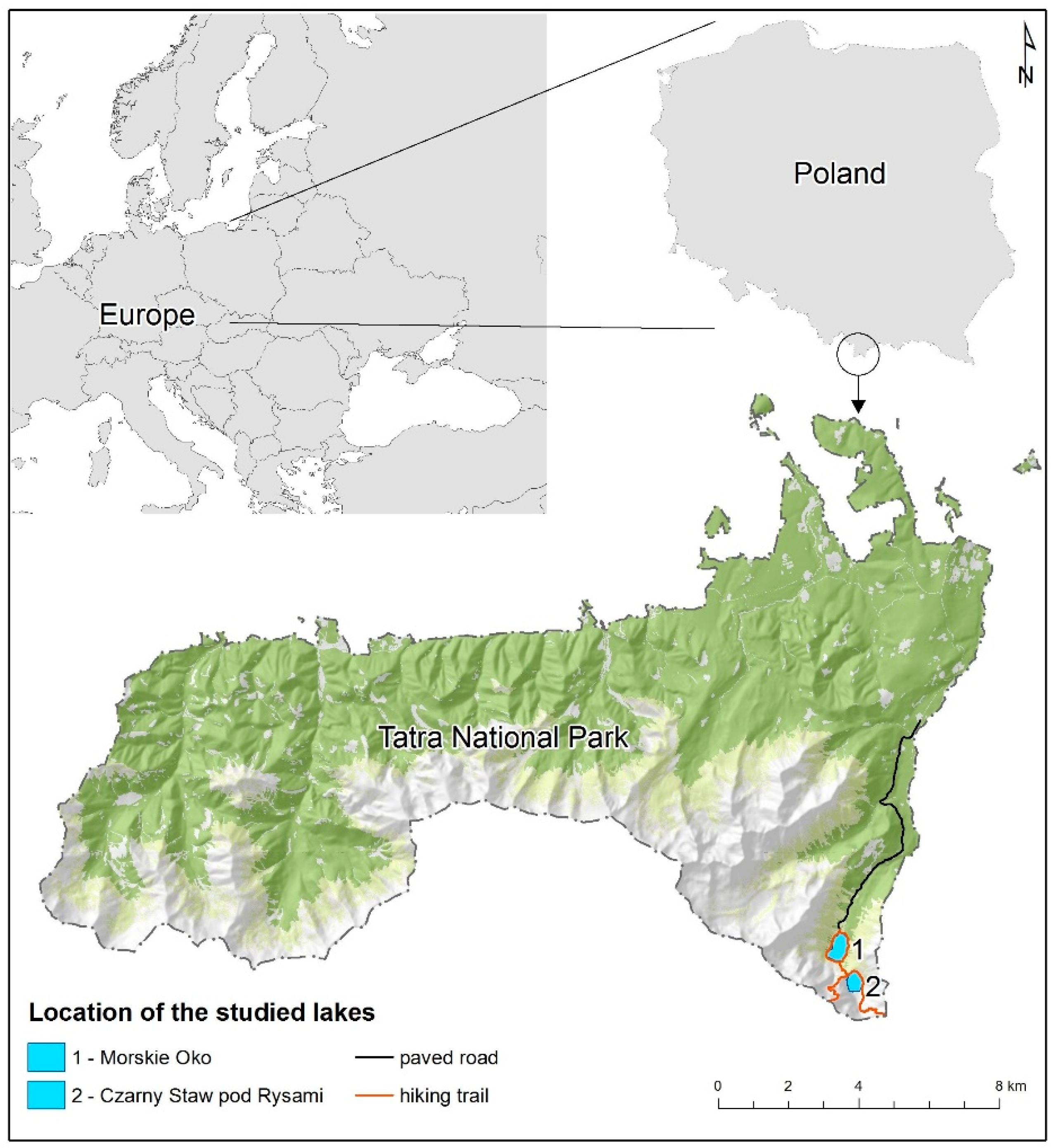
Figure 1.
Location of the studied lakes.

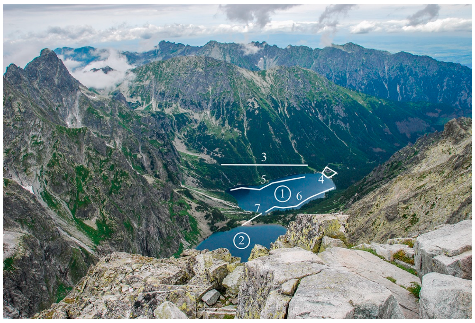
Figure 2.
The studied lakes—view from the Rysy Mountain (2499 m a.s.l.). 1—Lake Morskie Oko; 2—Lake Czarny Staw pod Rysami; 3—trail to Szpiglasowa Przełęcz; 4—lodge in Morskie Oko; 5—trail on the western side of Lake Morskie Oko; 6—trail on the eastern side of Lake Morskie Oko; 7—trail from Lake Morskie Oko to Lake Czarny Staw pod Rysami.

Figure 3.
Weights for lake accessibility and access points to Lake Morskie Oko.

Figure 4.
Weights for lake accessibility and access points to Lake Czarny Staw pod Rysami.

Figure 5.
Accessibility classes (KD).

Figure 6.
Plant cover classes (KP).

Figure 7.
Proposed modifications of the hiking trail.


Table 1.
Number of visitors entering the trail to Morskie Oko based on ticket sales data [33].
Table 1.
Number of visitors entering the trail to Morskie Oko based on ticket sales data [33].
| Entrance in Palenica Białczańska | 2013 | 2014 | 2015 | 2016 | 2017 |
|---|---|---|---|---|---|
| Number of entrances (persons/day) | 5609 | 6140 | 6675 | 7183 | 7445 |
| Percentage of all entrances to the TNP (%) | 30.9 | 36.4 | 34.3 | 34.3 | 35.6 |
Table 2.
Weights for lake accessibility in the examined segments (100 m) of the trail.
| Parameter | Weight | ||
|---|---|---|---|
| 1 | 2 | 3 | |
| X1—Distance from the lake shore (m) | above 6 | (3–6) | up to 3 |
| X2—Average trail height above the lake surface (m) | above 1 | (0.5–1) | below 0.5 |
| X3—Presence of trees and shrubs obstructing access to the lake (%) | above 50 | (25–50) | below 25 |
| X4—Presence of boulders and steep rock surfaces obstructing access to the lake (%) | above 50 | (25–50) | below 25 |
Table 3.
Weights for accessibility to the analyzed lakes, accessibility classes and plant cover classes for the evaluated trail segments.
Table 3.
Weights for accessibility to the analyzed lakes, accessibility classes and plant cover classes for the evaluated trail segments.
| Trail Segment | Parameters and Weights for Trail Segments | Sum of Weights—Accessibility Class—KD | Number of Access Points | Plant Cover (m2)—Cover Class—KP | Correspondence Between KD and KP | |||
|---|---|---|---|---|---|---|---|---|
| Morskie Oko | ||||||||
| X1 | X2 | X3 | X4 | |||||
| 1 | 3 | 3 | 3 | 3 | 12—(I) | 1 | 3630—(I) | + |
| 2 | 2 | 3 | 2 | 2 | 9—(II) | 1 | 431—(II) | + |
| 3 | 1 | 1 | 1 | 2 | 5—(III) | 0 | 72—(III) | + |
| 4 | 1 | 1 | 1 | 1 | 4—(III) | 0 | 396—(II) | +/− |
| 5 | 3 | 2 | 2 | 3 | 10—(I) | 2 | 396—(II) | +/− |
| 6 | 3 | 2 | 3 | 3 | 11—(I) | 2 | 390—(II) | +/− |
| 7 | 1 | 2 | 1 | 2 | 6—(III) | 0 | 323—(II) | +/− |
| 8 | 1 | 1 | 1 | 1 | 4—(III) | 0 | 0—(III) | + |
| 9 | 2 | 1 | 2 | 1 | 6—(III) | 0 | 0—(III) | + |
| 10 | 2 | 1 | 2 | 1 | 6—(III) | 0 | 0—(III) | + |
| 11 | 2 | 1 | 2 | 2 | 7—(II) | 0 | 0—(III) | +/− |
| 12 | 1 | 2 | 1 | 2 | 6—(III) | 1 | 464—(II) | +/− |
| 13 | 2 | 3 | 3 | 3 | 11—(I) | 2 | 646—(II) | +/− |
| 14 | 1 | 1 | 1 | 2 | 5—(III) | 3 | 855—(II) | +/− |
| 15 | 1 | 1 | 1 | 2 | 5—(III) | 1 | 619—(II) | +/− |
| 16 | 1 | 1 | 1 | 2 | 5—(III) | 0 | 257—III) | + |
| 17 | 2 | 2 | 1 | 3 | 8—(II) | 0 | 108—(III) | +/− |
| 18 | 1 | 1 | 1 | 1 | 4—(III) | 1 | 397—(II) | +/− |
| 19 | 3 | 3 | 2 | 3 | 11—(I) | 1 | 543—(II) | +/− |
| 20 | 2 | 2 | 1 | 2 | 7—(II) | 1 | 499—(II) | + |
| 21 | 3 | 1 | 2 | 1 | 7—(II) | 0 | 230—(III) | +/− |
| 22 | 2 | 2 | 1 | 1 | 6—(III) | 0 | 469—(II) | +/− |
| 23 | 1 | 2 | 1 | 2 | 6—(III) | 0 | 4620—(I) | − |
| 24 | 1 | 1 | 1 | 2 | 5—(III) | 0 | 4730—(I) | − |
| 25 | 3 | 3 | 2 | 3 | 11—(I) | 1 | 5213—(I) | + |
| Czarny Staw pod Rysami | ||||||||
| 26 | 1 | 1 | 1 | 1 | 4—(III) | 0 | 0—(I) | + |
| 27 | 1 | 1 | 1 | 2 | 5—(III) | 0 | 0—(I) | + |
| 28 | 1 | 1 | 3 | 2 | 7—(II) | 1 | 0—(I) | +/− |
| 29 | 2 | 1 | 1 | 1 | 5—(III) | 0 | 0—(I) | + |
| 30 | 2 | 1 | 1 | 1 | 5—(III) | 1 | 0—(I) | + |
| 31 | 1 | 1 | 2 | 1 | 5—(III) | 0 | 0—(I) | + |
| 32 | 1 | 1 | 2 | 1 | 5—(III) | 2 | 0—(I) | + |
| 33 | 2 | 1 | 3 | 1 | 7—(II) | 0 | 0—(I) | +/− |
| 34 | 1 | 1 | 1 | 1 | 4—(III) | 1 | 0—(I) | + |
| 35 | 1 | 1 | 1 | 1 | 4—(III) | 0 | 0—(I) | + |
| 36 | 1 | 1 | 1 | 1 | 4—(III) | 0 | 0—(I) | + |
| 37 | 1 | 1 | 1 | 1 | 4—(III) | 0 | 0—(I) | + |
Table 4.
The degree of correspondence between accessibility class KD and plant cover class KP in the evaluated trail segments.
Table 4.
The degree of correspondence between accessibility class KD and plant cover class KP in the evaluated trail segments.
| Full Correspondence | Absence of Correspondence in 1 Class | Absence of Correspondence in 2 Classes | |
|---|---|---|---|
| Morskie Oko | 9 | 14 | 2 |
| Czarny Staw pod Rysami | 10 | 2 | 0 |
| Total | 19 | 16 | 2 |
© 2019 by the authors. Licensee MDPI, Basel, Switzerland. This article is an open access article distributed under the terms and conditions of the Creative Commons Attribution (CC BY) license (http://creativecommons.org/licenses/by/4.0/).
Share and Cite
MDPI and ACS Style
Dynowski, P.; Senetra, A.; Źróbek-Sokolnik, A.; Kozłowski, J. The Impact of Recreational Activities on Aquatic Vegetation in Alpine Lakes. Water 2019, 11, 173. https://doi.org/10.3390/w11010173
AMA Style
Dynowski P, Senetra A, Źróbek-Sokolnik A, Kozłowski J. The Impact of Recreational Activities on Aquatic Vegetation in Alpine Lakes. Water. 2019; 11(1):173. https://doi.org/10.3390/w11010173
Chicago/Turabian StyleDynowski, Piotr, Adam Senetra, Anna Źróbek-Sokolnik, and Jacek Kozłowski. 2019. "The Impact of Recreational Activities on Aquatic Vegetation in Alpine Lakes" Water 11, no. 1: 173. https://doi.org/10.3390/w11010173
Note that from the first issue of 2016, this journal uses article numbers instead of page numbers. See further details here.