1. Introduction
Beaches are of outmost importance for coastal tourism economy in several countries [
1], for example, USA coastal states receive
circa 85% of tourist related revenues [
2]. In 2011 international and national visitors spent US
$5.7 billion at Miami [
3], where the beach is fully maintained via nourishment works according to a strategy that is extremely cost effective [
4]. On the Pacific coast, Venice Beach (California) has 16 million annually tourist visits, more than the combined visits (
circa 12 million) to Yellowstone, Yosemite and Grand Canyon National parks. Tourism revenues are even more important in small countries and islands, for example, in Hawaii, beaches supply one third of all jobs in the State [
5] and, in the Mediterranean, the small island (8336 km²) of Crete (Greece), is visited by 2.8 million tourists annually [
6]; Balearic Islands (4992 km
2), Spain, recorded almost 20 million visitors in 2017 with an associated amount of revenues of 16 M€—an increase of 12% respect to 2016 [
7]. Sea side tourism is a relevant part of the Italian economy too, with 118.6 million visits in 2016, 29.5% of the whole national tourism [
8]. Bathing establishments produce an Economic Value Added (EVA) of 800 M€ per year, more than 3% of the Italian EVA and give work to 300,000 persons [
9]. Coastal tourism is strongly affected by beach erosion [
4,
10,
11]. For example, at the Hoi, an World Heritage site in Vietnam, the total annual revenue losses for beach erosion in 2020 are estimated in 29.6 M US dollars [
12].
A The Bahamas, the economic losses in properties and accommodation offer for the next 20 years could be up to US
$44 billion [
13]. In Jamaica coastal erosion affects beaches, properties and coral reef: present annual economic losses (valued at 19 M US
$) could record an additional US
$1.3 million per year increase if the reef continues to degrade—because of the loss of tourism related activities [
14].
Erosion trend acquires a great relevance in Italy too, where 41.9% of the beaches are eroding, that is, 1657 km out of 3951 km [
8]. This process started in Northern Italy and progressively expanded to the south, following the economic development of the country [
15] and was immediately opposed with shore protection structures. Only recently important beach nourishment projects have been carried out but hard shore protection is still the most frequent option, thanks to the familiarity that administrators, technicians and stakeholders have with them, notwithstanding the negative impact they can have on the coastal system.
Shore protection structures are known to have been built at least since the 1st century B.C. in Germany [
16,
17] and The Netherlands [
18]; the 6th century A.D. in Venice [
19], the 8th century in China [
20] and the beginning of the 16th century in Belgium [
21]. Most of these ancient structures aimed at protecting short coastal segments, frequently where villages or military structures were located [
22] but the need to prevent storm surge flooding in subsiding coastal lowlands along the North Sea brought construction of long dykes, for example, in Germany as early as the 11th century [
23].
Nineteenth century coastal development (human settlements, industrial areas, communications) and the emergence of widespread coastal erosion (due to sediment input reduction, coastal structure construction and sea level rise) caused an increase of shore protection structures. These extended further where coastal tourism started to be a social fashion as well as an economic business. Buildings, generally second houses and hotels, stretched along the coast, at places on the foredunes or even on the beaches themselves, reducing enormously coastal resilience [
24].
However, in Spain [
25] and in many Mediterranean countries, coastal protection structures really mushroomed only post WWII due to the low level of human occupation, the moderate tourist demand for beaches and the low intensity of erosion problems [
26]. In Italy and France, the coast was mostly depopulated [
27,
28] and only a few tourist destinations existed in well-established localities. Protection of isolated buildings, coastal roads and railways and promenades was mostly performed with revetments but this system was gradually abandoned after the 1940s.
Examples of this trend have been reported for many countries, from Italy [
25] to Spain [
27], which is now the European premier beach holiday tourist destination [
29,
30]. In the Tropics, Mexico, with international tourism [
31,
32] and Colombia, with a national one [
33], are following the Italian bad example. Similar evolution has been experienced by countries not in any seaside destination list, such as, Québec, Canada [
34] and Washington, USA [
35].
Most of the first Italian projects utilized revetments but beaches disappeared in sedimentary deficient areas. The introduction of detached breakwaters produced limited results and the structures proved to be unsuitable for bathing activities; groin fields followed and were expanded with the backing of beach concessionaires.
However, coastal tourism has come into conflict with traditional coastal defence works, inducing their transformation into submerged structures, like happened in the study area. Similar projects have been carried out in other places in Italy, for example, at Follonica [
36] and Igea Marina [
37], where detached breakwaters have been widened and lowered below sea level. Examples can also be found in other countries: in Spain, at Marbella and Benalmádena, groins were greatly reduced in numbers [
38] and, at Estepona (Spain), they were removed and submerged shore-parallel structures substituted; a similar project was carried out in Greece, at Katerini beach [
39]. Demolition, or abandonment of 19 shore-parallel seawalls present at Sandy Hook Spit, New Jersey (USA), was proposed along 10 km of coastline including both the ocean and bay shores to allow natural shoreline processes to prevail as part of a strategy of adaptation to sea level rise associated with climate change [
40]. Beach nourishment often accompanied these works.
This evolution is understandable only if the economic value of these beaches is considered, not only for beach activities but also the spin-off on several components of the tertiary economy. Research carried out on the northern coastal segment on beach value perception by the managers of different economic activities (bathhouse, hotels, restaurants, fashion shops, news sellers, food stores, etc.) has proved this statement [
41]. Most interviewees answered that the loss of beach could induce closure of their activity. Interviews were done within 2 km from the shoreline and the perception of beach impact on economic activities slowly reduced inland but remained relevant.
In many cases it is not possible to trace coastal erosion development together with shore protection proliferation, due to the lack of both shoreline data and structures construction and modification through time. For the present case study, both shoreline position and structure construction time are available from 1878, when the beach was stable or accreting; in addition, along the investigated coast, urban settlements, tourist places, commercial/recreational harbours and natural parks are present, allowing identification as to how shore protection structures are designed to counteract beach erosion, which recently has been coming under increasing pressure from the tourism industry.
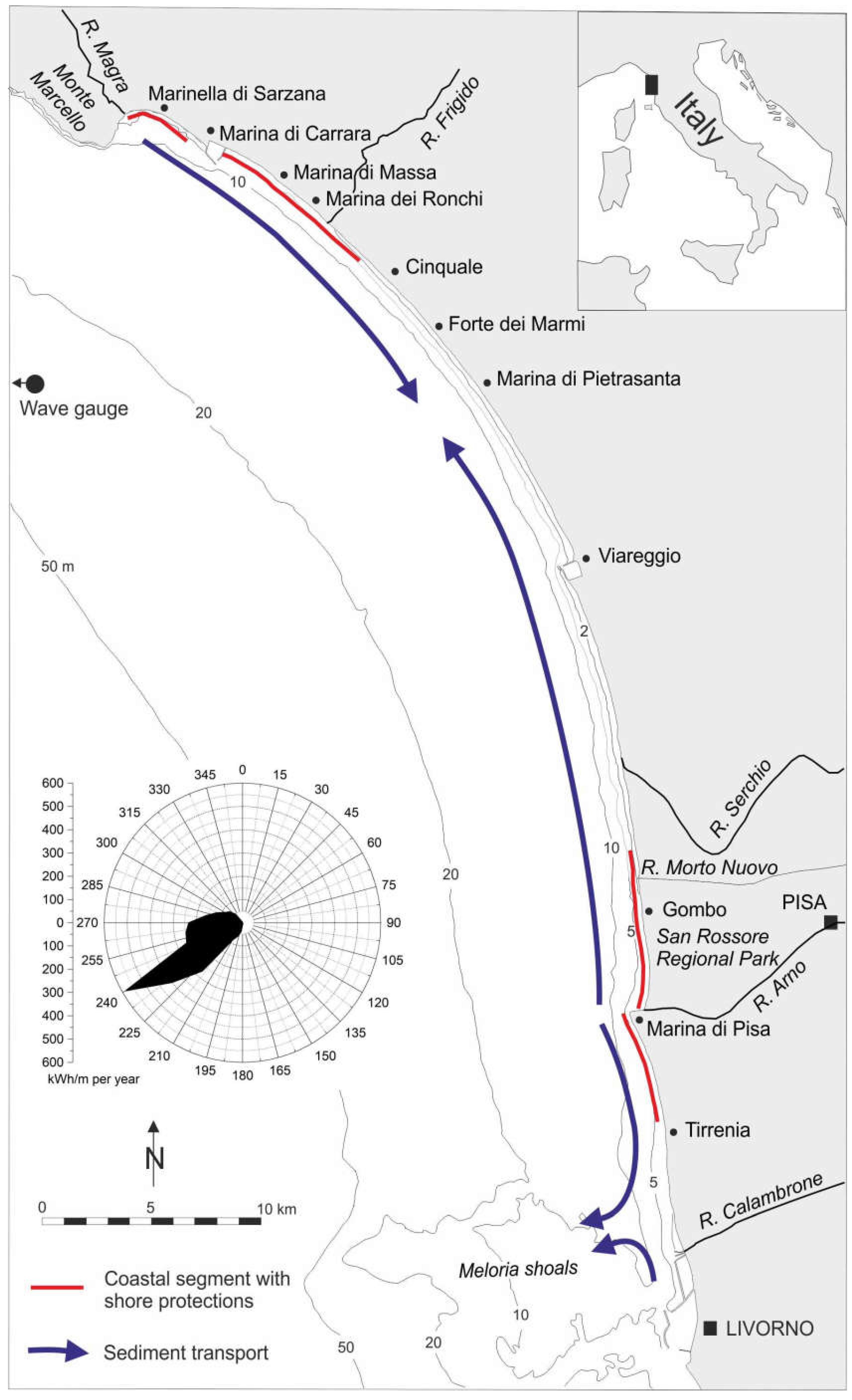
2. Study Area
A continuous 63.5 km-long sand barrier connects Monte Marcello promontory to the Livorno rocky salient (
Figure 1), where the largest harbour of Tuscany was constructed in the 16th century. Three main rivers empty on this coast, R. Magra, close to Monte Marcello, R. Serchio, 39 km to the south and R. Arno, 11 km from the southern limit of the physiographic unit. The latter is the main feeder river of this coast, with approximately 1,524,000 t/year of total load [
42], R. Magra contributes with 632,000 t/year to the coastal sediment budget [
43], whereas R. Serchio, whose watershed is in large parts on limestone gives a limited input (approx. 23,000 t/year, [
43]). River Magra, coming down from high mountains close to the coast, brings mixed sand and gravel sediments, whereas R. Arno, crossing the Florence and Pisa plains, deposits all its coarse sediments before reaching the sea. Present input is far lower than that of the previous centuries: for example, R. Arno sediment yield is only 37% of that estimated for the 1500–1800 AD period [
44].
Other small water courses (e.g., Cinquale, Versilia and Calambrone), although their bedload has never been assessed, are considered by the authors to be insignificant to the sediment input.
Wave climate is characterized by a limited wave angular dispersion, with storms coming exclusively from the SW (
Figure 1). Longshore transport diverges at the River Arno delta apex and sediments from this river feed the coast as far as Livorno and up to Marina di Pietrasanta, where a convergence with sediments coming from the R. Magra was identified via morphological, sedimentological, petrographic and numerical models [
44,
45]. The littoral unit is divided into four main littoral cells [
46] (
Figure 1), from north to south these are:
- (i)
Monte Marcello—Marina di Pietrasanta;
- (ii)
Marina di Pietrasanta—R. Arno mouth (these two are limited by a convergence zone);
- (iii)
R. Arno mouth—R. Calambrone mouth (limited by the previous by a divergence zone);
- (iv)
the small cell in the R. Calambrone—Livorno area, limited by a convergence zone and produced by wave reflection on the oblique breakwaters of the harbour [
47,
48].
Two harbours intercept longshore transport: the first is Marina di Carrara, whose breakwaters have been extended to a 10 m water depth allowing only finer sediments to overpass the port structure; the second is Viareggio harbour, whose entrance originally was at −5.0 m and now—after the updrift beach reached the breakwater tip—allows natural sediments bypass.
Coastal tourism started very early on this coast with the first bathing facilities built at Viareggio in 1827, where Liberty bathhouses, kiosks and hotels still increase the tourist attractiveness of the site. Bathers from Pisa were crowding at Gombo, where a bathhouse has been active since 1830s and ended when it was moved in 1869 to the southern side of the R. Arno delta because the land owner, King Vittorio Emanuele II, did not like so many visitors. Three years later (1872), on the same side of R. Arno, Marina di Pisa was founded after a masterplan drawn by the Pisa Municipality to create a tourist “new town”: a careless decision, since the delta of the River Arno, where the settlement was located, was just showing the first signs of an erosion trend that, on the unprotected northern delta lobe, resulted in 1.3 km of coastal retreat in the following 120 years. The area became Presidential property in 1956 but was then given to the Tuscany Region in 1999 and now is a regional park.
In the northern sector, industrial activity—at first connected with Carrara marble quarries—was gradually flanked and later overpassed by tourism activity; marble loading piers, replaced by the Marina di Carrara harbour, now are tourist attractions. Viareggio harbour, originally a small dock along a drainage channel, which grew with several expansions protruding into the sea to reach the present configuration, now hosts few fishing boats but several recreational boats and is bordered by dockyards building mega yachts sailing on the world seas.
It is difficult to evaluate beach tourism economy since available data on tourist revenues for the investigated zone are aggregated within administrative areas, that is, provinces. Hence, they include revenues linked to both tourism in towns (in this case Pisa, Lucca and Livorno) and beach tourism related activities. However, a proof of importance of the latter is provided by the number of bathing establishments located along this coast: excluding the Regional Park, where this activity is not allowed, 645 concessions are given (15 for each km of coast); here concessionaires not only rent cabanas and beach umbrellas but also manage bars and restaurant. The average cost for a cabana plus one beach umbrella and two sun chairs is about 40 €/day in this area and umbrella density is approximately 1/10 m2 of beach.
3. Materials and Methods
Shoreline evolution was studied starting from a dataset developed at the Earth Science Department of the University of Florence and based on the ortho-rectification of 1938, 1954, 1967, 1978 and 1985 aerial photographs, integrated in 2005 with direct DGPS surveys. The late 1800s shoreline position was taken from the first edition of the 1:25,000 topographic maps of the Istituto Geografico Militare (IGM) [
49] produced between 1878 and 1881, from now on referred as the 1878 shoreline. The 2017 shoreline was extracted from high resolution satellite images (Pleiades) by the “Consorzio LaMMA” within a commitment conferred by the Tuscany Region government. Shoreline position accuracy was estimated to be 30 m for the 1878 shoreline, 10 m for the 1938 to 1985 shorelines and 1 m for the 2005 and 2017 ones [
50,
51]. Beach erosion and accretion values are considered significant if they exceed the accuracy of the figures given. For the present study, the 63.5 km long coast was divided into 246 sectors; each one being approximately 250 m long and representative of a uniform (natural or artificial) coastal sector.
For each sector and time interval, beach surface variation (m
2) was measured [
52] via Geographic Information System (QGIS) and mean shoreline displacement value (m) was computed. Coastal structures type, position and length were acquired from the University of Florence dataset and from geo-referenced aerial photographs; in addition, several later IGM map editions were used. To each structure (or modification) the construction time was considered as the year of its first appearance in the maps/air photos, unless more specific information were available from written reports; this gives a “stepped shape” to the lines tracing the growth of the structure length. Old photographs and postcards were helpful in this research.
Coastal armouring is the result of the construction of different structures, some addressed to oppose beach erosion (seawalls, revetments, groins, detached breakwaters, etc.), others to stabilize the entrance of rivers and channels or as part of harbours. The latter structures often cause downdrift beach erosion that requires emplacement of protection structures. Although this paper deals with the temporal evolution of coastal structures (i.e., time is the first variable), their description will follow a geographic sequence (from north to south). However, for reasons of clarity, the analysis will start from three erosion hotspots: the two main river mouths and the harbour of Marina di Carrara.
4. Coastal Erosion
Since sea level stabilization (approx. 6000 year ago) this coast was accreting due to the huge amount of sediments delivered by the two main rivers (Arno and Magra). Only two significant erosion phases have been recorded on the River Arno delta, the first at the Fall of the Roman Empire, the second consequent to the 14th cent. Black Death; in both the cases a tremendous demographic crisis occurred accompanied by the abandonment of many cultivated areas where forest grew back [
48].
The present coastal erosion phase, just like the previous, started at river mouths and gradually extended to lateral beaches [
53]. The main causes were river sediment input reduction due to reforestation, dam construction and river bed quarrying. Further, harbour construction and the first shore protection structures increased the intensity of erosion processes. Following the longshore transport direction, erosion expanded north and south of the R. Arno mouth and south of the R. Magra one (the coast to the north is rocky).
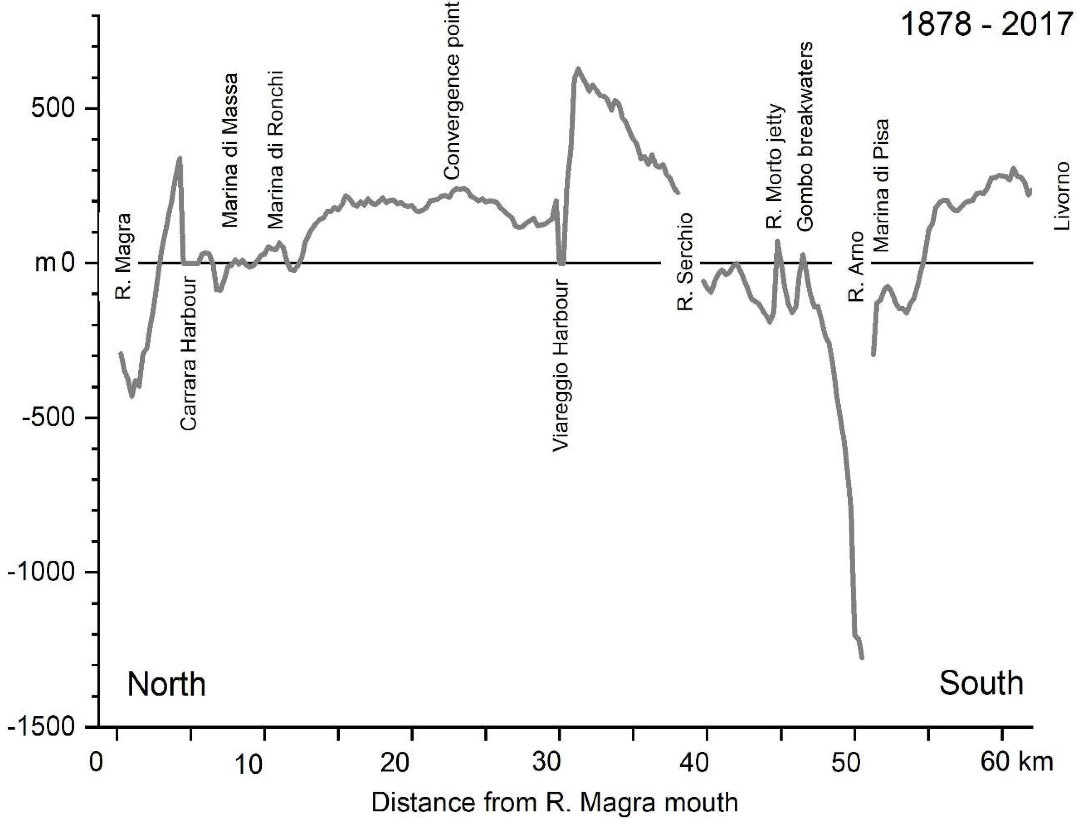
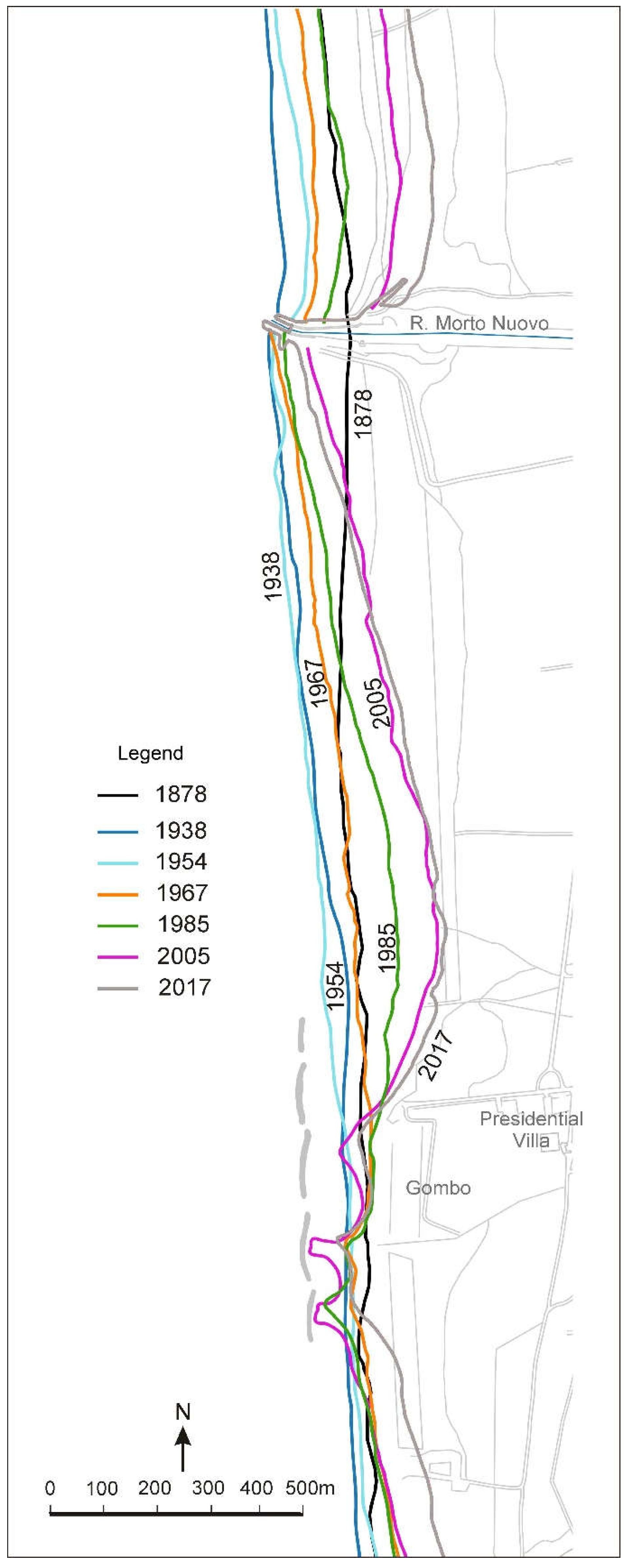
On the southern lobe of the R. Arno, the “new town” of Marina di Pisa was under construction when beach erosion started. When approximately 150 m of beach was lost, shore protection projects were initiated; on the delta uninhabited northern side nature was left alone and 1300 m of land disappeared (
Figure 2). Only a small coastal sector located 4 km to the north, where the Presidential Villa is located, was in the early 1960s protected with 5 detached breakwaters that increased downdrift erosion reflected by an evident log-spiral plan form [
54].
Approximately 1.5 km to the north occurs the Fiume Morto Nuovo (New Dead River) outlet, an artificial mouth of the Fiume Morto draining the northern Pisa plain, which was diverted to the south in 1926–1930 to shorten its course and favour water discharge. In 1933, jetties were built, which were further extended with several projects. This had a strong feeding effect and now the downdrift beach is some 260 m narrower than the updrift one (
Figure 2).
Proceeding to the north, the continuous seaward expansion of Viareggio harbour, carried out to guaranty deep water at its entrance, induced downcoast erosion until a by-pass system was constructed in 1954 [
55]. This proved to be expensive and became useless when sediments started to naturally bypass the structure. However, the bar overpassing the harbour entrance is frequently dredged and sediments deposited to the north.
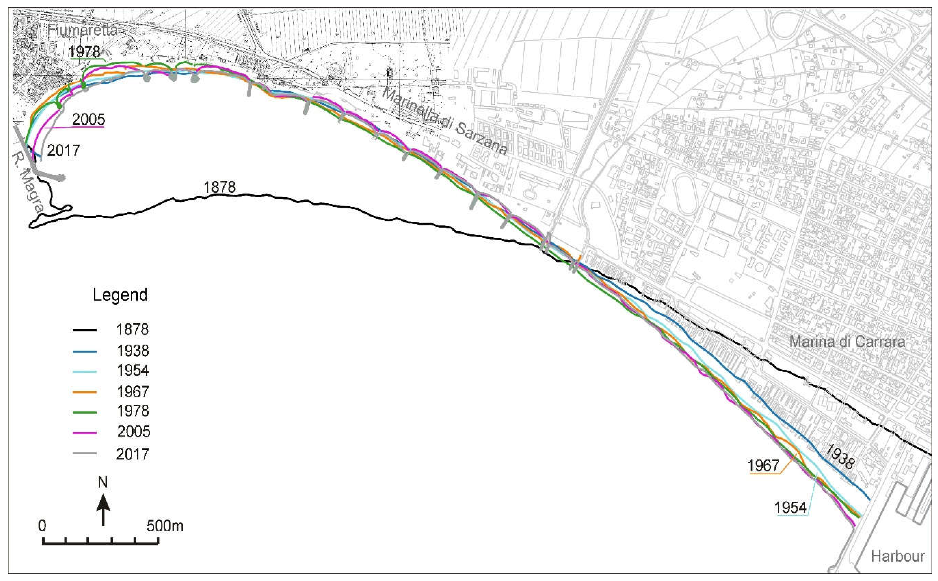
On the northern side of the coast (
Figure 3), the R. Magra never built a real delta but the Istituto Idrografico della Marina Italiana (IMI) 1881 nautical chart shows a salient in correspondence with the 5 and 10 m isobaths [
56]. In 1938 approximately 3 km of coast to the south side of the river mouth were eroded, with a recession of more than 500 m; on the IIMI 1954 nautical chart the salient is no longer present [
56].
When erosion nearly reached Marina di Carrara (
Figure 3), harbour construction began. The project was redacted in 1920 but work started in 1922 [
57] and the beach of this locality—otherwise destined to be eroded—started to expand so much that today it is approximately 300 m wider than in 1920s (
Figure 2 and
Figure 3). This favoured and accelerated erosion processes on southern coastal sectors (i.e., downdrift of the harbour,
Figure 2), where now 10 km of intensively developed coast is severely eroding and a variety of shore protection structures have been built.
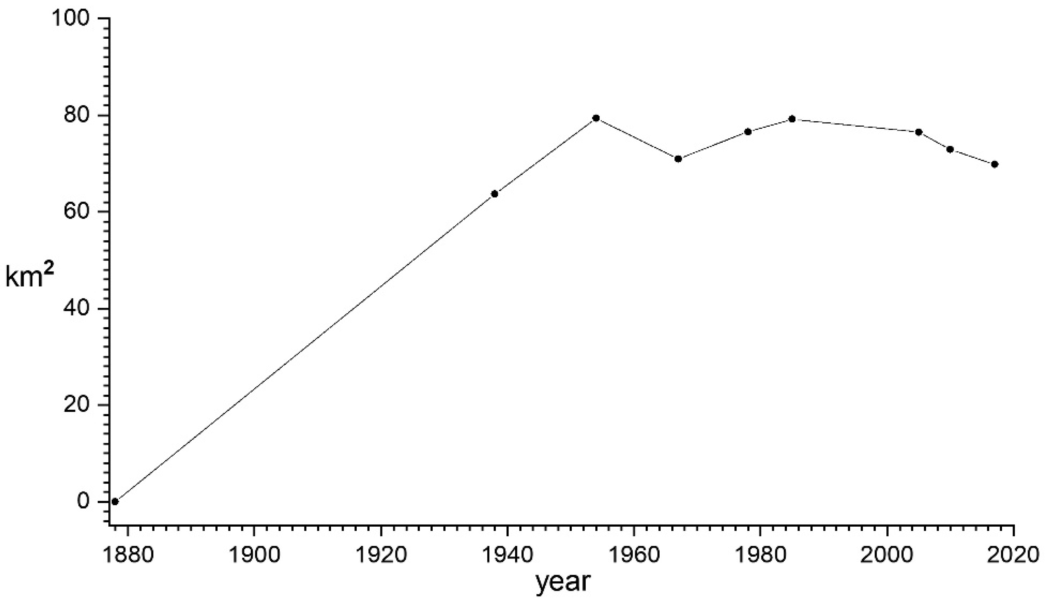
Over the whole coast (Monte Marcello—Livorno), available data shows that the beach surface grew until 1954 with a mean shoreline displacement of approximately 80 m (
Figure 4). The 1967 survey was performed to evaluate damages done by intense storms, which concurrently occurred with the November 1966 flood in Florence and a mean shoreline retreat of 8.3 m was registered. However, in the following years, part of this loss was recuperated and the total beach surface in 1985 was approximately the same as in 1954. Post this, a gradual surface reduction took place and, in 2017, the total beach surface was 9.6 m narrower than in 1954 but remained 69.8 m larger than in 1881 and 6.1 m larger than in 1938. Things are not so beneficial as these figures would let it be imagined: this positive budget is the result of very wide beach progradation and severe diffuse erosion. Whereas beach expansion gives limited gains, especially where sand surface exceeds the needs of tourists [
58], beach erosion prevents, or strongly compromises this economy [
59].
In the last years (2005–2017;
Figure 5) some projects gave positive results: south of the Magra River sediment bypassing from the river terminal course to the beach allowed beach expansion (
Figure 3). This sediment movement was possible because, after several decades of river dredging prohibition, the natural sedimentary dynamics was restored and sediments were able to arrive to the mouth.
At Marina di Ronchi emerged and submerged groins were built and a few nourishment works carried out: this allowed to revert a decennial negative trend. Similar structures stopped coastal erosion north of R. Arno mouth where erosion recorded values of 10 m/yr during the 1997–2000 period. Gravel nourishment at Marina di Pisa returned the beach to this town after one century. The opposite is still the situation updrift of the R. Morto Nuovo jetty and between Marina di Pisa and Tirrenia but the largest erosion is observed at Gombo, where a project based on an artificial tombolo built with a geotextiles failed and up to 80 m of shoreline retreat was registered during the 2005–2017 period (
Figure 5).
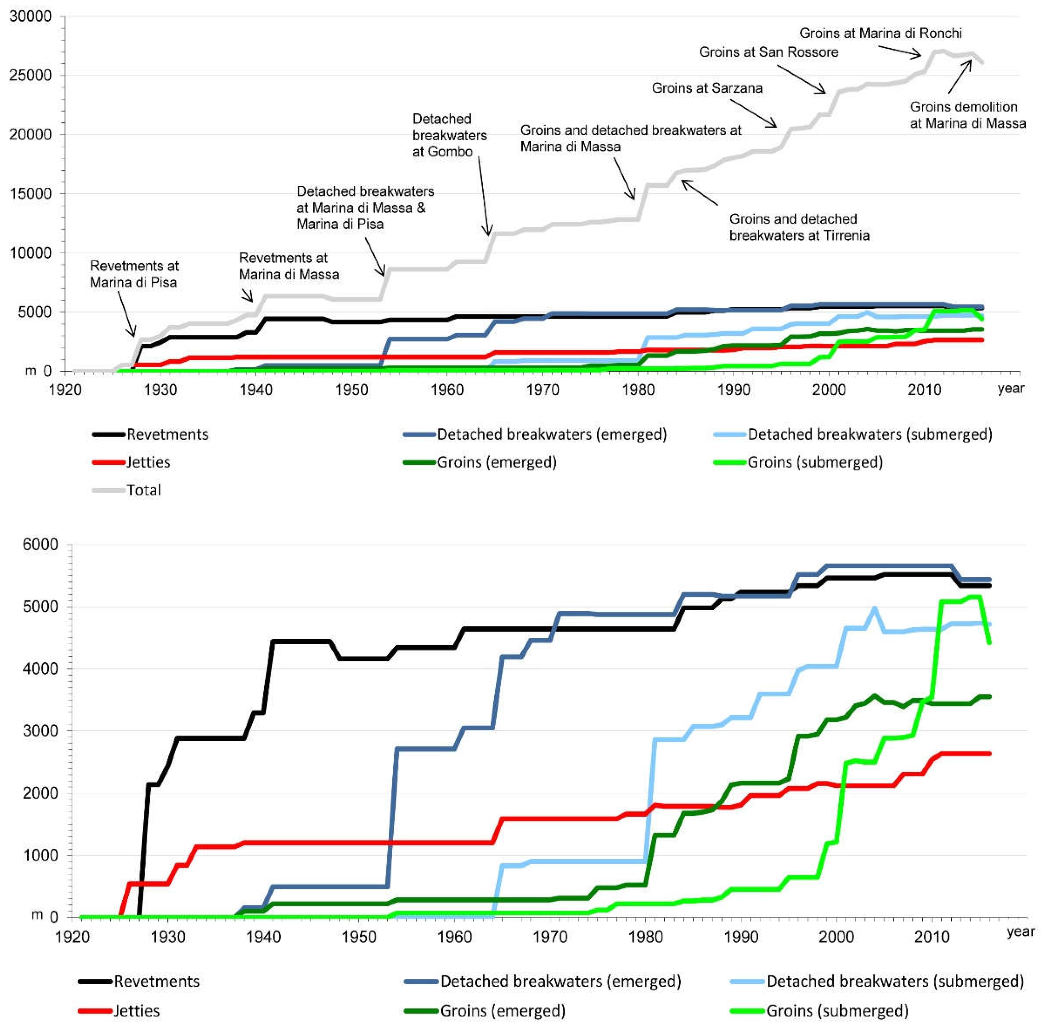
4.1. Coastal Structures Number, Type and Length
In addition to the two harbours whose breakwaters extend for about 3420 m and occupy a coastal length of 1800 m, 160 individual structures (155 still existing) were mapped for a total length of 29,995 m (
Table 1;
Figure 6). There are 16 jetties at river/channel mouths, which extend for 2534 m; some of which were originally groins but the jetties later built on the other side of the channel flanked the river mouth (e.g., Brugiano R.); others act as real groins with a relevant updrift and downdrift effect (e.g., R. Morto Nuovo).
Seawalls and revetments extend for 5405 m, at some places faced by emerged detached breakwaters, for example, at Marina di Pisa. The latter are 34 in number for 5415 m, whereas 15 are submerged and extend for 5098 m.
Traditional groins are 47 in number for a total length of 3652 m and 31 in number (4421 m) are completely or partially submerged, in rocks, geotextiles or precast concrete. There are also three rocky artificial islands; but this figure does not consider other similar structures that after construction have been connected to the land and now are considered as groins (e.g., south of R. Magra mouth). To these structures, four fishing piers for a total length of 1180 m are to be added: at Marina di Massa (215 m), Forte dei Marmi (300 m), Marina di Pietrasanta (380 m) and Lido di Camaiore (285 m). The first two were built in the last quarter of the 19th century for the shipping of marble, the latter two were constructed between 2005 and 2008 for tourist use only. Since they do not interact with coastal dynamics, they will not be considered further.
4.2. Coastal Armouring Development
On the 1878 IGM map (1:25,000 scale) no coastal structures are present along the investigated area, except for two 300 m long jetties at the Canale di Burlamacca, the entrance to the Viareggio dock. They were built in the 16th century to allow safe boat entrance to the channel and continuously extended to cope with the accreting beach (since they were later incorporated into Viareggio harbour, they are not considered in
Figure 6). Beach asymmetry is well evident, with the southern side (updrift)
circa 125 m wider than the northern one (downdrift).
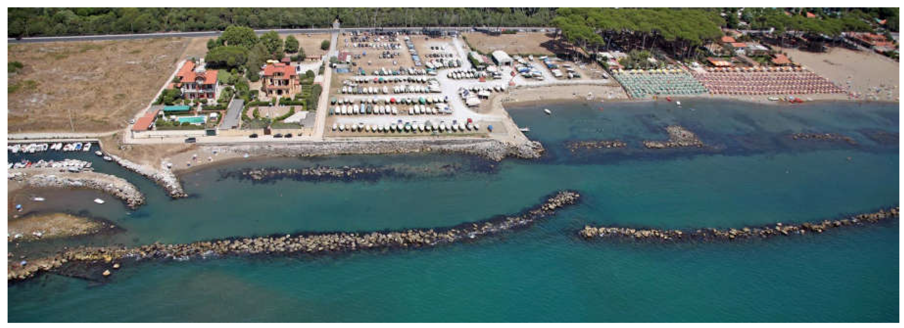
On the 1938 IGM map a detached breakwater is present on the northernmost sector, where the road connecting Sarzana with Marina di Carrara turns to follow the coast (
Figure 7); this structure was built after 1928 and, although deteriorated, still exists. On the same map a
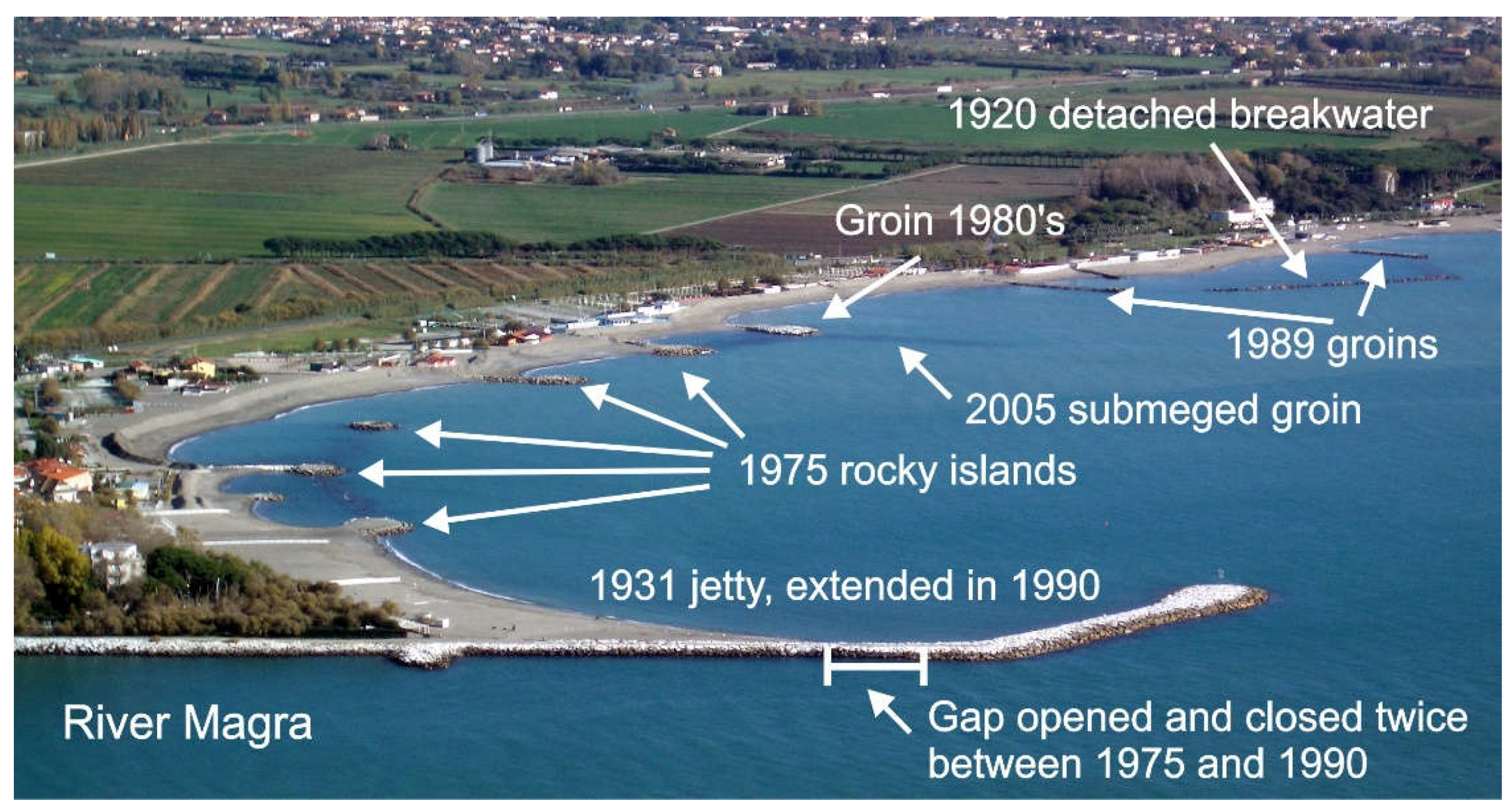
circa 300-m-long jetty is present on the R. Magra outfall’s southern side; it was built in 1931 to prevent river mouth siltation both to favour river discharge during floods and to allow boat access to shipyards located along the river’s terminal stretch.
Reduction in river sediment input and offshore dispersion induced by this jetty, trigged downdrift erosion but as this sector was almost undeveloped, shore protection was limited to the above-mentioned detached breakwater. It was only in the 1970s that the beach at Fiumaretta (at the river mouth) was defended by five rocky round islands and some of these were further joined by submerged breakwaters or connected to the shore with short groins (
Figure 3 and
Figure 8). Further changes to the structures were carried out in the 1980s, adding and reshaping elements and in 2005 an artificial island was extended seaward with a submerged groin. In 1982 a gap was opened in the jetty at the river mouth to allow sediments to feed the beach but due to induced sea water pollution and stakeholders’ complaints, it was closed in 1990.
To the south, at Marinella di Sarzana (
Figure 3), eight groins were built between 1989 and the mid-1990s and three of them were extended with submerged segments in 2005, within a major defence project which was never finished. It is in these years that orthogonal structures exceed revetments in length (
Figure 6).
Even more complex is the evolution of the structures at Marina di Massa, where shore protection projects registered several failures leading to demolition or modification of previous works, whose history is almost impossible to be fully reconstructed. The most detailed account for this area was given by [
59], which analysed all available projects at the local office of Genio Civile per le Opere Maritime (Coastal Engineering Department of the Public Work Ministry).
As previously stated, coastal erosion was approaching Marina di Carrara beach when harbour construction started in 1922 (
Figure 3); the updrift coast inverted its trend but the downdrift sector was severely eroded. Here, 300 m of coast was protected with a revetment and detached breakwater in 1930, both being progressively further expanded to the south to reach respectively 500 and 800 m in 1939 (
Figure 6).
At the beginning of the following decade shore protection expanded more to the south for approximately 2 km, with revetments and detached breakwaters and at the end of the 1950s the coast south of the harbour was defended for more than 3 km (
Figure 9). Not only revetments and detached breakwaters were extended but they also needed several maintenance works and strengthening.
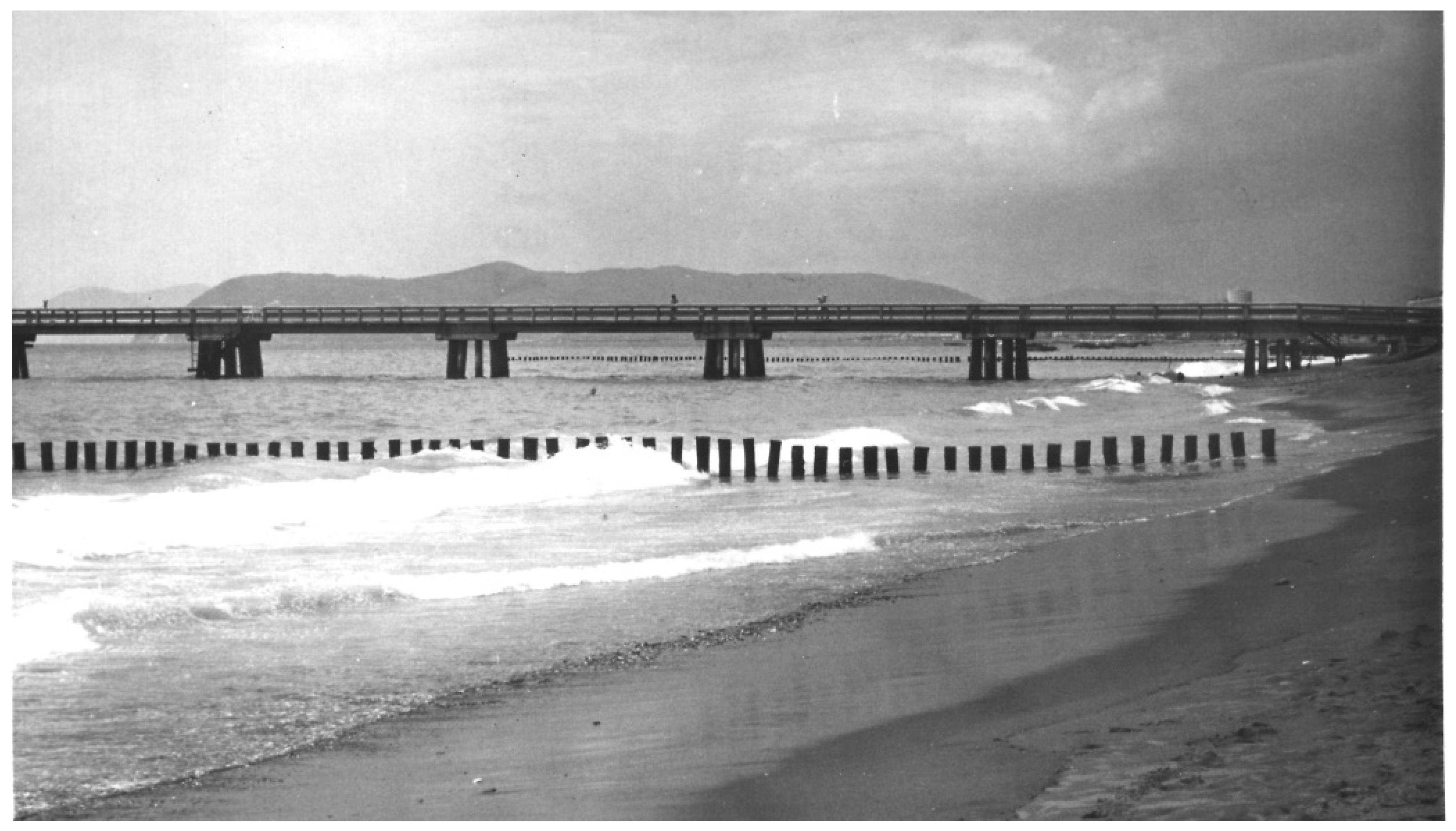
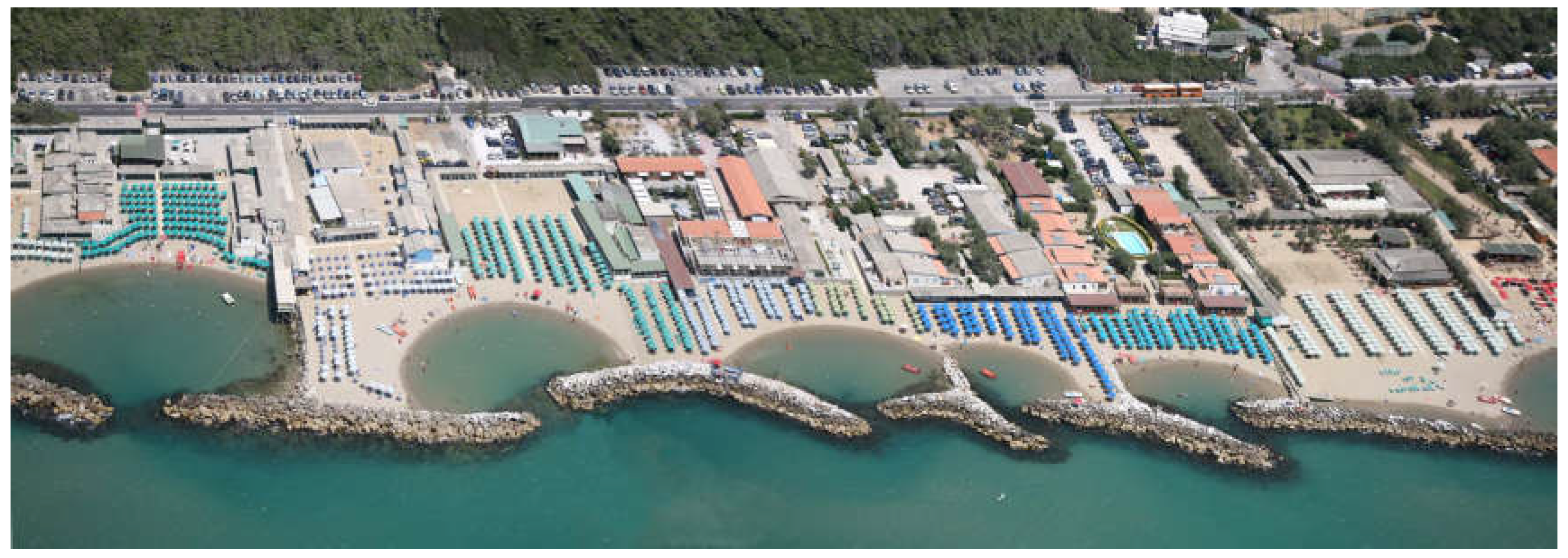
Further south, where the beach was accreting until 1938, in 1954 it was approximately 100 m narrower. Here coastal road and houses were far from the shoreline but the back beach was occupied by bathhouses fronting a beach surface on which to locate sun umbrellas. This surface gradually reduced and structures, at that time built with timber, were continuously set back, until the road prevented any further retreat. Permeable groins with timber poles—but also with iron bars—were built but no information remains except from some old photographs (
Figure 10).
Contrary to what was carried out in the sector immediately south of the harbour where the road was protected with revetments and the beach was lost, here the stakeholders request was to prevent further retreat and maintain the beach. In the late 1970s–early 1980s—an attempt was done by emplacement of four (out of the six designed) artificial round islands [
59] but their ineffectiveness soon suggested to build a landward connection with groins and a submerged breakwater connecting the islands.
Coastal armouring proceeded to the south with nine very closely spaced groins (average Length/Distance = 1) unable to intercept longshore transport (see [
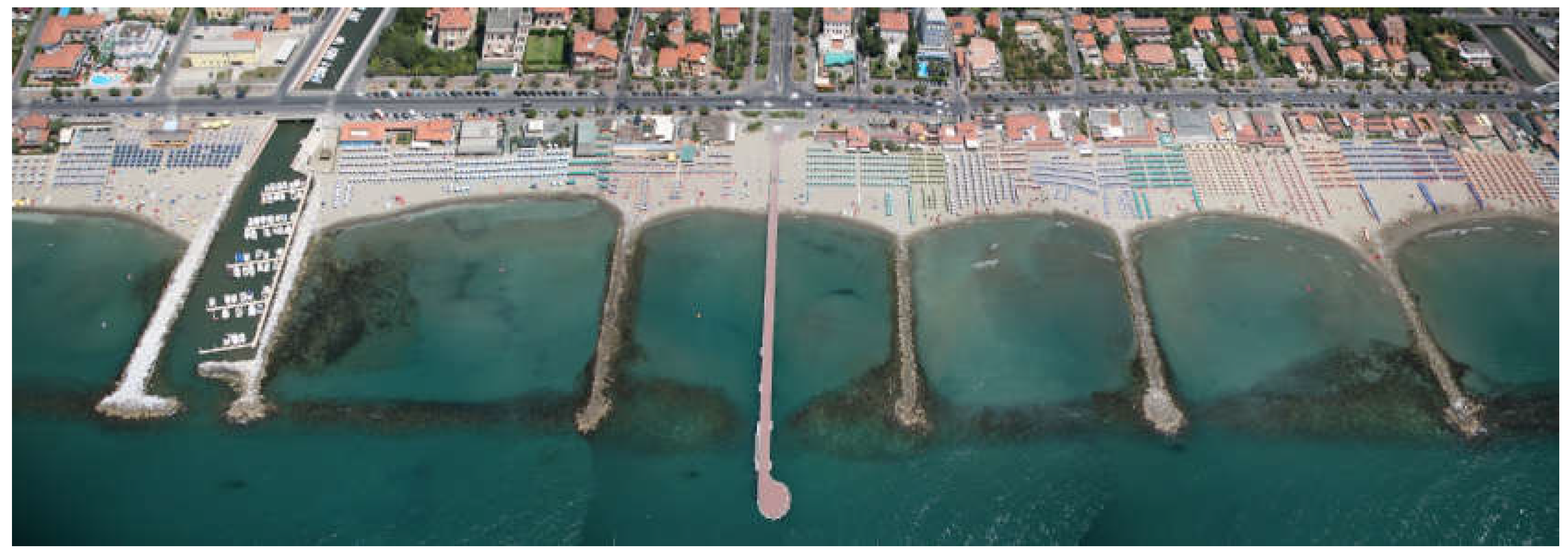
60] for a functional design of groin systems) and the beach continued to be eroded even if a submerged breakwater was constructed to connect their tips. Only rising it to the mean sea level favoured effectiveness of the defences and the beach expanded for approximately 16 m on average [
61]: very fine sand enters in suspension into the protected area during storms producing a not very attractive tourist beach but one which is very appreciated by concessionaires that are able to rent more sun umbrellas (
Figure 11).
Downdrift erosion was soon evident at Marina di Ronchi [
62], where a similar project was required by the concessionaires to stop erosion and, possibly, to enlarge the beach surface. Awareness that a further erosion expansion could occur, lead authorities to test different solutions and submerged groins constructed with experimental sand bags were emplaced [
63]. After positive results, a more complete project started in 2009–2010 with seven submerged groins formed by geo-containers extending to a 4 m water depth. In 2012–2015 the inshore part was replaced by rock groins with a submerged extension, which partly covered the geotextile elements. A jetty with an “L” shaped submerged extension was built on the southern side of the Magliano R. mouth, which limits Ronchi beach to the north. It worthwhile to report that artificial beach nourishments accompanied most of these works, especially the most recent ones.
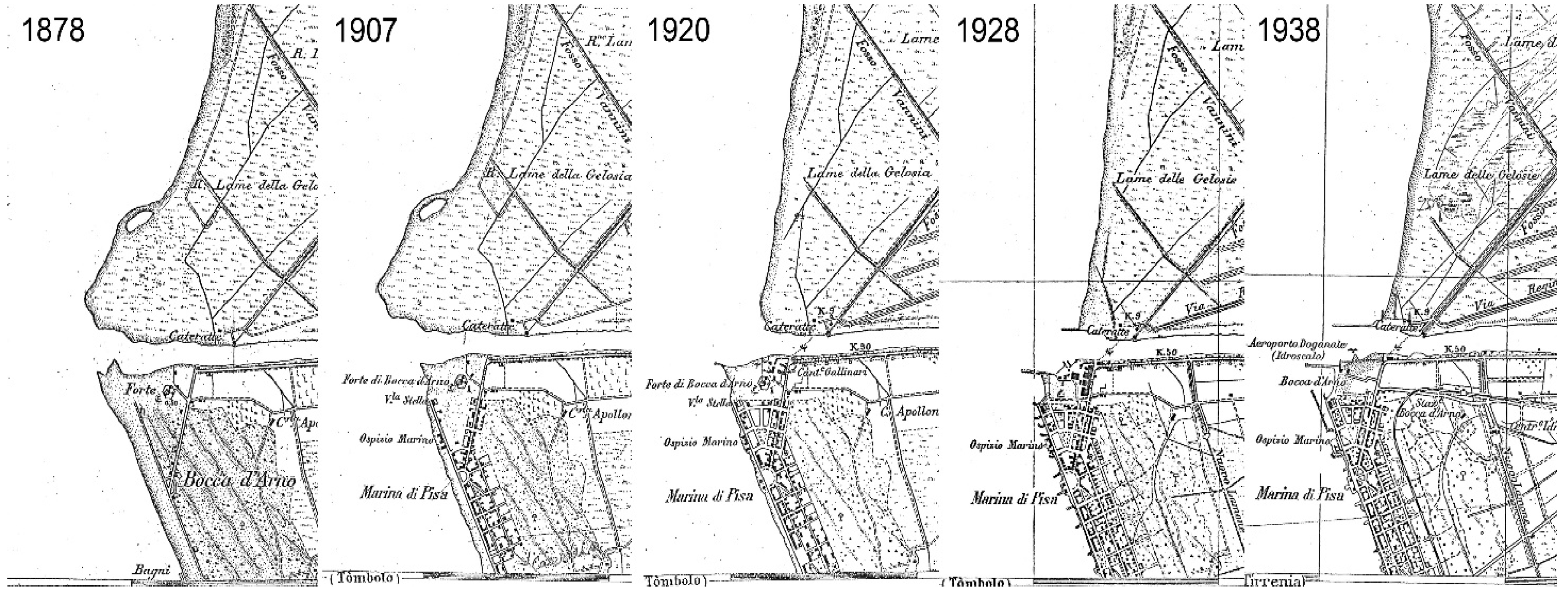
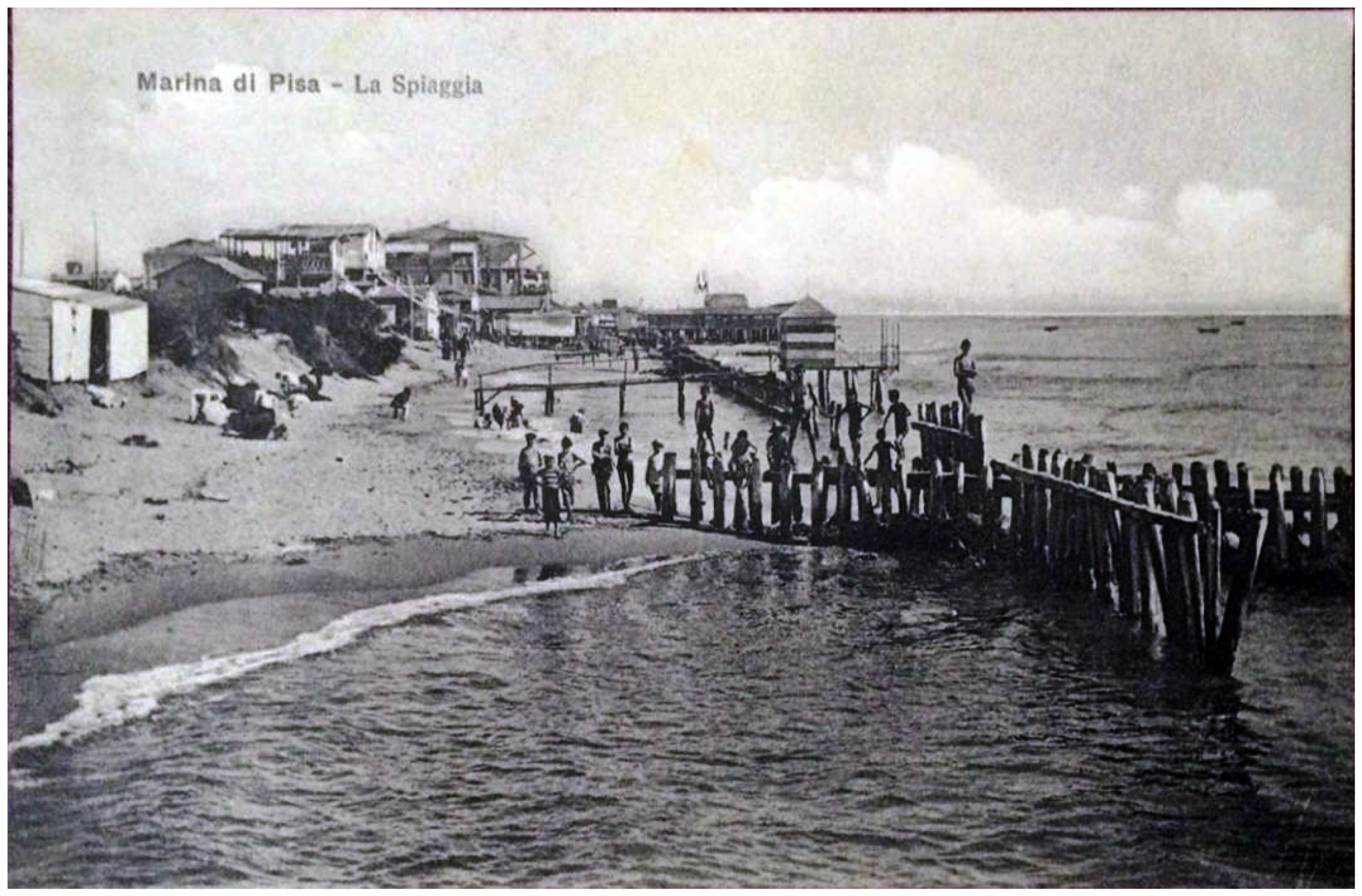
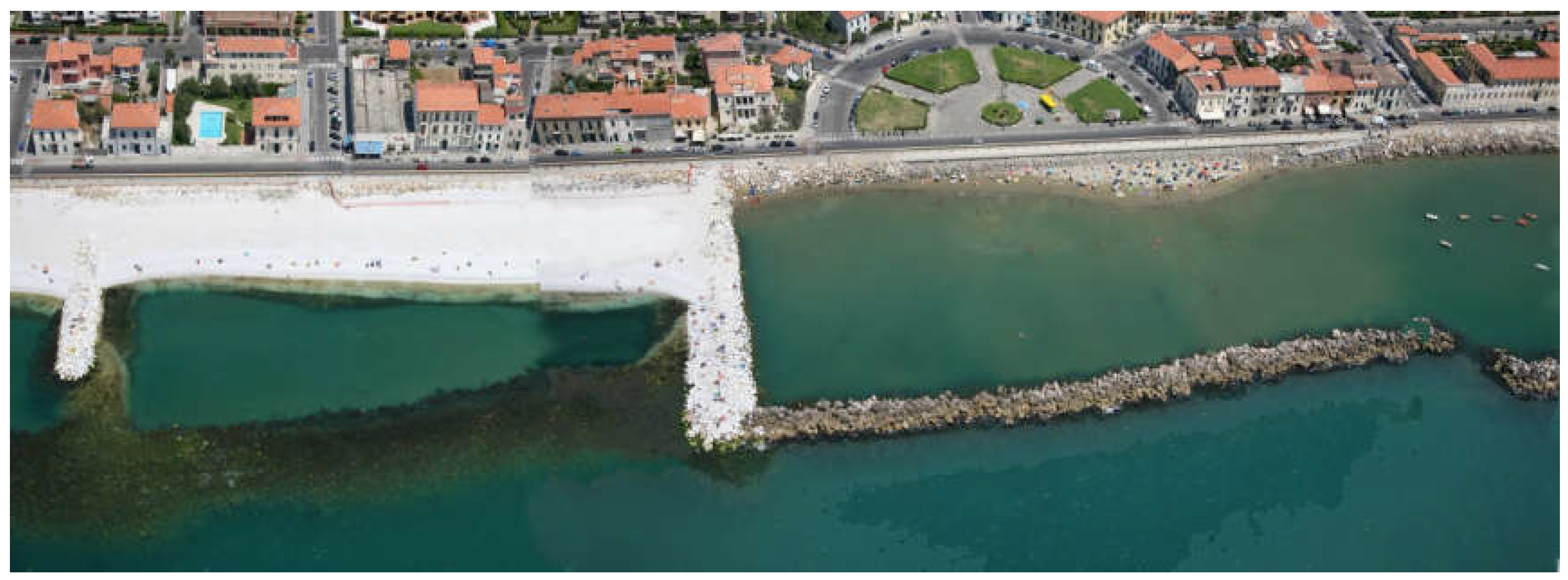
But it is the coast at Marina di Pisa, which gave origin to the first structure proliferation in this littoral unit. Maps dated 1878, 1907 and 1920 (
Figure 12) showed no structures in front of the town but analysing old photos and postcards, it is possible to observe perishable structures (permeable wooden fences and groins) on the beach fronting the recently built settlement, which can be dated to the very early 20th century (
Figure 13).
The 1928 IGM map shows several short groins on the first kilometre of coast south of the R. Arno. Ten years later a detached breakwater connected to an older groin appeared immediately south of the river mouth and in 1954 another detached breakwater was evident. At this time, the first kilometre of coast had a continuous revetment (
Figure 6).
These defences gradually evolved into a more structured project performed in the 1960s to arrive at ten detached breakwaters, some of which were connected to the coast with groins: each kilometre of coast was protected by 2.3 km of rock. It is in this period that detached breakwater length overpassed that of revetments in the study area (
Figure 6).
The shoreline position was fixed but erosion continued on the submerged profile: at the external foot of the detached breakwater a depth of 7 m was reached, both for the general sedimentary deficit and for basal scouring, as in Reference [
64]. These breakwaters become inadequate to protect the settlement and their elevation from 2.0 m to 3.5 m was postulated, when the need for softer shore protection structures was growing in Tuscany under the motto “Back to the beach” [
65]. A new project started with lowering of the old breakwaters to 0.50 m below mean sea level and widening their crest; a 30 m wide gravel beach was created to absorb the overpassing wave energy. Currently four of the ten breakwaters have been converted by transforming 940 m of emerged structures into submerged ones (
Figure 14).
On the southern side of the town, shore protection structures expanded towards Tirrenia, not to protect the road or the houses but to maintain the beach in front of the numerous beach establishments. It is not known how many defences were unauthorized but it is accepted that they did not follow a general project. Now detached breakwaters, oblique and shore-connected structures and traditional groins limit safe access to the sea, producing low quality water and they have transformed a sandy coast into a rocky one (
Figure 15). The value on this coast in terms of tourism income was strongly reduced and all this was done simply to support tourism.
Four kilometres north of the Arno River mouth (
Figure 16), the five detached breakwaters were built between 1962 and 1968 to defend Gombo beach, in front of the Presidential Villa of San Rossore (now part of a Regional Park). The house was more than 300 m far from the shoreline and only two huts were present on the beach: the project was carried out exclusively to maintain beach facilities for park employers more than for the Italian President.
However, results were limited and 20 years later only smooth salients were formed. In 1984 four out of the five breakwaters were elevated and extended: resulting immediately in four tombolos, which fitted well with model predictions of beach response to structures geometry [
66]. Longshore transport was interrupted by the tombolos and downdrift beach caused severe erosion; here the deepening of a spiral bay induced updrift erosion, destroying the tombolos and leaving the breakwaters too far offshore to be effective [
67].
In 2009 an artificial tombolo with geo-textiles was constructed to connect the fourth breakwater and two submerged groins, also these with geo-textiles, were built to the north to limit erosion [
15]. Such structures were quickly destroyed, very likely by the tree trunks brought to the sea by the R. Arno and transported northwards under the dominant winds and waves. Within the same project, the fifth breakwater was demolished, although, its elements can still be found on the sea floor. Meanwhile, a project to defend the northern lobe of the Arno River delta, retreating at a rate of 10 m/yr in the period 1997–2001, was carried out in 2001 comprising nine groins which were extended seaward with submerged segments for a total structural length of 1.3 km of structures. The total length of orthogonal structures on the study area reached 7.8 km. The need for this intervention, unusual in Italy, was not to protect settlements for tourist activities but to prevent further erosion which was connecting the interdune swales to the sea, thus causing the death of fresh water vegetation, which is one of the most relevant natural values of the Regional Park. Beach monitoring proved the effectiveness of the project [
68]. This represents an interesting case because shore protection structures were built to restore a natural habitat; elsewhere, for this purpose, structure removal is proposed [
69].
5. Conclusions
Shore protection structures have expanded greatly along the northern Tuscany coastline mostly following the developing tourist industry and under a policy of emergency intervention (
Figure 6). The early projects mainly aimed at defending coastal roads by revetments but within a sedimentary deficit framework, this invariably resulted in beach disappearances. Several projects were addressed all limiting the effect of previous ones, each never anticipating the erosion process and constructing structures in an updrift direction.
Coastal erosion was trigged by the sediment river input reduction, commencing from ‘two hot spots’ that is, at the mouths of the River Magra and River Arno.
At the River Magra mouth, coastal development took place later than on the R. Arno delta southern side and no protection works were initially carried out except emplacement of a detached breakwater to protect a coastal road (1928–1938). In the following years tourist beach use exponentially increased and, accordingly the necessity of maintaining and/or enlarging beach width, resulted in artificial islands, groins and detached breakwaters being built in a downdrift sequence producing the “domino” effect [
70].
On the left bank of the R. Arno mouth, at Marina di Pisa, the “new town” had to be strongly defended although tourism demanded a beach. After weak attempts of beach protection via short groins, a seawall and 10 detached breakwaters were built. Shore protection was extended to the south to satisfy beach tourist demand and ended only at Tirrenia, area of longshore transport convergence —where erosion never occurred (
Figure 1).
On the right-hand side of the R. Arno mouth, nature was untouched until 1300 m of land was lost; in 2001 emerged groins with submerged extensions were built to protect the Regional Park wetlands. A completely different approach was taken a few kilometres north, at Gombo, where detached breakwaters were positioned in the 1960s to defend the privileges of a few people (
Figure 16).
A further erosive hot spot was later introduced by man: Marina di Carrara harbour, which only anticipated and boosted the erosion process, expanding southwards from the River Magra mouth. Again, coastal road protection was the first reason to build defence structures, in this case revetments and later detached breakwaters. Downdrift erosion, together with beach tourism activity, brought first groin emplacement and later submerged breakwaters.
Detached breakwaters had a gradual rise and, in 1965, their total length reached that of the previous structures. Their imposition is also a consequence of a school of engineers working for the Italian Ministry of the Public Work, who deemed that only a reduction of wave energy was able to protect the coast. In the same years, several coastal segments in Italy were protected in this way, for example, detached breakwaters number more than 240 over 23 km of coast at Pescara, Adriatic Sea [
15].
Groins (after the transient case of Marina di Pisa in the 1920s) were not frequent along this coast until the 1980s, being limited to those of Marina di Massa; but later they experienced an accelerated expansion and in 2011 their total length was greater than that of detached breakwaters. However, the last project at Marina di Massa, aimed at reducing the landscape impact of defensive structures and increasing beach quality, which resulted in a small decrease in their total length (
Figure 6).
The main recent change in the coastal defence philosophy was the shifting from emerged to submerged structures. The latter slowly started in 1965 and today submerged detached breakwaters and groins reach 60% of the length of their emerged equivalents (7940 m vs. 13,230 m). Decision makers are highly influenced by economic stakeholders since these represent a significant part of electoral voters and the answer to beach erosion is often a compromise between the best technical solution and the most appealing one for the tourist industry. At Marina di Massa and Marina di Pisa all interventions were designed under a local perspective, without a general view of the processes at work along the littoral cell and a clear knowledge of river sediment input, which is essential in any adequate and long-term coastal management plan [
71]. Under stakeholders’ urging, heavy projects were executed when updrift defences had a negative influence. This study evidences as sediment bypassing could have been implemented at most important harbours and softer solutions could have been adopted starting from stable sectors and moving towards eroding areas but this requires a long-term strategy, incompatible with the life-time of political officers.


