Irrigation in the Ili River Basin of Central Asia: From Ditches to Dams and Diversion


1
Center for European, Russian and Eurasian Studies, Michigan State University, 427 North Shaw Lane, East Lansing, MI 48864, USA
2
Center for Global Change and Earth Observation, Michigan State University, 1405 South Harrison Road, East Lansing, MI 48824, USA
3
Department of Plant, Soil and Microbial Sciences, Michigan State University, 1066 Bogue Street, East Lansing, MI 48824, USA
4
School of Aeronautics and Astronautics, Sun Yat-Sen University, 132 East Waihuan Road, Panyu District, 510006 Gaungzhou, China
5
Xinjiang Institute of Ecology and Geography, Chinese Academy of Sciences, 830011 Urumqi, China
6
Faculty of Biology and Biotechnology, Al-Farabi Kazakh National University, 71 Al-Farabi Avenue, 050040 Almaty, Kazakhstan
*
Author to whom correspondence should be addressed.
Water 2018, 10(11), 1650; https://doi.org/10.3390/w10111650
Submission received: 15 October 2018
/
Revised: 2 November 2018
/
Accepted: 9 November 2018
/
Published: 14 November 2018
(This article belongs to the Special Issue Water-Food Nexus: Fish Resources and Lake Ecosystem Vulnerability)
Abstract
:Central Asia’s Ili River is fed by mountain streams that flow down into an isolated and arid basin that today is shared by Kazakhstan and China. Agriculture in the basin is dependent upon irrigation, which was practiced as long ago as the Iron Age, when early pastoralists constructed ditches to channel water from streams onto nearby fields. Irrigation had become much more common by the 18th century, when the region was controlled by the Dzungarian Khanate. The khanate was toppled by the Qing Chinese in the 1750s in the first of a series of confrontations that destroyed and then rebuilt the basin’s agricultural economy. The region has since been dominated by a succession of Chinese and Russian (and later Soviet and independent Kazakh) governments, each of which recognized the essential role of irrigated agriculture in maintaining control. Thus every cycle of destruction led to reclamation of new lands, resettlement of farmers and upgrading of infrastructure to expand irrigation. This allowed an impressive diversity of fruits, vegetables and field crops to be grown, especially on loess soils of the more fertile upper basin, where tributaries could be easily tapped by gravity flow. Many of these tributaries were entirely diverted by the 19th century, so that they no longer reached the Ili. Large scale irrigation commenced in the 1960s, when the Soviets built Kapchagai dam and reservoir in the lower part of the basin and installed pumps to raise water from the Ili River onto nearby reclaimed sierozem soils, mostly for cultivation of rice. China later constructed a cluster of small- and medium-sized dams that enabled expansion of agriculture in the upper part of the basin. Many irrigated areas along the lower reaches of the Ili in Kazakhstan have been abandoned, but irrigation in the upper basin continues to expand. Declining soil fertility, salinization, pollution, insufficient inflows and adverse economic conditions currently challenge irrigation across the entire basin. Investments are being made in new technologies as a means to sustain irrigated agriculture in the basin, but it remains to be seen if these strategies will be successful.
1. Introduction
The Ili River passes through some of Central Asia’s most arid landscapes and nourishes a complex and fragile ecosystem that has sustained human life for centuries [1]. The river arises from three main feeder streams, the Kash, Künes and Tekes Rivers, which contribute 29%, 15% and 56%, respectively, of the inflows that create the Ili [2]. These glacier-fed waterways descend from the high Tian Shan mountain system that surrounds the upper valley like a vice, with the Borohoro and Dzungarian Alatau ranges to the north and the Halik, Trans Ili Alatau and smaller Ketmen ranges on the south. The Ili River flows in a westerly direction for 1439 km from its point of origin, exiting from China’s Xinjiang Uygur Autonomous Region and extending into Kazakhstan.
The river is heavily reliant on surface inflows from tributaries that course down from the flanking mountains along much of its length, especially in China. Inflows are rhythmic, with peak flows experienced during the spring and summer seasons of glacier melt and with lower flows characteristic of the remaining months of the year [3]. The river eventually forms a sinuous 9000 km2 delta before it empties into the western arm of Lake Balkhash, which covers a total of more than 16,000 km2 and is one of Central Asia’s largest inland bodies of water [4]. The Ili River basin is shared almost equally by China and Kazakhstan and encompasses 115,000 km2 of area, providing 75–80% of the total inflow into Lake Balkhash [5]. The remaining inflow is supplied by minor rivers that empty into the eastern arm of the lake. Lake Balkhash is endorheic, with no outlet to the sea. Sediment, salts and other solutes delivered to it accumulate as the water evaporates and enters the atmosphere.
The landscape of the Ili River basin becomes progressively drier from east to west. Even at Yining, in the upper valley, average annual precipitation is only 249 mm; this declines to 223 mm as the river enters the Saryesik Atyrau desert near Kapchagai in Kazakhstan and is a scant 116 mm at Balkhash city on the north shore of Lake Balkhash [6]. Western explorers who visited the area more than 125 years ago noted that the absence of rainfall along the river precludes agriculture unless irrigation is available, but they also observed that the soils and other environmental conditions—especially those in the upper valley—are ideal for crop growth [7,8,9,10,11]. Water has thus long been recognized as the limiting factor for farming in the region.
The Ili River has become the subject of intense recent interest from the standpoint of environmental preservation, balancing competing uses for water, energy and food, and avoidance of transboundary conflict over resources [12,13,14,15]. Irrigation, which expanded significantly in the 20th and early 21st centuries, increasingly competes with other uses for consumption of a scarce and limiting resource. Irrigated agriculture is recognized as a contributor to unsustainable levels of water withdrawal from the river and as a significant source of pesticide and fertilizer pollution. This threatens Lake Balkhash and the river delta’s unique tugai ecosystem, which was recently accorded protection under the Ramsar Convention.
Although the relationship between irrigated agriculture and environmental threats to the Ili River is undisputed, irrigated agriculture along the Ili has not received the attention given to that along the Syr Darya and Amu Darya Rivers to the west, which feed the shrinking Aral Sea and have triggered widespread environmental destruction [16]. Unsustainable diversion of Ili River water has nevertheless drawn attention to the future of the surrounding basin. Interest in diversion of the Ili River basin’s water for agriculture has been rather narrow, focusing on just three main issues: (i) The effects of construction of Kapchagai dam and reservoir by the Soviets in the late 1960s, (ii) the consequences of the dissolution of the Soviet Union in 1991 and the coincident emergence of Kazakhstan as an independent republic and (iii) the implications of recent dam and reservoir construction by China. These issues are considered here within a broader, more comprehensive spatial and temporal context. We begin by considering the rich historical foundation for the development of irrigation in the region and then provide details on soils, cropping systems and irrigation infrastructure. We conclude with implications from more recent data, including observations and experiences from well-studied irrigated areas and a prognosis for the future of crop-based agriculture along the river.
2. Early Development of Irrigation in the Ili River Basin
2.1. Origins
Central Asia, including the Ili River basin, is the traditional home of nomadic herders who drove their animals to meadows on the region’s steppes during the summer and assumed a sedentary lifestyle only during the cold winter months, when forages were no longer available in summer pastures [17,18,19]. Crop-based agriculture was long considered to have been a more recent development, but recent evidence has blurred the distinctions between economies based on herding and farming, in the process pushing back the earliest date of known cultivation of crop plants in the region. Some herding communities in the catchment of southeast Kazakhstan’s Karatal River (one of the minor feeder rivers for Lake Balkhash) engaged in a mixed pastoral-agricultural economy as early as the Bronze Age, more than 2000 years ago [20,21]. Iron Age pastoralists (410–150 BC) also took advantage of the rich alluvial fan created by the Talgar River, a feeder stream that descends from the Tian Shan Mountains and makes its way northward toward the Ili River in present day Kazakhstan [22]. Here they cultivated a mixture of crops, including broomcorn and foxtail millet, hulled and naked barley and wheat [23].
Rainfall would have been nominally sufficient to grow these crops, but precipitation is intermittent and unpredictable and so it seems certain that irrigation channels were created to divert water from the seasonally surging river to the nearby fields [17,23]. Conditions are not favorable for preservation of such sites in Central Asia, but there are fragmentary reports of remains of ancient irrigation structures in the region [20,24], including at sites just upstream of the Ili River delta [25] and along the Tekes River in present day China [26]. Although time has obliterated much of the physical evidence of ancient water diversion for crops in the Ili River basin, there is evidence that early pastoralist-agriculturists took advantage of the seasonal flow of rivers descending from the mountains, digging simple gravity-fed irrigation channels so that water could flow onto fields [22,27,28].
Pastoralism nevertheless predominated for many years, but beginning in the 18th century and continuing until the present, nomads found themselves in escalating conflict with political forces that favored settled agriculture and thus prioritized irrigation. Kazak [29] and Wittfogel [30] both contend, with justification that is still relevant today, that of all factors, a functioning irrigation system is the most sensitive barometer for political security in the region. Indeed, each wave of political instability in the Ili River basin is the story of irrigation systems that were destroyed only to be rebuilt as quickly as possible and then destroyed again when political instability recurred.
2.2. Intensification of Irrigation during the 18th and 19th Centuries
The rich political and economic history of the Ili River basin has been studied in detail by historians, political scientists and others [27,31,32,33,34]. For our purposes, it is sufficient to note that the collapse of Genghis Khan’s Mongol Empire in the late 13th century set the stage for control of Central Asia by a constellation of political entities termed khanates that were ruled by his descendants. These entities existed with borders that were not firmly fixed. The last of them was the Dzungarian Khanate, which arose in the early 17th century and grew to encompass the entire Ili River basin. The Dzungars were for the most part nomadic, but nearly 77,000 ha of land, much of it in the Ili River Valley, was under cultivation by the mid-18th century, just as the Dzungarian Khanate entered its last days [35]. It was toppled in the 1750s by the Qing Chinese, who feared instability along their western frontier and sought to secure the region [36,37,38]. Most of the area was occupied in 1754 by the Chinese, who within five years consolidated their authority. Unwilling to face the possibility of future unrest, the victors imposed military rule and exterminated the Dzungars, in the process destroying the Ili Valley’s agricultural economy. The Qings then set out to confront the problem of supplying the garrisons that had been dispatched to the newly occupied lands with food at minimal cost to the distant central government. This triggered a wave of rapid expansion of irrigation and a concerted effort to revive and develop settled agriculture.
The steppe land that the victorious Qing Chinese sought to reclaim is confined to a belt of fertile soils that skirts the mountains, separating them from the Ili and its main tributaries (Figure 1). Here the highlands give way to chestnut soils that are succeed by zones of loamy soils considered to be good for agriculture [7,8,11,36,37,39,40,41]. The soils of the steppe nevertheless contain stones and there are unproductive areas of alkalinity and sand dunes, as well as swamps, salt swamps and pools adjacent to the river. The principal arable zone extends along the Ili River and widens as it reaches the western frontier [37]. Much of the course of the Kash River is bracketed between narrow gorges that are unsuitable for farming, but several patches of land along the Künes and Tekes River are arable (Figure 1). A few small areas in the foothills of the western Ili Valley are even suitable for dryland farming in years of favorable rainfall [42], as are remote, higher elevation areas of the upper Tekes catchment [43], but these areas are of limited significance for food production. The steppe lands are fed by a dense network of 120 smaller, often seasonal streams that flow down from the mountains toward the four principal rivers of the basin. Some of them reach the Kash, Künes, Tekes and Ili Rivers, especially in mountainous areas and along the north bank of the Ili River, but others enter the steppes and culminate in alluvial fans that dry up and provide little if any inflow into the main rivers.
The Qing Chinese understood that these huge tracts were available for farming [44,45] and indeed, irrigated agriculture had already been underway in so-called steppe oases adjacent to alluvial fans created by some of the small feeder streams [35]. The Qing conquest of the 1750s nevertheless marks the real onset of irrigation in the area [37]. The Chinese government immediately set out to resettle the former Dzungarian lands. A diverse group of settlers was brought into the depopulated Ili River basin, sometimes under coercion and other times with incentives such as free land, seed and farm implements. The new residents included Uygurs (known locally as Taranchis, they were experts at oasis agriculture), convicts from the east, Chinese civilian immigrants and soldier-farmers. Among the latter were the Sibos (also known as the Xibes) and the Solons, both of which exist today as recognized minority populations. The latter two groups received prime lands on the south and north side, respectively, of the Ili River, west of present day Yining [46].
All of the settlers were expected to construct irrigation channels and begin cultivating crops. The Sibos immediately set out to repair an existing irrigation ditch and soon had a modest 667 ha of land under cultivation [47]. Other ditches and smaller canals were built [34,45], so that by the early 19th century, large scale irrigation infrastructure was underway. The Sibos excavated a 100 km canal between 1802 and 1808; it allowed 5300 ha of farmland south of the Ili River to be irrigated [41]. Canals, some up to 70 km in length and spanning rough, mountainous terrain, were later constructed at immense human cost to divert water from the Kash River to lands and tributaries north of the Ili [7,8,44]. Many of these minor streams had formerly emptied into the Ili but now were consumed for irrigation of steppe oases. The large new canals allowed for expansion of irrigated areas, the construction of a network of smaller canals and the establishment of new settlements on both sides of the Ili River.
The results of this activity have been compared to the taming of the North American Midwest by the United States in the mid-19th century [34]. Whereas in 1761 only about 3400 ha of land was cultivated in the Ili River Valley [37], 14,000 ha were cultivated in 1777 [44]. By the early 19th century and as the result of the land clearing efforts of 200,000 civilians, more than 120,000 ha of land in the valley had been reclaimed—an immense increase in just a few decades.
Radloff [11] visited the area in the 1860s and describes a nearly continuous landscape of orderly fields that were crisscrossed with perpendicular arrays of primary and secondary ditches. These were equipped with gates that could be opened and closed to regulate flow. Furrows were up to 1 m deep and constantly renewed to remove soil that had washed into them. Water was also diverted to ponds surrounding the houses and used to maintain orchards and forests [8]. The farms were separated from one another by trees, mainly poplar, elm and willow [48]. By all accounts, the landscape was orderly, productive and attractive.
The availability of water allowed the settlers to begin cultivating a diverse and impressive array of crops (Table 1). Most were consumed as foods, but others such as opium, tobacco and barley (which was used as animal feed) met other needs and were sometimes traded. All of this irrigation infrastructure, which had been constructed at such great cost, was nevertheless being neglected by the mid-19th century as the region endured a second period of unrest [34]. The trigger was sectarian divisions between the various ethnic groups that had arrived after the defeat of the Dzungars but failed assimilate. The conflict spread to the Ili Valley in 1863 and raged until 1871, when Russia entered the region from the west and occupied the entire valley in an effort to secure the frontier along its still ill-defined frontier with China [11,35,49,50].
Russia’s advance into the upper Ili River Valley corresponded in time to the first serious interest in irrigation on the part of the czars [53]. Russia had in fact been encroaching into Central Asia for many decades as its farmers moved onto traditional Kazakh grazing lands. These settlers came from the north and west, founded its first colonies in the Ili basin about 1856 [54] and soon were competing with nomads for access to land and water [34,55]. Catherine the Great, who believed that nomadism conflicted with trade in the area, went so far as to dispatch Russian farmers to the region in 1764 in an ill-fated attempt to instruct Kazakh nomads on agricultural techniques [32]. Russia consolidated its control of the lower Ili River basin in 1854 and began struggling to settle its nomadic Kazakh subjects, with little success. Russian settlers were consequently given preferential access to irrigable land. By the mid-1860s, the piedmont valleys near Fort Verny (present day Almaty) were covered with fruit trees [56], but there was comparatively little farming activity on the more arid and poorer quality land near the Ili River. Indeed, the frontier region along the Ili between Russia’s Chilik River and the Chinese border was described as little more than sand dunes [7,54].
The Russian occupation of Chinese territory in the Ili River valley proved to be short-lived. After the Russians withdrew in 1881 [29], the Chinese returned to find that the valley’s infrastructure had been ruined [57]. The Russian occupiers had managed to cultivate grain crops, as well as introduce new crops such as potatoes and the Sibos had been able to construct a few new canals [47]. But irrigation systems were in a state of general disrepair [11,46] and many farmers had been driven away. Western visitors described a landscape dotted with dried up canals, abandoned fields and withered forests, including a vast expanse of dead trees in a plantation near Horgos [8,11]. As was the case a century earlier, the returning Chinese prioritized agriculture. Decommissioned troops were encouraged to remain and take up farming [58] and irrigation infrastructure was restored. Another cohort of Uygur farmers was also allowed to move onto empty lands. This accelerated agricultural development in the Chinese sector but also added to the already complex ethnic makeup of the region [57].
3. Intensification of Irrigation after 1900
3.1. Russia and the Soviet Union
In 1890 Russia dispatched the eminent agronomist A. A. Kaufman to investigate the Central Asia’s irrigation potential, but in contrast to China and with the exception of cotton production near the Aral Sea, the Czars did not move aggressively to develop irrigated agriculture in the region [17,32]. It nevertheless has been estimated that as of 1900, the Russians were cultivating about 300,000 ha of land in the Ili River basin [59], much of it irrigated from streams and smaller rivers descending from the mountains. Machatschek [60], who visited Lake Balkhash and the delta region in 1911, saw evidence of old settlements and irrigation, but shifting sand made irrigation difficult and there were few farms.
Interest in irrigation was rekindled in 1912, when Moscow set up a scientific commission to examine the feasibility of large scale irrigation in the Ili River basin [29]. This body labored for four years, concluding that up to 1 million ha of land could potentially be developed on the Russian side of the border. This would require either construction of a large canal on the Chinese side of the border to deliver water by gravity or the installation of pump stations on the Russian side. Ideally, the pumps would be powered with coal from the extensive deposits near the river in China. Should neither of these expensive options prove feasible, the commission concluded that new croplands would be limited to about 100,000 ha of land that could be irrigated by increased diversion of feeder streams descending from the mountains.
The Russian revolution of 1917 shifted attention from Russia’s plans to irrigate the lower Ili basin, wreaking havoc on agricultural production in the area, much as had been the case during previous centuries on the Chinese side of the border. Far from undergoing expansion as called for in the 1912–1916 plan, the irrigated land area along the Ili River was soon reduced by two-thirds relative to the turn of the century [61,62]. The new Soviet government nevertheless wanted agriculture to become more efficient and scientific and so it designed a number of irrigation projects, only a few of which eventually materialized [29,32]. Irrigation recovered somewhat, so that by 1939, the irrigated area in the Ili River basin had increased to nearly 200,000 ha [59]. This was accompanied by a shift in cropping patterns that reduced the amount of land devoted to grain production and elevated production of animal feed for the region’s important livestock industry [62].
Although major expansion of Soviet irrigation began in the 1950s [63], the construction of Kapchagai dam and reservoir is by far the 20th century’s most important irrigation project in the Ili River basin. The project grew out of the Soviet Union’s need for additional electrical power and pre-war estimates that up to 1 million ha of land in the basin could be opened up for irrigation, should water be made available [2,61]. In 1926–1927 experts from Tashkent were deputized to re-evaluate the Ili basin’s irrigation potential. They concluded that up to 500,000 ha could be irrigated, including 45,000 ha for rice, an important crop well suited for cultivation on the region’s saline soils [64]. Although rice cultivation began on a limited basis in 1929 [2], it took four decades until the dam was constructed. This was a period of increased Soviet prioritization of agriculture and irrigation [32] and so a number of plans and counter plans were prepared and evaluated, including one impractical scheme that envisioned a 3.5 million ha area for irrigation. The Soviets initially accepted projections of just 430,000 ha for irrigation, including 100,000 ha for rice [64], but as the reservoir was filling in the 1970s, officials increased their estimates of the arable potential for rice to 257,000 ha. The residual lands were assigned to production of vegetables, fodder and grain crops [65].
Irrigation in Kazakhstan’s portion of the Ili River basin was already expanding prior to commissioning of Kapchagai dam in late 1969 and the trend continued throughout the Soviet era (Figure 2). The irrigated area increased from about 300,000 ha in 1970 to more than 400,000 ha in 1990 [2,6,62], even though for environmental reasons, the reservoir was never filled to its intended capacity [4]. Maps and available statistics from the 1980s confirm that the vast majority of the irrigated cropland at that time lay upstream of the reservoir in piedmont areas [2,25]. Most of the water was withdrawn from rivers originating in the Tian Shan Mountains and not from the reservoir or the Ili River. The completion of the Big Almaty Canal in 1982, for example, expanded withdrawals from the Chilik River basin, doubling the amount of 150,000 ha of land that had been irrigated previously [2,62]. Less than 20% of the irrigated land area in 1986 was located in four districts downstream from the dam and indeed, irrigation along the lower Ili River never became a substantial fraction of the total (Figure 2).
3.2. China
Early 20th century travelers described a landscape of hamlets along the Chinese reaches of the Ili River, with adjoining fields, rice paddies and tracts of trees and grazing lands [46]. The revolution of 1911–1912 ended the Qing dynasty and ushered in a new republic, once again disrupting agriculture and leaving many of the Ili River Valley’s fields untended [42,66]. The Sibos and Solons nevertheless survived the unrest and were able to prosper as farmers in the valley [36]. Irrigation and land reclamation were prioritized during the early years of the republic, but political instability caused irrigation in Xinjiang (separate figures are not available for the Ili River valley) to fluctuate greatly: from 802,000 ha in 1918 to 309,000 ha in 1933, 996,000 ha in 1942 and 373,000 ha at the inauguration of the People’s Republic in 1949 [58]. Irrigation research facilities were nevertheless established and dozens of new water conduits were opened and repaired such that by 1944 Xinjiang possessed 944 main irrigation canals and 2.335 branch canals, many in the Ili River valley [67].
The Ili region had 216 canals with a total length of 766 km as of 1944; just five years later, the corresponding figures were 260 canals and 4989 km in total length [37]. Rice and melons were grown in the Ili Valley oases and soybeans, green beans and millet were also harvested during this period [36]. When the Communists assumed power in 1949, they discovered that history had repeated itself: Xinjiang’s irrigation works were in need of repair and much cropland lay fallow [58]. Irrigation infrastructure was once again restored, in large part by the Xinjiang Production and Construction Corps (XPCC), which was established in the early 1950s and staffed with demobilized troops [50,62,68,69]. Ten thousand trunk irrigation canals were in place by 1959 and by 1960, the XPCC had established 182 state farms in the valley. New sluice gates were installed in 1964, benefitting 150,000 ha of land in the Ili Valley and two years later, a new 25 km canal was blasted through the rocks in divert Kash River water for irrigation of 175,000 acres [37]. The amount of land under cultivation in Xinjiang consequently increased from 1.2 million ha in 1949 to over 3 million ha by the early 1970s, [69], yet as of the late 1980s, the cultivated area in the Chinese portion of the Ili River Valley was only about 300,000 ha, essentially all irrigated [62]. Thus by the dawn of the last decade of the 20th century, the scale of irrigation in the Chinese and Soviet portions of the basin was roughly equivalent. This was about to change.
3.3. Irrigation Responds to Modern Geopolitical Events
The modern era ushered in two geopolitical events that reinforce one another, granting comparative irrigation advantage to China. The first was the collapse of the Soviet Union in 1991 and the appearance of Kazakhstan as an independent nation. The new republic found itself suddenly uncoupled from Moscow, which had previously expanded irrigated agriculture by providing more and more inputs [70]. Moscow had also balanced the Soviet Kazakh Republic’s water, energy and food needs with those of its neighbors within the Soviet Union [71,72,73]. Independent Kazakhstan struggled to adjust to market forces and stabilize its economy and agriculture, which was not a top priority, suffered in this process [74]. State support for farms was terminated, land was privatized an water fees were introduced [75,76,77]. Irrigation in the Ili River basin consequently plummeted, dropping from about 400,000 ha at independence and fluctuating between about 200,000 and 300,000 ha in the years leading up to 2006 (Figure 2). Many irrigation districts, especially those dependent on electricity to power pumps, were abandoned entirely and this accelerated decay of infrastructure [75]. Irrigation districts fed by gravity flow, including those below the dam and just upstream from the delta, fared better, but they, too, were reduced in size [78].
The second important geopolitical event occurred almost coincident with the dissolution of the Soviet Union, as the economy in China began to rapidly expand and diversify [79]. This drew attention to the upper Ili River Valley, with its rich natural resource base that included untapped sources of water [80,81]. Expansion of agriculture in the Xinjiang Uygur Autonomous Region was codified in a series of formal government plans [82,83] and has been aided by the designation of the valley as the route for the main overland transportation and logistics corridor of China’s Belt Road Initiative [84,85]. There is little consensus on the impact of these developments on irrigation in the Chinese sector of the basin and even less on the amount of land that is currently being irrigated (see below). Uncertainty about the numbers notwithstanding, it is clear that water withdrawals to enable the rapid expansion of irrigation on the Chinese side of the border has more than offset contraction of irrigation and reduction of withdrawals in Kazakhstan [86,87,88]. This is leading to anxiety that Ili River inflows into Kazakhstan are being reduced to levels unable to sustain the delta and Lake Balkhash [43,89]. These concerns are exacerbated by the transboundary nature of the basin and have led to substantial and ongoing debate about water, its role in the future of the ecosystem and the need to avoid conflict [12,13,90].
4. Characteristics of the Irrigated Areas
4.1. Edaphic Factors
Development of crop-based agriculture in the Ili River basin requires irrigation, which in turn imposes a whole set of agronomic requirements beyond those governed by political factors and other issues such as access to markets. An adequate source of water must be available throughout the growing season. Soils must to be fertile and well-drained to prevent buildup of salts and other contaminants. Until relatively recent times, land had to be situated so that gravity could do the work of water distribution. The region’s desert sands, although plentiful, fulfill none of these requirements. On the other hand, the delta zone and land along the banks of the Ili River fulfill the most basic requirement by offering easy access to water, but these areas are swampy, prone to periodic flooding and subject to perturbations as the riverbed shifts over time [42,91,92,93].
Early farmers thus turned their attention to the extensive zones of wind-blown loess that carpet the river terraces and foothill plains near the basin’s rivers [94,95]. Loess is widespread in the Chinese portion of the basin, but it also appears along the northern slopes of the Trans Ili Alatau mountains and in the Sharyn River basin of Kazakhstan, eventually giving way to desert sands along the lower reaches of the Ili River between Kapchagai Reservoir and Lake Balkhash [96]. The basin’s climate favors conversion of loess to a class of soils termed sierozems [97]. These soils have good physical properties [98] and they can also be formed from materials deposited by running water in areas such as floodplains, where loess may be absent [94].
Sierozems constitute the bulk of irrigated soils in the Ili River basin [99,100]. They are relatively fertile and thus suitable for agriculture if water is provided and steps are taken to maintain fertility [101]. These soils nevertheless often overlay zones of salinity and so adequate drainage is an issue, especially under conditions of irrigation, which can cause salts to migrate to the soil surface and accumulate. Sierozems also are often intermingled with undesirable solonetz and solonchak soils, which are strongly saline and of marginal value for crop production [96,102,103,104]. These latter soil types are characteristic of the lower Ili River basin, where solonchaks and other interfering soils can constitute more than 25% of the land in irrigated floodplain areas [97,105]. Salinity is consequently a major and ongoing challenge for irrigation across the basin, both in Kazakhstan and China [102,104,106,107,108,109].
4.2. Irrigation Areas in the Upper Ili River Basin
Although there are several 19th century eyewitness descriptions of irrigation sites along the Ili [7,8,11,39], as well as at least one map of ancient canals and dams [34], Ludwig Golomb deserves credit for the most detailed physical and analytical descriptions of traditional irrigation works in the area. A Christian missionary, Golomb [40,42] lived and worked in the Chinese portion of the Ili River Valley from 1922 to 1939, where he took photographs, made extensive observations on everything from snowstorms to the use of dowsing rods and published a series of detailed sketches and maps. Since much of the steppe was sparsely populated with decaying farms and irrigation systems, he turned his attention to the valley’s most intensive irrigation sites, including oases surrounding larger settlements at Yining (then called Kuldja) and Huocheng (then called Suiting), as well as smaller nearby oases.
Early 20th century oases were still dependent on gravity and so most could not draw their water directly from the Ili River, which was largely inaccessible because of the depth of the riverbed [42]. Canals, some then in use and at least one abandoned, also diverted irrigation water from the upstream Kash and Tekes rivers (Figure 3A) less is the smaller feeder streams coursing down from mountainous areas to the north and the south that were almost totally consumed for irrigation, thus depriving the upper Ili River of as much as 11% of its inflows [2]. The irrigated fields were of fertile sierozem soils formed from loess that overlies gravel ridges on both sides of the Ili. The gravel usually provided good drainage to prevent accumulation of salts, but if drainage proved to be inadequate, the fields were flooded and then leached. Water was diverted from the streams via a series of hand dug canals and channels, some as much as 8 meters deep, that had been meticulously laid out to optimize water flow and distribution. Artificial waterways were open during the summer but blocked off in the winter, so that the streams could flow naturally part of the year.
Golomb [42] provides detailed descriptions of the government’s perspective on irrigation, the community’s role in determination of water rights and the traditional methods used to lay out, construct and maintain irrigation infrastructure. He also grants us insight into the crops grown on irrigated lands almost 100 years ago. Melons and watermelons were produced in abundance and although apples, cherries and plums were common, there were no other fruits. With the exception of carrots and onions and few other vegetables such as tomatoes, cucumbers, eggplants and peppers, vegetables were also absent. Bread wheat and rice were ubiquitous and the Russians had introduced rye, oats and tobacco to the mix of traditional Chinese field crops that included barley, corn and sorghum. Rice was cultivated in swampy areas, including some on the banks of the Ili River, but most of the massive volume of Ili River water flowing past the settlements remained untapped.
The irrigated zones of the 1920s and 1930s have grown and coalesced over the years, so that the area studied by Golomb [42] is now a single, more or less continuous region characterized by irrigated fields that interconnect cities, smaller towns and associated infrastructure (Figure 3B). Newly reclaimed irrigation areas have also appeared, but there is uncertainty about their true extent. According to official statistics, about 184,000 ha were irrigated in the upper Ili Valley as of 1995 [43]; this area rose to just less than 300,000 ha as of 1998 and remained relatively constant until 2006 [62]. On the basis of detailed analysis of remote satellite imagery from the years 1976–1977 and 2000–2001, Christiansen and Schöner [43] concluded that these and other official figures are underestimates. Their measurements showed that the rate of increase of irrigated land area during the last quarter of the 20th century was about 4,000 to 6,000 ha per year and that the total as of 2000–2001 was as much as 700,000 ha.
Using Landsat-7/Enhanced Thematic Mapper (ETM) + imagery, we have mapped the spread of irrigated cropland in the upper Ili River basin from 2000 to 2015 (Figure 4). Annual rates of expansion during this period varied between 7000 and more than 18,000 ha (Figure 5). This growth added 181,507 ha to the 1.06 million ha of irrigated cropland that we calculate existed at the turn of the century and corresponds to a 17.1% increase over 15 years. Our remote imagery-based calculation for 2015, 1.24 million ha, corresponds well to statistical estimates of irrigated land area [12] and provides important new spatio-temporal information. Most of the increase was concentrated in a widening band in the western part of the area, south of the Ili River and close to the border with Kazakhstan, but expanded irrigation is also evident further east along the Ili River and in areas near the Kash River. A wide variety of crops are currently grown in these irrigation areas: sunflowers, sugar beets, soybean, wheat, rapeseed, maize, cotton and vegetables [12,108]. As of 2000–2001, more than 21,000 ha were devoted to rice, cultivation of which was centered on both sides of the Ili River below Yining but also occurred upstream as far as the lower reaches of the Künes River [43]. Areas devoted to maize, cotton and rice all significantly increased between 2004 and 2010.
Eight major dams, all on the Ili’s upstream tributaries in China (Table 2), are sources of irrigation water and in many cases hydropower [89]. Dozens of smaller reservoirs have also been built in the Chinese territory of the Ili River basin [109]. As of 2012, the total reservoir capacity on the Chinese side was estimated to be 4893.6 million m3 [110], roughly one-third of that represented by Kapchagai Reservoir in Kazakhstan (Table 2). These impoundments nevertheless are already influencing seasonal flows into the upper Ili River [86,87]. Irrigation areas in China also receive water from wells [107,111,112]. The groundwater level is elevated during the growing season in regions where wells are dense, to the extent that in some areas near the Ili River, it has almost reached the surface [112]. Salinity levels as high as 30 g/L have been recorded at some sampling points.
4.3. Irrigation Areas in the Lower Ili River Basin
The lower Ili River basin contains some of the main irrigated areas of Kazakhstan [113]. These areas are of two types: Those with inflows from streams originating in the mountains that flank the Ili River and those that draw water from the river itself (Figure 6). Most of the areas are of the former type (Table 3). Although there is a paucity of information on the water budgets of most of these sites, we know that they vary greatly in efficiency of water use and are fed by a combination of small streams and moderately sized rivers. These descend from the mountains and fan out onto sierozem soils that are not unlike those used for irrigation in the upper basin [95,99,100]. The smaller rivers and streams have flow rates characterized by significant temporal variability [114]. They occasionally reach the Ili under natural conditions, but many simply evaporate on the plains and disappear. Inflows from several larger Ili tributaries, including the Chilik and Sharyn rivers (245 and 427 km in length, respectively), are also used for irrigation. These rivers each transport a significant volume of water (on average about 30 m3/s) from the mountains and create deltas before merging with the Ili [115].
Although irrigation near Almaty was extensive by the middle of the 19th century [56], most of the mountain rivers lacked significant engineered irrigation infrastructure as recently as the 1970s. Water was simply diverted onto the fields, where it spread by gravity. This changed in 1967 with the construction of a dam on the Kurty River to create a reservoir as a source of irrigation water. Then in the 1980s, the Chilik River was impounded to create Bartogai Reservoir as a source of hydroelectric power and irrigation water. The reservoir stores water in the winter and releases it to the Big Almaty Canal during the summer [62]. The canal, which is concrete-lined and engineered for gravity flow, runs westward along the front of the Trans Ili Alatau mountains, providing a dependable source of water to feeder channels leading to irrigation sites. Several of these sites have been mapped in detail to show the configuration of primary and secondary canals, as well as smaller ditches [77]. Commissioning of the Big Almaty Canal led to an initial doubling of the amount of irrigated land, to more than 300,000 ha, but the extent of the irrigated area was significantly reduced post-independence [62]. Areas supplied by the canal are now used for cultivation of a mixture of field crops (rice, maize, sugar beet, soybean, alfalfa), as well as vegetables and fruits [2,77].
Construction of Kapchagai dam in the late 1960s made it possible to harness the Ili River and use its waters to irrigate areas that are more distant from the mountains, in arid zones lacking windblown loess soils [95]. These irrigation districts lie in or near the floodplain of the river’s lower reaches (Figure 6) and consist of sierozems mixed with poorer soils and other undesirable features such as sand dunes. Although irrigation of the largest district at Akdala relies on gravity, the other two districts (Table 3) represent attempts to irrigate with water pumped from the reservoir (at Shengeldy) or the river (at Kerbulak). Neither of the latter two sites was very efficient in terms of water use and neither survived the collapse of the Soviet Union, which placed a price on energy [75]. About 2400 ha at Kerbulak were refurbished and equipped with center pivot irrigation in the early 2000s, but there is no evidence that these areas are in operation today (Figure 7). The picture is brighter at Shengeldy, where the World Bank [117] updated the original irrigation system by reactivating pumps, replacing pipes and flumes and rehabilitating almost 2400 ha of land. In 2010, drip irrigation also was installed on 233 ha at Shengeldy [118]. This water saving technology permitted production of onions and other vegetables. The drip irrigation area had increased to 900 ha by 2017, allowing cultivation of sugar beet, grains and even a few apple trees. Shengeldy nevertheless remains dependent on energy costs and is much reduced in comparison to its original size.
The gravity fed Akdala district has been the site of irrigation attempts for nearly a century and because it has survived the transition to a market economy, it serves as a case study to examine the challenges facing crop production along the lower reaches of the Ili River. The district consists of two locations of roughly equal size lying on the right side of the river and separated from one another by about 30 km (Figure 6). Although the footprints of the irrigated areas have fluctuated somewhat over time, the upstream Bakbakhty site encompassed about 16,000 ha as of 2006, while the downstream Bakanas site extended over about 15,000 ha [119]. Both are laid out on dry beds, or bakanas [60], on the floodplain of the river near the head of the delta.
The potential of the Akdala district for cultivation of rice has long been recognized [64]. Rice is valuable and also ideal for combatting salinity, because the salts that are naturally present in the district’s soils and groundwater [104] can be regularly leached out and carried away in irrigation water discharged from flooded fields. Initial trials preceded construction of Kapchagai dam and trace back to 1929–1930, when investigators struggled to achieve meager yields of 3.3 tons/ha with annual water consumption from the free flowing river of 50,000 m3/ha [2]. Although rice yields declined in succeeding years as the quality of the soil began to degrade, experiments with rice were continued [120] and other crops including sugar beets were also investigated.
Irrigation infrastructure at Bakanas and Bakbakhty was laid out and constructed between 1969 and 1985 to take advantage of the more predictable availability of water from the dam and reservoir. Rice is cultivated as the preferred crop, but it is grown in rotation with alfalfa and other crops [121]. Water from the river is diverted through main canals at both Bakbakhty and Bakanas. These are mostly unlined and so seepage and evaporation consume 45% of the diverted water before it reaches the smaller channels that are used to irrigate the fields [121]. Akdala thus has a very low water use efficiency compared to other irrigation sites in the lower basin (Table 3). Excess water is discharged from the fields through collectors and returned to the river and ultimately to Lake Balkhash [105,122]. Re-entry of these effluents, which carry salts, fertilizers and pesticides, has degraded the quality of Ili River water downstream from the irrigation sites [2,105,123].
The groundwater level at Akdala, which was 5–7 m below the surface prior to use of the area for irrigation, rose dramatically to as little as 1.8–2.5 m below the surface as water seeped into the ground. Ground water levels fluctuate, rising significantly during the growing season and this flushes salts from the subsoil and deposits them near the surface, where they accumulate [121]. Salts also leach into water drained from the fields, but many of these escape back to the soil as water seeps from unlined discharge canals, which drain away as much as two-thirds of the water that reaches irrigation fields. These complex interactions have elevated concentrations of sodium, potassium, calcium, magnesium and other salts such that salinity levels were 0.6 to 0.7 g/L in drainage collectors as of the mid-1970s. Salinity later rose to 0.75 to 0.9 g/L and by 2000 was 1.1 to 1.2 g/L [105]. Fertility declined as a consequence, as humus was flushed away and the soil became increasingly saline and alkaline [124] and began to support an altered microflora [125,126]. This has led to diminishing rice yields that remain consistently below the 7 tons/ha predicted by the area’s climate [105].
Introduction of a market economy after 1991 exacerbated the challenges of operating Akdala. Application of chemical fertilizers has been reduced and privatization of the area in 1993–1994 broke up fields of 100 ha or more into less efficient parcels as small as 5 ha [120,121]. It has become more difficult to maintain shared irrigation infrastructure and coordinate decision making and so although portions of the open channels have been lined [105], use of increasingly scarce water remains inefficient. The proportion of the irrigated area devoted to rice consequently declined from 40–50% (and sometimes more than 80%) during Soviet times to 20% or less after independence, before increasing in recent years [105,119,121].
Although as much as one-third of the originally irrigated areas has been returned to grasses and native vegetation [78,120], economic considerations favor cultivation of rice, usually in rotation with alfalfa and wheat. Except after seeding and before harvest, these crops are not irrigated; instead, they rely on water from the elevated ground water table created by rice cultivation. Although not always put into practice, careful configuration of fields and adjustment of rotation schemes allows this process to be optimized, minimizing overall water consumption and maximizing the benefits of alfalfa, which adds organic matter to the soil and fixes nitrogen fertilizer from the atmosphere. There is also evidence that irrigation periods can be shortened and flooding levels reduced without adverse effects on rice yields [127]. Salinity, pollution, decaying infrastructure, increasing competition with other water users and difficulty in implementing best agricultural practices nevertheless remain as challenges, even though there are commitments both to refurbish Akdala’s infrastructure and introduce new water saving technologies [73,75,128,129].
5. Discussion
Irrigation has been practiced for centuries in the Ili River basin, an isolated, water-scarce ecosystem with few other options for settled agriculture. The region, which has long endured succeeding waves of political unrest, is now shared by two nations—China, which controls the upper reaches of the Ili and the main sources of inflows and Kazakhstan, which controls the lower basin, including the river’s delta and Lake Balkhash. Geography seems to have dealt China the upper hand. Its territory enjoys a moderate climate that is conducive to agriculture and zones of high quality soils are present near sources of water. The upper valley is also blessed with a dense network of small tributary streams that deliver water directly from the mountains (Figure 1). As early agriculturists learned, these water sources can be readily tapped for low technology, gravity fed irrigation. The upper basin’s favorable topography also facilitates diversion of the Kash River onto agricultural lands that are away from the river, a feat that was accomplished via irrigation canals hewn through rough terrain (Figure 3) at an immense human cost. Irrigated agriculture consequently developed early in the upper basin, to the extent that many of the smaller tributaries were fully consumed for irrigation nearly 200 years ago.
Dependent on China for most of its water inflows, the lower basin experiences few of these advantages. It is more arid and less protected by flanking mountains (Figure 6). The steppe is consequently more exposed and subject to a more extreme climate that is less favorable for crop production [73]. Poorer desert soils that are sensitive to disruption abound, but when arable soils are present, they are often intermingled with other, undesirable soils. These factors have retarded and in many areas precluded development of irrigation and thus of settled agriculture. Tributaries flowing from the north slope of the Trans Ili Alatau constitute an important exception. They were diverted early-on, so that orchards and gardens could be laid out, especially near Verny, an outpost that was established by the Russians in 1854 and is now the city of Almaty.
Three issues emerge from these factors and a more detailed analysis of irrigation in the Ili River basin. The first relates to water withdrawals, a practice that has been examined extensively, especially as it relates to the hydrological cycle of the basin, the interrelationships between water, energy and food along the Ili and efforts to preserve the environmentally fragile estuary and Lake Balkhash [3,4,12,90,93,108,130]. It has been assumed that such withdrawals are insignificant if they constitute less than 5% of the Ili River’s total flow [93] and so periods as late as the 1960s have been taken as a baseline against which to measure disturbances such as construction of Kapchagai dam or recent, sharply increased levels of irrigation in China [6,131]. This assumption warrants reassessment, however, given the heavy exploitation of the smaller streams in the upper valley and along the face of the Trans Ili Alatau (8% and 10%, respectively, of the basin’s runoff) by the mid-19th century. Although quantitative measurements are lacking, the impacts of withdrawals were undoubtedly significant long before construction of Kapchagai dam and the establishment of modern irrigation districts, particularly so in localized areas.
The many pressing, as of yet unanswered questions about the future of irrigation in the Ili River basin constitute the second issue. There has been no shortage of proposals to make irrigation in the basin more efficient by steps such as rehabilitation and improvement of existing infrastructure, introduction of high value crops that use water efficiently and installation of new irrigation technologies [12,73,77,105,127,129,132]. These proposals rest on the assumption that improved efficiency of irrigation, when coupled to favorable economics, will lead to net savings of water. Unfortunately, savings are not inevitable and indeed, unused water from existing irrigation areas is often simply redistributed to expansion areas, where it is consumed [133,134]. There may be benefits as measured by crop production, but water is not conserved.
More fundamentally, proposals to expand and update irrigation rest on the implicit assumption that irrigation ought to be a priority for use of the basin’s water. There are arguments in favor of continued or even expanded irrigation: it can enhance food security, create needed foreign exchange and help maintain employment in disadvantaged rural areas [106,135]. However, there are also counter arguments that should give pause to irrigation’s advocates. These include the pending loss of glaciers surrounding the Ili River basin and the likelihood of significant long term reduction of water inflows into the basin [136], as well as the costs (many of them externalities) associated with the effects of polluted agricultural runoff and control of salinity in irrigated soils [105,106,112,121,137]. Competition for land will also likely be exacerbated, especially in the rapidly developing upper valley, where development is substantial and longstanding demands to maintain land for grazing have not been resolved [50,138,139,140]. A comprehensive understanding of the basin’s hydrological cycle would be useful to sort out these issues, as would accurate water budgets combined with data on crop yields and profitability for the main irrigation areas. These issues are now beginning to attract serious attention [12,73,76,106,141,142,143,144].
The final issue derives from the relationship between irrigation and political developments, including the potential for conflict over limiting resources. In this respect, the Ili River basin serves as a case study for more generalized water conflicts in Central Asia [14,15,145,146]. Irrigation has long been employed as a key to political power in Central Asia [29,34,147] and it has been viewed as the cause of political stagnation and retarded social development in the region [30]. Indeed, as political instability unfolded over a period of centuries, it led to unrest in the upper basin and succeeding cycles of destruction and re-establishment of the region’s irrigation infrastructure [33]. It is difficult to avoid the conclusion that the invaders knew what they were doing. Damage was deliberate and aimed at destroying the food security of the local population. Both the pace of reconstruction of irrigation works and the priority given to it after the cessation of fighting make it equally unavoidable that the victors understood the degree to which political stability depended upon irrigation, as has been argued by Wittfogel [30]. The ability to irrigate and not just the availability of water, was seen as vital.
A different trajectory played out in the lower valley during the 20th century, when political instability led to the collapse of the Soviet Union and the emergence of independent Kazakhstan [74]. Here irrigation infrastructure was not so much destroyed as neglected and it has not been rebuilt as a priority. Indeed and in spite of recent planning and investment, irrigation in the lower basin has not returned to pre-independence levels, more than a quarter century after the events of 1991 (Figure 2). There can be no doubt of the importance of water to Kazakhstan, but its significance as an enabler of food production requires calibration against other priorities: Hydroelectric energy production, meeting the needs of a growing urban population and preservation of the delta and Lake Balkhash environment. China and Kazakhstan’s somewhat divergent priorities for water notwithstanding, the fundamental issues remain unresolved as we near third decade of the 21st century. What is the optimal future distribution and use of the basin’s scarce water resources [148]? In addition, to what extent will irrigation in the basin be sustainable in coming years?
6. Conclusions
Inhabitants of the Ili River basin have for centuries relied on diversion of water from rivers and streams to facilitate crop-based agriculture and thus achieve food security in this isolated, conflict-prone region. The region’s rulers have always understood the relationship between water and political stability and so conflict has inevitably been accompanied by cycles of deliberate destruction and then reconstruction of irrigation infrastructure. The basin is now shared by two republics, both of which covet the basin’s water and are consuming it for irrigation at unsustainable levels. The long term sustainability for the Ili River basin will depend on the willingness of Kazakhstan and China to undertake joint, systematic efforts to understand the basin’s hydrology, chart water budgets and understand agriculture’s impact on them, assess tradeoffs between irrigation and other consumptive uses of water and consider how technology can reduce the water footprint of food production.
Author Contributions
S.G.P. conducted the literature review, completed the initial data analysis and wrote the manuscript. Q.Z. and S.T.N. provided data and analysis and assisted with data interpretation.
Funding
This research was funded in part by the One Hundred Talents Program of the Chinese Academy of Sciences (2015, No. 70).
Acknowledgments
The authors would like to thank Weisheng Wang and his team for providing the 2015 cropland mask at the Xinjiang Institute of Ecology and Geography, Chinese Academy of Sciences, Urumqi, China.
Conflicts of Interest
The authors declare no conflict of interest.
References
- Asian Development Bank. Central Asia Atlas of Natural Resources; Central Asian Countries Initiative for Land Management, Asian Development Bank: Manila, Philippines, 2010; pp. 76–77. [Google Scholar]
- Dostaj, Z.D.; Giese, E.; Hagg, W. Wasserressourcen und Deren Nutzung im Ili-Balchas Becken; Zentrum für Internationale Entwicklungs-und Umweltforschung der Justus-Liebig-Universität: Giessen, Germany, 2006. [Google Scholar]
- Guo, L.; Xia, Z.; Zhou, H.; Huang, F.; Yan, B. Hydrological changes of the Ili River in Kazakhstan and the possible causes. J. Hydrol. Eng. 2015, 20. [Google Scholar] [CrossRef]
- Petr, T. Lake Balkhash, Kazakhstan. Int. J. Salt Lake Res. 1992, 1, 21–46. [Google Scholar] [CrossRef]
- Cai, M.; Yang, S.; Zeng, H.; Zhao, C.; Wang, S. A distributed hydrological model driven by multisource spatial data and its application in the Ili River basin of Central Asia. Water Res. Manag. 2014, 28, 2851–2866. [Google Scholar] [CrossRef]
- Kezer, K.; Matsuyama, H. Decrease in river runoff in the Lake Balkhash basin in Central Asia. Hydrol. Proc. 2006, 20, 1407–1423. [Google Scholar] [CrossRef]
- Radloff, W. Das Ili-Thal in Hoch-Asien und seine Bewohner. Petermanns Geographische Mitteilungen 1866, 3, 88–89, 250–264. [Google Scholar]
- Schuyler, E. Turkistan; Scribner, Armstrong & Co.: New York, NY, USA, 1876; pp. 119–201. [Google Scholar]
- Anonymous. Matwäjew’s Reise in das westliche China. Globus 1878, 36, 215–220. [Google Scholar]
- Pantusov, N. Information about the Kuldzhinsky Area for the Years 1871–1877; Cadet Typography: Kazan, Russia, 1811. (In Russian) [Google Scholar]
- Radloff, W. Aus Siberien: Lose Blätter aus Meinem Tagebuche; T. O. Weigel Nachfolger: Leipzig, Germany, 1893; Volume 1, pp. 207–306. [Google Scholar]
- Thevs, N.; Nurtazin, S.; Beckmann, V.; Salmyrzauli, R.; Khalil, A. Water consumption of agriculture and natural ecosystems along the Ili River in China and Kazakhstan. Water 2017, 9, 207. [Google Scholar] [CrossRef]
- Pueppke, S.G.; Nurtazin, S.T.; Graham, N.A.; Qi, J. Central Asia’s Ili River ecosystem as a wicked problem: Unraveling complex interrelationships at the interface of water, energy and food. Water 2018, 10, 541. [Google Scholar] [CrossRef]
- Biba, A. Desecuritization in China’s behavior towards its transboundary rivers: The Mekong River, the Brahmaputra River and the Irtysh and Ili Rivers. J. Contemp. China 2014, 23, 21–43. [Google Scholar] [CrossRef]
- Stone, R. Transboundary rivers for China and Kazakhstan, no meeting of the minds on water. Science 2012, 337, 405–407. [Google Scholar] [CrossRef] [PubMed]
- Kostianov, A.B.; Kosarev, A.N. (Eds.) The Aral Sea Environment; Springer: Berlin, Germany, 2010. [Google Scholar]
- Poujol, M.K.; Fourniau, C. Trade and economy (second half of nineteenth century to early twentieth century). In History of Civilizations of Central Asia; Palat, M.K., Tabyshalieva, A., Eds.; UNESCO: Paris, France, 2005; pp. 51–77. [Google Scholar]
- Noda, J. Central Eurasian International Relations during the Eighteenth and Nineteenth Centuries; Brill: Leiden, The Netherlands, 2016. [Google Scholar]
- Benson, L.; Svanberg, I. China’s Last Nomads: The History and Culture of China’s Kazakhs; M. E. Sharpe: Armonk, NY, USA, 1998. [Google Scholar]
- Spengler, R.N., III. Agriculture in the Central Asian Bronze Age. J. World Prehist. 2015, 28, 215–253. [Google Scholar] [CrossRef]
- Spengler, R.N., III; Frachetti, M.D.; Doumani, P.N. Late Bronze Age agriculture at Tasbas in the Dzungar Mountains of eastern Kazakhstan. Quat. J. 2014, 348, 147–157. [Google Scholar]
- Macklin, M.G.; Panyushkina, I.P.; Toonen, W.H.J.; Chang, C.; Tourtellotte, P.A.; Duller, G.A.T.; Wang, H.; Prins, M.A. Influence of late Pleistocene geomorphological inheritance and Holocene hydromorphic regimes on floodwater farming in the Talgar catchment, southeast Kazakhstan, Central Asia. Quat. Sci. Rev. 2015, 129, 85–95. [Google Scholar] [CrossRef]
- Spengler, R.N., III; Chang, C.; Tourtellotte, P.A. Agricultural production in the Central Asian mountains: Tuzusai, Kazakhstan (410–150 B.C.). J. Field Archaeol. 2013, 38, 68–85. [Google Scholar] [CrossRef]
- Akisev, K.A. Winter settlements and dwellings of the ancient Wusun. Proc. Acad. Sci. Kazakh SSR 1969, 1, 39–46. [Google Scholar]
- USSR National Committee on Irrigation and Drainage. History of Irrigation, Drainage, Flood Control and Irrigation Engineering, Volume 1, History of Irrigation and Drainage in the USSR; Central Electronic Press: New Delhi, India, 1985. [Google Scholar]
- Di Cosmo, N. Ancient inner Asian nomads: Their economic basis and its significance in Chinese history. J. Asian Stud. 1994, 53, 1092–1126. [Google Scholar] [CrossRef]
- Lattimore, O. Inner Asian Frontiers of China; American Geographical Society: New York, NY, USA, 1940. [Google Scholar]
- Lewis, R.A. Early irrigation in West Turkestan. Ann. Assoc. Am. Geog. 1966, 56, 467–491. [Google Scholar] [CrossRef]
- Kazak, F. Ostturkistan Zwischen den Großmächten; Ost-Europa-Verlag: Königsberg, Germany, 1937. [Google Scholar]
- Wittfogel, K.A. Oriental Despotism. A Comparative Study of Total Power; Yale University Press: New Haven, CT, USA, 1957. [Google Scholar]
- Hartmann, M. Chinesisch-Turkestan: Geschichte, Verwaltung, Geistesleben, und Wirtschaft; Gebauer-Schwetschke: Halle, Germany, 1908. [Google Scholar]
- Olcott, M.B. The Kazakhs; Hoover Institution Press: Stanford, CA, USA, 1987. [Google Scholar]
- Starr, S.F. (Ed.) Xinjiang. China’s Muslim Borderland; M. E. Sharpe: Armonk, NY, USA, 2004. [Google Scholar]
- Perdue, P.C. China Marches West. The Qing Conquest of Central Asia; Belknap Press: Cambridge, MA, USA, 2005. [Google Scholar]
- Kim, K. Xinjiang under the Qing. In Oxford Research Encyclopedia of Asian History; Ludden, D., Ed.; Oxford University Press: New York, NY, USA, 2018. [Google Scholar] [CrossRef]
- Lattimore, O. Pivot on Asia; Little, Brown & Co.: Boston, MA, USA, 1950. [Google Scholar]
- Wiens, H.J. Change in the ethnography and land use of the Ili Valley and region, Chinese Turkestan. Ann. Assoc. Am. Geogr. 1969, 59, 753–775. [Google Scholar] [CrossRef]
- Millward, J.A.; Perdue, P.C. Political and cultural history of the Xinjiang region through the late nineteenth century. In Xinjiang. China’s Muslim Borderland; Starr, S.F., Ed.; M. E. Sharpe: Armonk, NY, USA, 2004; pp. 27–62. [Google Scholar]
- Von Hellwald, F. The Russians in Central Asia: A Critical Examination Down to the Present Time of the Geography and History of Central Asia; Henry S. King & Co.: London, UK, 1874. [Google Scholar]
- Golomb, L. A study of irrigation in East Turkestan. Anthropos 1951, 46, 187–199. [Google Scholar]
- Schwarz, H.G. Sibe. In The Minorities of Northern China, a Survey; Western Washington University: Bellingham, WA, USA, 1984; pp. 157–170. [Google Scholar]
- Golomb, L. Die Bodenkultur in Ost-Turkestan; Verlag des Anthropos-Institutes: Freiburg, Switzerland, 1959. [Google Scholar]
- Christiansen, T.; Schöner, U. Irrigation Areas and Irrigation Water Consumption in the Upper Ili Catchment, NW-China; Zentrum für Internationale Entwicklungs-und Umweltforschung der Justus-Liebig-Universität: Giessen, Germany, 2004. [Google Scholar]
- Fletcher, J. Ch’ing inner Asia. In The Cambridge History of Asia; Fairbank, J.K., Ed.; Cambridge Press: Cambridge, UK, 1978; pp. 35–106. [Google Scholar]
- Waley-Cohen, J. Exile in Mid-Qing China. Banishment to Xinjiang, 1758–1820; Yale University Press: New Haven, CT, USA, 1991. [Google Scholar]
- Noda, J. Reconsidering the Ili crisis—The Ili region under Russian Rule (1871–1881). In Reconceptualizing Cultural and Environmental Change in Central Asia: An Historical Perspective on the Future; Watanabe, M., Kubota, J., Eds.; RIHN: Kyoto, Japan, 2010; pp. 163–197. [Google Scholar]
- The Xibe Ethnic Minority. Available online: http://www.china.org.cn/e-groups/shaoshu/shao-2-xibe.htm (accessed on 22 May 2018).
- Bretschneider, E. Notices on the medieval geography and history of Central and Western Asia. J. North-China Branch R. Asiat. Soc. 1876, 10, 75–308. [Google Scholar]
- Gorelova, L. Past and present of a Manchu tribe: The Sibe. In Post-Soviet Central Asia; Atabaki, T., O’Kane, J., Eds.; Tauris Academic Studies: London, UK; pp. 324–330.
- Moseley, G. The Ili Kazakh Autonomous Chou; Harvard University Press: Cambridge, MA, USA, 1966; 163p. [Google Scholar]
- Von Schlagintweit-Sakünlünski, H. Reisen in Indien und Hochasien; Hermann Costenoble: Jena, Germany, 1880; Volume 4. [Google Scholar]
- Williams, S.W. The Middle Kingdom; Charles Scribners: New York, NY, USA, 1913; Volume 1. [Google Scholar]
- Anonymous. Irrigation in the USSR: Current Status and Prospects for the Future Direction of Intelligence; Central Intelligence Agency: Washington, DC, USA, 1964. [Google Scholar]
- Regel, A. Reisebriefe. Bull. Soc. Imp. Nat. 1879, 54, 124–149. [Google Scholar]
- Michell, R. Eastern Turkestan and Dzungaria and the Rebellion of the Tungans and Taranchis, 1862 to 1866; Notes on the Central Asian Question; Superintendent of Government Printing: Calcutta, India, 1870. [Google Scholar]
- Valinkhanov, C.C.; Michel, J.; Michel, R.; Venyukov, M.I. The Russians in Central Asia: Occupation of the Kirghiz Steppe and the Line of the Syr-Daria: Their Political Relations with Khiva, Bokhara and Kokan: Also Descriptions of Chinese Turkestan and Dzungaria; Edward Stanford: London, UK, 1865. [Google Scholar]
- Millward, J.A.; Tursun, N. Political history and strategies of control. In Xinjiang. China’s Muslim Borderland; Starr, S.F., Ed.; M. E. Sharpe: Armonk, NY, USA, 2004; pp. 63–98. [Google Scholar]
- Wiemer, C. The economy of Xinjiang. In Xinjiang. China’s Muslim Borderland; Starr, S.F., Ed.; M. E. Sharpe: Armonk, NY, USA, 2004; pp. 163–189. [Google Scholar]
- Redakiivey, P.; Samkovoy, A.B. Problems of Hydroecological Stability in the Basin of Lake Balkhash; Kazhydromet: Almaty, Kazakhstan, 2003. (In Russian) [Google Scholar]
- Machatschek, F. Landeskunde von Russisch Turkestan; Verlag von Engelhorns Nachfolgern: Stuttgart, Germany, 1921. [Google Scholar]
- Propostin, P. Assessment of climate and human induced disaster risk over shared water resources in the Balkhash Lake drainage basin. In Climate Change and the Sustainable Use of Water Resources; Leal Filho, W., Ed.; Springer: Berlin, Germany, 2013; pp. 41–54. [Google Scholar]
- Akiyama, T.; Li, J.; Kubota, J.; Konagaya, Y.; Watanabe, M. Perspectives on sustainability assessment: An integral approach to historical changes in social systems of water environment in the Ili River basin of Central Eurasia, 1900–2008. Water Futures 2012, 68, 595–627. [Google Scholar] [CrossRef]
- Saiko, T.; Zonn, I.S. Irrigation expansion and dynamics of desertification in the Circum-Aral region of Central Asia. Appl. Geog. 2000, 20, 349–367. [Google Scholar] [CrossRef]
- Chida, T. Science, development and modernization in the Brezhnev time. The water development in the Lake Balkhash basin. Cahiers du Monde Russe 2013, 54, 239–264. [Google Scholar] [CrossRef]
- Barabanova, A. Discussion. In Eighth Congress of Irrigation and Drainage; Central Electronic Press: Delhi, India, 1975; Volume 2, pp. 47–49. [Google Scholar]
- Schomberg, R. The Ili district. J. R. Cent. Asian Soc. 1929, 16, 455–457. [Google Scholar] [CrossRef]
- Norins, M.R. Gateway to Asia: Sinkiang-Frontier of the Chinese Far West; John Day: New York, NY, USA, 1944. [Google Scholar]
- Seymour, J.D. Xinjiang’s Production and Construction Corps and the sinification of East Turkestan. East Asia 2000, 2, 171–193. [Google Scholar]
- Shen, Y.; Lein, H. Land and water resources management problems in Xinjiang Uygur Autonomous Region, China. Nor. J. Geog. 2005, 59, 237–245. [Google Scholar] [CrossRef]
- Paroda, R. Addressing challenges for sustainable agriculture in Central Asia. In Climate Change and Terrestrial Carbon Sequestration in Central Asia; Lal, R., Suleimenov, M., Stewart, B.A., Hansen, D.O., Doraiswamy, P., Eds.; Taylor and Francis: London, UK, 2007; pp. 109–126. [Google Scholar]
- Wegerich, K. Water resources in Central Asia: Regional stability or patchy make-up? Cent. Asian Surv. 2011, 2, 275–290. [Google Scholar] [CrossRef]
- Granit, J.; Jägerskog, A.; Lindström, A.; Björklund, G.; Bullock, A.; Löfgren, R.; de Gooijer, G.; Pettigrew, S. Regional options for addressing the water, energy and food nexus in Central Asia and the Aral Sea basin. Int. J. Water Res. Dev. 2012, 28, 419–432. [Google Scholar] [CrossRef]
- Broka, S.; Giertz, A.; Christensen, G.; Rasmussen, D.; Morgounov, A.; Fileccia, T.; Rubaiza, R. Kazakhstan: Agricultural Risk Assessment; World Bank: Washington, DC, USA, 2016. [Google Scholar]
- Olcott, M.B. Kazakhstan: Unfulfilled Promise? Carnegie Endowment for International Peace: Washington, DC, USA, 2010. [Google Scholar]
- Franken, K. (Ed.) Irrigation in Central Asia in Figures. AQUASTAT Survey—2012; Food and Agriculture Organization of the United Nations: Rome, Italy, 2013. [Google Scholar]
- Petrick, M.; Pomfret, R. Agricultural Policies in Kazakhstan; Leibniz Institute of Agricultural Development in Transition Economies: Halle, Germany, 2016. [Google Scholar]
- Barrett, T.; Feola, G.; Khusnitdinova, M.; Krylova, V. Adopting agricultural water use to climate change in a post-Soviet context: Challenges and opportunities in Southeast Kazakhstan. Hum. Ecol. 2017, 45, 747–762. [Google Scholar] [CrossRef] [PubMed]
- Propastin, P. Problems of water resources management in the drainage basin of Lake Balkhash with respect to political development. In Climate Change and the Sustainable Use of Water Resources; Leal Filho, W., Ed.; Springer: Berlin, Germany, 2013; pp. 449–461. [Google Scholar]
- Mackerras, C. Xinjiang in China’s foreign relations: Part of the New Silk Road or Central Asian zone of conflict? East Asia 2015, 32, 25–42. [Google Scholar] [CrossRef]
- Toops, S.W. The ecology of Xinjiang, a focus on water. In Xinjiang. China’s Muslim Borderland; Starr, S.F., Ed.; M. E. Sharpe: Armonk, NY, USA, 2004; pp. 264–275. [Google Scholar]
- Stewart, D.I. Water conflict in Central Asia—Is there potential for the desiccation of the Aral Sea or competition for the waters of Kazakhstan’s cross-border Ili and Irtysh rivers to bring about conflict; and should the UK be concerned? Def. Stud. 2014, 14, 76–109. [Google Scholar] [CrossRef]
- Liu, W.; Chen, X. The Research of Farming and Livestock Development in the Area of Ili River Valley of Xinjiang Uyghur Autonomous Region; Jiangsu Institute of Urban Planning and Design: Nanjing, China; Available online: http://www.isocarp.net/Data/case_studies/2411.pdf (accessed on 31 August 2018).
- People’s Republic of China. The 13th Five Year Plan for Economic and Social Development of the People’s Republic of China (2016–2020); Compilation and Translation Bureau, Central Committee of the Communist Party of China: Beijing, China, 2016.
- Ferdinand, P. Westward ho—The China dream and ‘one belt, one road’: Chinese foreign policy under Xi Jinping. Int. Aff. 2016, 92, 941–957. [Google Scholar] [CrossRef]
- Sidaway, J.D.; Woon, C.Y. Chinese narratives on “One Belt, One Road” in geopolitical and imperial contexts. Prof. Geog. 2017, 69, 591–603. [Google Scholar] [CrossRef]
- Terekhov, A.G.; Dolgikh, S.A. Experience of diagnostics of water expenditures in the river’s middle region on the example of basic runs of the River Ile in the Chinese sector of the basin. In Water Resources of Central Asia and Their Use; Institute of Geography: Almaty, Kazakhstan, 2016; pp. 176–181. (In Russian) [Google Scholar]
- Terekhov, A.G.; Dolgikh, S.A. Geoinformation system of operational evaluation of storage of water in artificial water reservoirs of the Chinese sector of the Ile River basin. In Water Resources of Central Asia and Their Use; Institute of Geography: Almaty, Kazakhstan, 2016; pp. 170–175. (In Russian) [Google Scholar]
- Narbayev, T.; Zauerbek, A.K.; Narbayev, M.; Narbayeva, K. Improvement of the methodology and scientific-technical basis of the adjustment parameters of reservoirs in the pool of undrained rivers (case study of the Ile River basin). News Nat. Acad. Sci. Kazakhstan 2017, 3, 100–113. (In Russian) [Google Scholar]
- Spivak, L.F.; Muratova, N.R.; Vitkovskaya, I.S.; Batyrbaeva, M.Z.; Alibaev, K.U.; Moldazhanov, S.G. The results of space monitoring system of reservoirs on Ile tributaries in China. In Water Resources of Central Asia and Their Use; Institute of Geography: Almaty, Kazakhstan, 2016; pp. 424–432. [Google Scholar]
- Ho, S. China’s transboundary river policies towards Kazakhstan: Issue-linkages and incentives for cooperation. Water Int. 2017, 42, 142–162. [Google Scholar] [CrossRef]
- Abdrasilov, S.A.; Tulebaeva, K.A. Dynamics of the Ili delta with consideration of fluctuations of the level of Lake Balkhash. Hydrochem. Construct. 1994, 28, 421–426. [Google Scholar] [CrossRef]
- Starodubtsev, V.M.; Truskavetskiy, S.R. Desertification processes in the Ili River delta under anthropogenic pressure. Water Resour. 2011, 38, 253–256. [Google Scholar] [CrossRef]
- Dostay, Z.; Alimkulov, S.; Tursunova, A.; Myrzakhmetov, A. Modern hydrological status of the estuary of Ili River. Appl. Water Sci. 2012, 2, 227–233. [Google Scholar] [CrossRef] [Green Version]
- Shi, R.; Yang, X.; Zhang, H.; Wang, L. Vertical differentiation analysis of sierozem profile characteristics in Yili-River valley, China. Afr. J. Agric. Res. 2013, 8, 6509–6517. [Google Scholar]
- Song, Y.; Chen, X.; Qian, L.; Li, C.; Li, Y.; Li, X.; Chang, H.; An, Z. Distribution and composition of loess sediments in the Ili Basin, Central Asia. Quat. Int. 2014, 334–335, 61–73. [Google Scholar] [CrossRef]
- Sokolov, S.I. (Ed.) Soils of the Alma-Ata Oblast; Indian National Scientific Documentation Centre: New Delhi, India, 1975. [Google Scholar]
- Lobova, E.V. Soils of the Desert Zone of the U.S.S.R; Israel Program of Scientific Translations: Jerusalem, Israel, 1967. [Google Scholar]
- Anonymous; Sierozem. Sierozem. Great Soviet Encyclopedia; Macmillan: New York, NY, USA, 1976; Volume 23, p. 440. [Google Scholar]
- Anonymous. Soils Map of Xinjiang Province, 1:4,000,000. Available online: https://esdac.jrc.ec.europa.eu/content/soil-map-xinjiang-province (accessed on 25 June 2018).
- Anonymous. Soil Map of Semirechye, 1:500,000; U. U. Uspanov Kazakh Research Institute of Soil Science and Agrochemistry: Almaty, Kazakhstan, 2005. [Google Scholar]
- Shokparova, D.K.; Issanova, G.T. Degradation of sierozem soils in the Ile Alatau foothills. World Appl. Sci. J. 2013, 26, 979–986. [Google Scholar]
- Boyko, H. (Ed.) Salinity and Aridity: New Approaches to Old Problems; Springer: Dordrecht, The Netherlands, 1966. [Google Scholar]
- Pachikin, K.; Erikhina, O.; Funawaka, S. Soils of Kazakhstan, their distribution and mapping. In Novel Measurement and Assessment Tools for Monitoring and Management of Land and Water Resources in Agricultural Landscapes of Central Asia; Mueller, L., Sparov, A., Lischeid, G., Eds.; Springer: Cham, Switzerland, 2014; pp. 519–533. [Google Scholar]
- Issanova, G.T.; Abuduwaili, J.; Mamutov, Z.U.; Kaldybaev, A.A.; Saparov, G.A.; Bazarbaeva, T.A. Saline soils and identification of salt accumulation provinces in Kazakhstan. Arid Ecosyst. 2017, 7, 243–250. [Google Scholar] [CrossRef]
- Aiderov, I. Sustainable Development and Protection of Water Resources in Arid Lands. Master’s Thesis, Ben Gurion University of the Negev, Beersheba, Israel, 2006. [Google Scholar]
- Bucknall, J.; Klytchnikova, I.; Lampietti, J.; Lundell, M.; Scatasta, M.; Thurman, M. Irrigation in Central Asia; World Bank: Washington, DC, USA, 2003. [Google Scholar]
- Mamat, Z.; Yimiti, H.; Aziz, M. The distribution of salinity of soil and groundwater in Yili river valley. Agric. Res. Arid Areas 2011, 29, 58–63. [Google Scholar]
- Imentai, A.; Thevs, N.; Schmidt, S.; Nurtazin, S.; Salmurzauli, R. Vegetation, fauna and biodiversity of the Ile delta and southern Lake Balkhash—A review. J. Gt. Lakes Res. 2015, 41, 688–696. [Google Scholar] [CrossRef]
- Baizakova, Z. The Irtysh and Ili Transboundary Rivers: The Kazakh-Chinese Path to Compromise. 2015. Available online: http://centralasiaprogram.org/archives/7374 (accessed on 9 January 2018).
- Medeu, A.R.; Malkovsky, I.M.; Iskakov, N.; Toleubayeva, L.S. Water Security in the Republic of Kazakhstan—Problems and Solutions; InVodGeo: Almaty, Kazakhstan, 2012. (In Russian) [Google Scholar]
- Eziz, M.; Anwar, M.; Li, X.G. Geostatistical analysis of variations in soil salinity in a typical irrigation area in Xinjiang, northwest China. Sci. Cold Arid Reg. 2016, 8, 147–155. [Google Scholar]
- Yimit, H.; Eziz, M.; Mamat, M.; Tohti, G. Variations in groundwater levels and salinity in the Ili River Irrigation Area, Xinjiang, northwest China: A geostatistical approach. Int. J. Sustain. Dev. World Ecol. 2011, 18, 55–64. [Google Scholar] [CrossRef]
- Saparaev, M.Z.; Dostaj, Z.D.; Mirhashimov, I.; Nikolaenko, A.U. The current situation of agriculture in the Ile-Balkhash basin. In Integrated Water Resources Management in the Ile-Balkhash Basin; Kenshimov, A.K., Ed.; Al Farabi Kazakh National University: Almaty, Kazakhstan, 2011; pp. 3–16. (In Russian) [Google Scholar]
- Karthe, D. Environmental changes in Central and East Asian drylands and their effects on major river-lake systems. Quat. J. 2017, 475, 91–100. [Google Scholar] [CrossRef]
- Mamadiyarov, B.S.; Bazarbayev, A.T.; Zuga, K.; Bayekenova, M.K.; Kalybekova, Y.M. Research on water quality of the transboundary Ili River and its tributaries. Biosci. Biotechnol. Res. Asia 2015, 12, 119–132. [Google Scholar] [CrossRef]
- Zhang, Q.; Li, B.; Thau, D.; Moore, R. Building a better urban picture: Combining day and night remote sensing imagery. Remote Sens. 2015, 7, 11887–11913. [Google Scholar] [CrossRef]
- Anonymous. Implementation and Completion Report on a Loan in the Amount of US$80 Million to the Republic of Kazakhstan for an Irrigation and Drainage Improvement Project; World Bank: Washington, DC, USA, 2005. [Google Scholar]
- Kulagin, V.; Umbetaliev, D.; Auelkhan, Y.; Makyzhanova, A.; Karatev, D. Groundwater water-salt balance of Shengeldy irrigated lands using water-saving technologies. News Nat. Acad. Sci. Rep. Kazakhstan 2017, 3, 161–174. (In Russian) [Google Scholar]
- Baishekeev, A.D.; Rau, A.G. Water-salt balance of paddy fields with using drainage water for irrigation rice. Int. J. Appl. Infrastruct. Invest. 2016, 6, 281–284. (In Russian) [Google Scholar] [CrossRef]
- Anonymous. Ecological & Environmental Studies of IDIP-II Project, Environmental Assessment; World Bank: Washington, DC, USA; Available online: http://documents.worldbank.org/curated/en/596661468272048613/text/E19400EA0vol1010Box327410B.txt (accessed on 31 August 2018).
- Shimizu, K.; Anzai, T.; Takahashi, N.; Kitamura, Y. An analysis of propriety of paddy rice and upland crop rotation system. J. Arid Land Stud. 2012, 22, 111–114. [Google Scholar]
- Anzai, T.; Kitamura, Y.; Shimizu, K. The influence of seepage from canals and paddy fields on the groundwater level of neighboring rotation cropping fields: A case study from the lower Ili River Basin, Kazakhstan. Paddy Water Environ. 2014, 12, 387–392. [Google Scholar] [CrossRef]
- Tilekova, Z.T.; Oshakbayev, M.T.; Yerubayeva, G.K. Assessment of norms of admissible impact on water objects of trans-Balkhash area. Int. J. Chem. Sci. 2015, 13, 1495–1510. [Google Scholar]
- Ibraeva, M.A.; Otarov, A.; Wiłkomirski, B.; Suska-Malawska, M. Humus level in soils of southern Kazakhstan irrigated massifs and their statistical characteristics. Monit. Srodowiska Przyrodniczego 2010, 11, 55–61. [Google Scholar]
- Tsujimura, S.; Nakahara, H.; Kosaki, T.; Ishida, N.; Karbozova, E. Distribution of soil algae in salinized irrigation land in the arid region of Central Asia. I. A case study of 14-year-old Bereke farm in the flood plain of the River Ile, Kazakhstan. Soil Sci. Plant Nutr. 1998, 44, 53–65. [Google Scholar] [CrossRef]
- Tsujimura, S.; Nakahara, H.; Kosaki, T.; Ishida, N.; Iskakov, A.R. Distribution of soil algae in salinized irrigation land in the arid region of Central Asia. II. A case study of 25-year-old Bakbakty farm in the flood plain of the River Ili, Kazakhstan. Soil Sci. Plant Nutr. 1998, 44, 67–76. [Google Scholar] [CrossRef]
- Saltanat, A.; Tlektes, Y.; Rau, A.; Zessenkul, K.; Issabek, Z. Water-saving technology of rice irrigation on Kazakhstan rice systems. Biosci. Biotechnol. Res. Asia 2015, 16, 2459–2465. [Google Scholar] [CrossRef]
- Anonymous. Project Appraisal Document on a Proposed Loan in the Amount of US$102,902,440 to the Republic of Kazakhstan for a Second Irrigation and Drainage Improvement Project; World Bank: Washington, DC, USA, 2013; Available online: http://documents.worldbank.org/curated/en/917891468272048966/pdf/PAD2920P086592010Box377346B00OUO090.pdf (accessed on 31 August 2018).
- Anonymous. OECD Review of Agricultural Policies, Kazakhstan; OECD Publishing: Paris, France, 2013. [Google Scholar]
- Kenshimov, A.K. (Ed.) Integrated Water Resources Management in the Ile-Balkhash Basin; Al Farabi Kazakh National University: Almaty, Kazakhstan, 2011. [Google Scholar]
- Kudrin, R.D.; Rubinovich, S.A. Forecast of change in the hydrologic budget, level and mineral content of Lake Balkhash in the next ten years. Sov. Hydrol. 1976, 15, 54–64. (In Russian) [Google Scholar]
- Abdullaev, I.; Rakhmatullaev, S. Setting up the agenda for water reforms in Central Asia. Does the nexus approach help? Environ. Earth Sci. 2016, 75, 870. [Google Scholar] [CrossRef]
- Dumont, A.; Mayor, B.; López-Gunn, E. Is the rebound effect or Jevons paradox a useful concept for better management of water resources? Insights from the irrigation modernization process in Spain. Aquat. Proc. 2012, 1, 64–76. [Google Scholar] [CrossRef]
- Pfeiffer, L.; Lin, C.Y.C. Does efficient irrigation technology lead to reduced groundwater extraction? Empirical evidence. J. Environ. Econ. Mgmt. 2014, 67, 189–208. [Google Scholar] [CrossRef] [Green Version]
- Mueller, L.; Suleimenov, M.; Karimov, A.; Qadir, M.; Saparov, A.; Balgabayev, N.; Helming, K.; Lischeid, G. Land and water resources of Central Asia, their utilization and ecological status. In Novel Measurement and Assessment Tools for Monitoring and Management of Land and Water Resources in Agricultural Landscapes of Central Asia; Mueller, L., Saparov, A., Lischeid, G., Eds.; Springer: Heidelberg, Germany, 2013; pp. 3–59. [Google Scholar]
- Sorg, A.; Huss, M.; Rohrer, M.; Stoffel, M. The days of plenty might soon be over in glacierized Central Asian catchments. Environ. Res. Lett. 2014, 9. [Google Scholar] [CrossRef]
- Tilekova, Z.T.; Oshakbaev, M.T.; Khaustov, A.P. Assessing geoecological state of ecosystems in the Balkhash region. Geogr. Nat. Res. 2016, 37, 79–86. [Google Scholar] [CrossRef]
- Petr, T.; Mitrofanov, V.P. Fisheries in arid countries of Central Asia and in Kazakhstan under the impact of agriculture. In Papers Contributed to the Regional Symposium on Sustainable Development of Inland Fisheries under Environmental Constraints and IPFC Working Party of Experts on Inland Fisheries; Petr, T., Morris, M., Eds.; Food and Agricultural Organization of the United Nations: Rome, Italy, 1995; pp. 40–79. [Google Scholar]
- Chen, Z.S.; Chen, Y.N.; Li, W.H.; Chen, Y.P. Evaluating effect of land use change on environment in Ili Valley based on ecosystem service value analysis. J. Desert Res. 2010, 30, 870–877. (In Chinese) [Google Scholar]
- Zhou, B.; Qiao, M.; Feng, Y. Ecological investigation and restoration strategies of spring- and autumn pastures in Yili River Valley. Chin. J. Ecol. 2007, 26, 528–532. (In Chinese) [Google Scholar]
- Unger-Sayesteh, K.; Vorogushyn, S.; Farinotti, D.; Gafurov, A.; Duethmann, D.; Mandychev, A.; Merz, B. What do we know about past changes in the water cycle of Central Asian headwaters? Glob. Planet. Chang. 2013, 110, 4–25. [Google Scholar] [CrossRef]
- Karthe, D.; Abdullaev, I.; Boldgiv, B.; Borchardt, D.; Chalov, S.; Jarsjö, J.; Li, L.; Nittrouer, J. Water in Central Asia: An integrated assessment for science-based management. Environ. Earth Sci. 2017, 76, 690. [Google Scholar] [CrossRef]
- Anonymous. Water Resources of Central Asia and Their Use; Institute of Geography: Almaty, Kazakhstan, 2016. (In Russian) [Google Scholar]
- Omarkhanova, Z.; Tleuzhanova, D.; Berstembayeva, Y.; Mukhambetova, Z.; Matayeva, B.; Alina, G. Features and problems of attracting investments into agriculture in Kazakhstan. J. Adv. Res. Law Econ. 2017, 4, 1255–1259. [Google Scholar]
- Kamelova, D.; Zhalkubaev, G. Water, conflict and regional security in Central Asia revisited. N. Y. Univ. Environ. Law J. 2003, 11, 479–502. [Google Scholar]
- Abdolvand, B.; Mez, L.; Winter, K.; Mirsaeedi-Gloßner, S.; Schütt, B.; Rost, K.T.; Bar, J. The dimension of water in Central Asia: Security concerns and the long road to capacity building. Environ. Earth Sci. 2015, 73, 897–912. [Google Scholar] [CrossRef]
- Carrère d’Encausse, H. Islam and the Russian Empire; I. B. Tauris: London, UK, 2009. [Google Scholar]
- Chellaney, B. Water, Peace and War. Confronting the Global Water Crisis; Rowman & Little Publishers: Lanham, MD, USA, 2013. [Google Scholar]
Figure 1.
Detailed map of the Chinese portion of the Ili River basin showing the spatial relationship between steppe lands that are suitable for crops, the region’s major rivers and other geographical features. The Ili, Kash, Tekes and Künes (here designated as Kunges) rivers are identified, as is the border with the Soviet Union. Note the large number of smaller tributary streams. The map was drawn prior to the large scale irrigation and land reclamation efforts of the late 20th and early 21st centuries and is used with permission of the copyright holder [37].

Figure 2.
Changes in irrigated area within the lower Ili River basin prior to and after Kazakhstan’s independence from the Soviet Union. The data, which span 1963 to 2006, are not available for all years and are from previously cited statistical sources [2,62]. The lower Ili River constitutes the area below the dam site.

Figure 3.
Irrigated areas of the upper Ili River Valley as of (A) the early 20th century and (B) the early 21st century. (A). Simplified and redrawn map based on an early drawing and an older map of the region [42] showing land use categories, Sibo settlements and the oasis at Tokkuztara. Feeder streams, which flow towards the Ili from northerly and southerly directions, are identified. (B). Landsat satellite image of the same area in 2018. Two modern reservoirs are visible and marked with red dots. The Ili, Kash and Tekes rivers, as well as the towns of Huocheng and Yining, are labeled in both (A) and (B).

Figure 4.
Time series progression of newly reclaimed cropland in the upper Ili River valley of China between the years 2001 and 2015. Previously reclaimed cropland is shown in dark olive green. The image was created by building an annual cloud-free normalized difference vegetation index (NDVI) composite with Landsat-7/ETM + data taken within 3 consecutive years [116] and then repeating this process to generate a cloud-free NDVI time series. This made it possible to design an automatic change detection algorithm to pinpoint the time at which vegetative regrowth occurs. The NDVI time series was examined pixel by pixel to determine the spatio-temporal dynamics of land change at 30 × 30 m resolution. A cropland mask was built with Landsat imagery from 2015 and used to mask out non-agricultural lands.

Figure 5.
Annual expansion of irrigated cropland in China’s upper Ili River basin from 2000 to 2015.
Figure 5.
Annual expansion of irrigated cropland in China’s upper Ili River basin from 2000 to 2015.

Figure 6.
Locations of irrigation sites in the lower Ili basin of Kazakhstan: (Ak), Akdala; (C), Chilik River/Trans Ili Alatau; (Dz), Dzungarian Alatau; (K), Kurbulak; (Ku) Kurty River; (S), Shengeldy; (SD), Sharyn River delta; (Uz), Uzynkara. The orange line marks the border with China.
Figure 6.
Locations of irrigation sites in the lower Ili basin of Kazakhstan: (Ak), Akdala; (C), Chilik River/Trans Ili Alatau; (Dz), Dzungarian Alatau; (K), Kurbulak; (Ku) Kurty River; (S), Shengeldy; (SD), Sharyn River delta; (Uz), Uzynkara. The orange line marks the border with China.

Figure 7.
Landsat satellite images of the active Kerbulak irrigation site in 1990 (Left image) and the abandoned site in 2018 (Right image).
Figure 7.
Landsat satellite images of the active Kerbulak irrigation site in 1990 (Left image) and the abandoned site in 2018 (Right image).


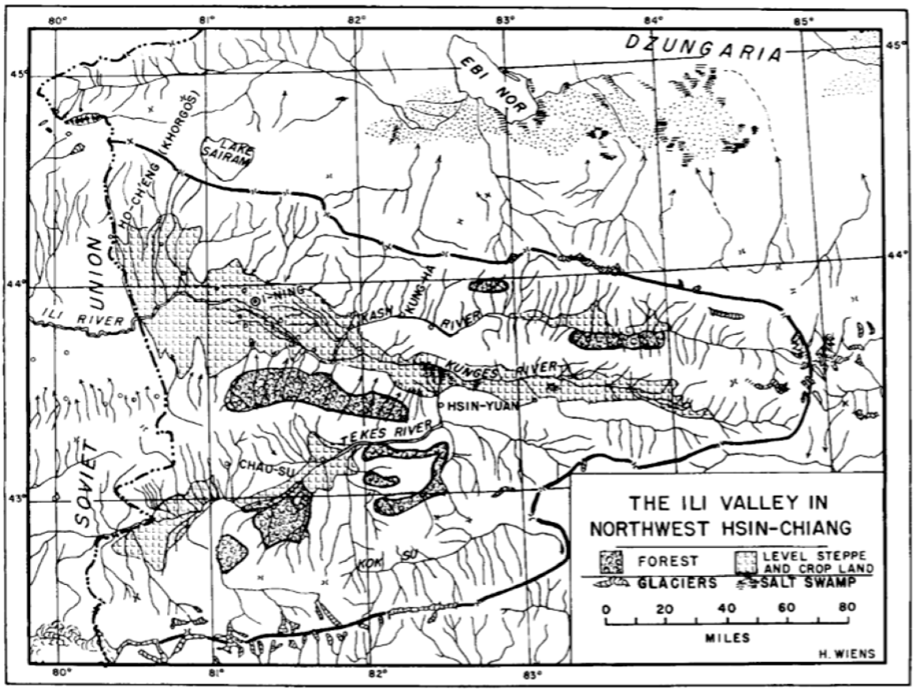
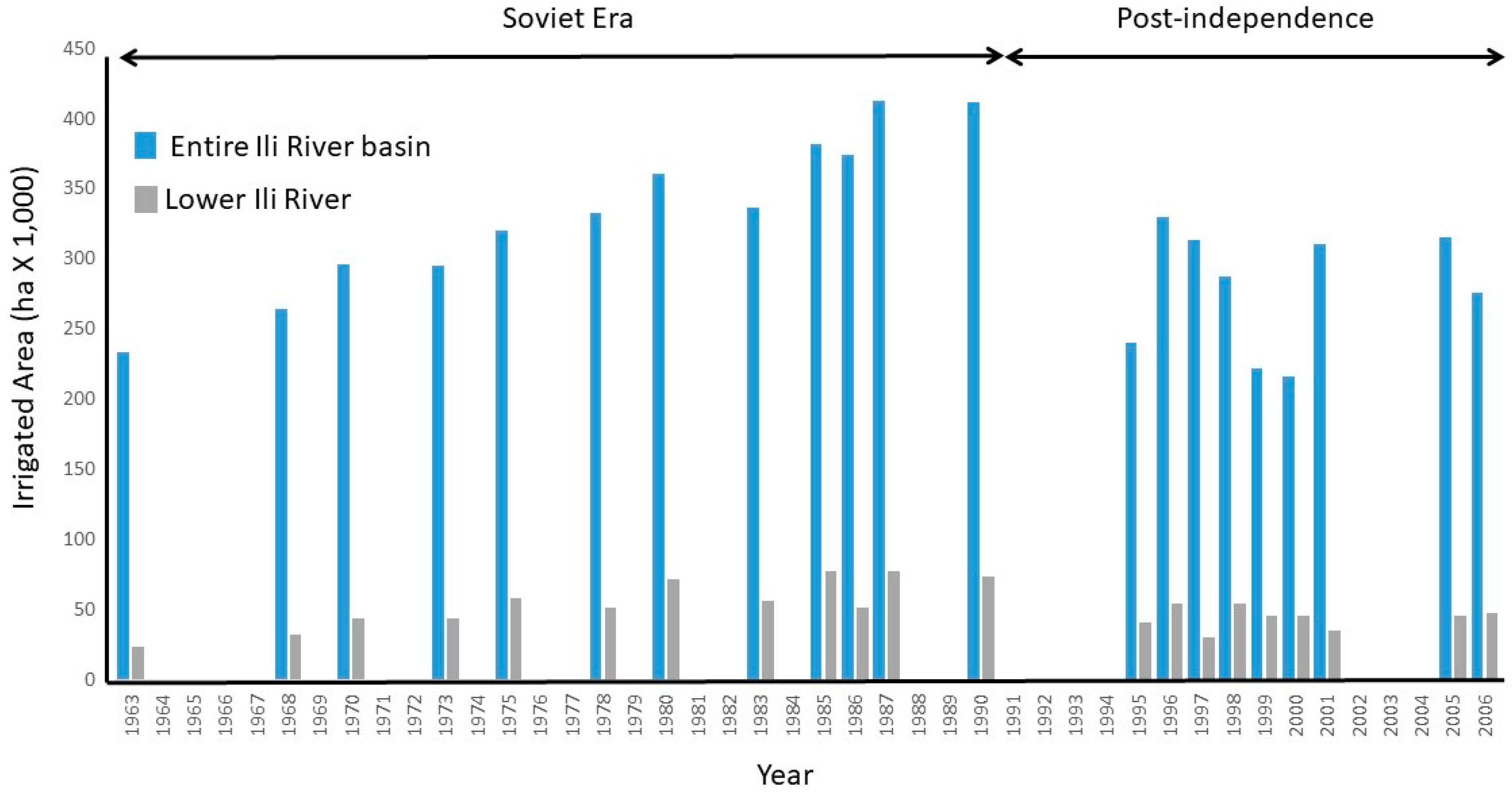
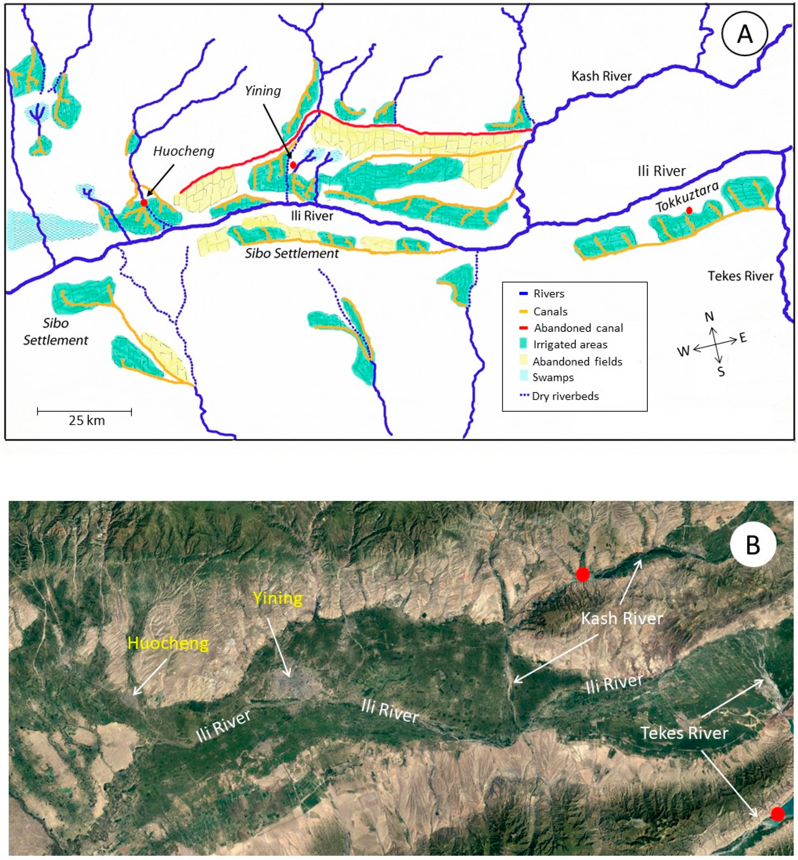
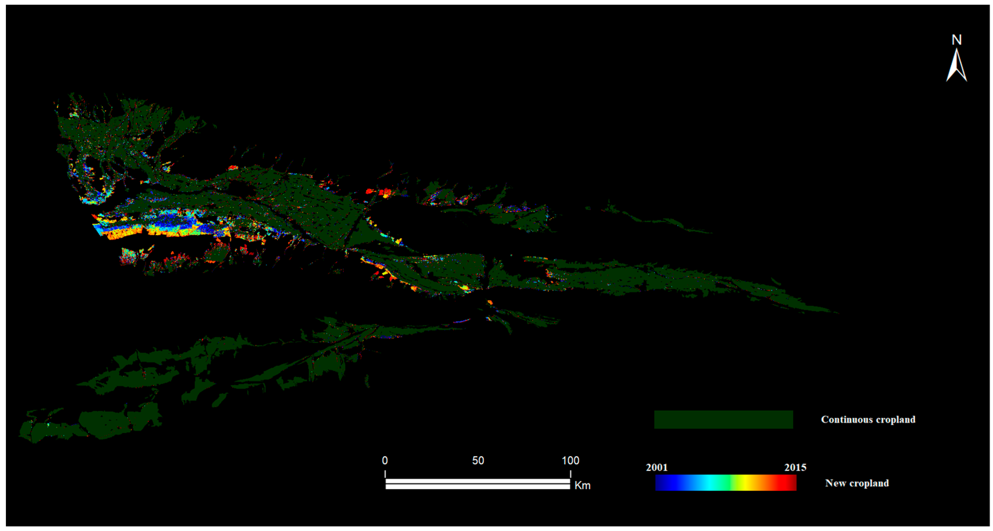
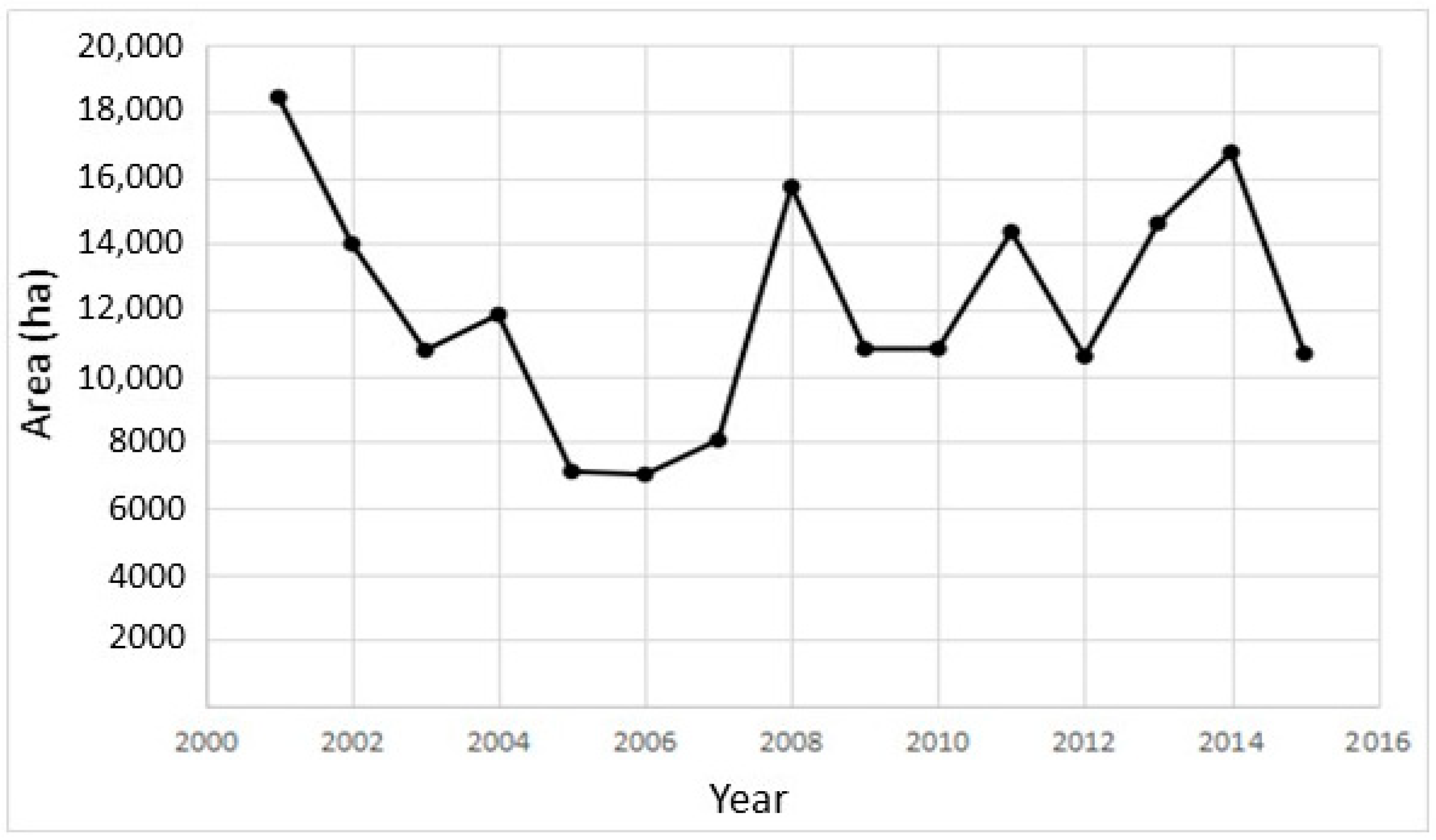
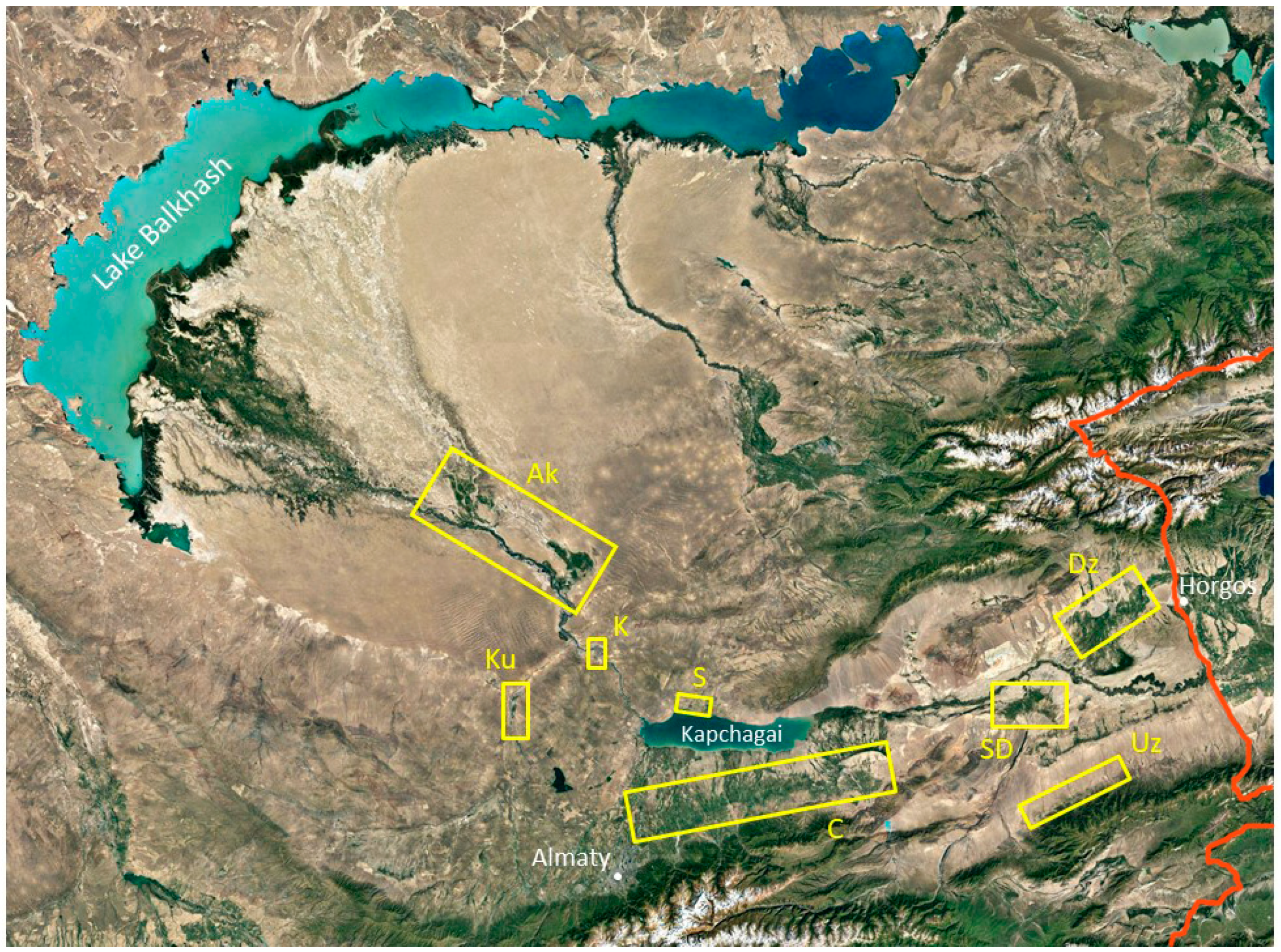
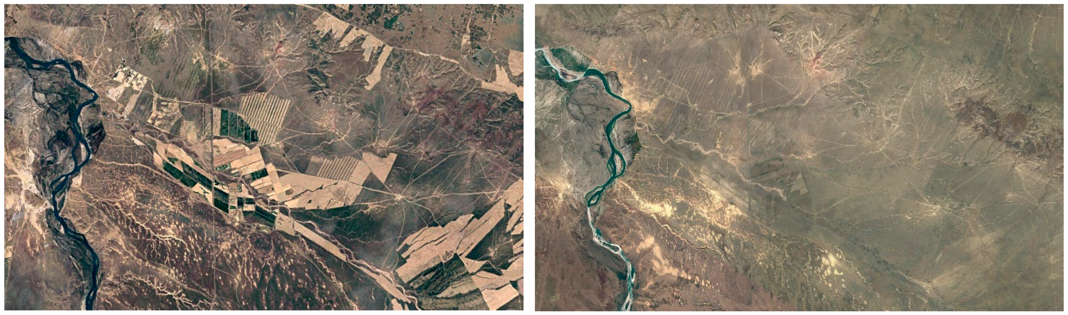
Table 1.
Agricultural crops grown in the upper Ili Valley in the late 18th and early 19th centuries.
Table 1.
Agricultural crops grown in the upper Ili Valley in the late 18th and early 19th centuries.
| Crops | Reference |
|---|---|
| Apples, melons, pears | [7] |
| Apricots, corn, melons, peaches, pears, plums, sorghum, vine crops, watermelons, wheat | [39] |
| Millet and other grains, opium | [8] |
| Grains | [51] |
| Barley, corn, cotton 1, onions, poppies, radishes, rice, rye, scallions, sorghum, tobacco 1, wheat | [11] |
| Barley, cotton, fruit, melons, millet, tobacco, rice, wheat | [52] |
| Barley, cucumbers, eggplants, garlic, millet, onions, poppies, tobacco, tomatoes, wheat | [49] |
| Barley, millet, oats, potatoes, rice, millet | [46] |
Note: 1 These crops were grown mainly by the Sibos; the other crops observed by Radloff [11] were grown mainly by the Solons and Taranchis.
Table 2.
Reservoirs on the Ili River and its major tributaries.
| Location and Description | Dam Coordinates | Construction | Volume (m3 × 106) |
|---|---|---|---|
| Ili River, Kazakhstan | |||
| Kapchagai Reservoir in Almaty Oblast, near Kapchagai 1 | 43°55’19” N, 77°5’51” E | 1969 | 12,000 |
| Kash River, China 2 | |||
| Reservoir in Nilka County, near Dunmazhazan | 43°49’15” N, 81°56’38” E | <1990 | 120–150 |
| Zharyntaysky Reservoir in Nilka County, near Jilintai 3 | 43°51’42” N, 82°50’55” E | 2004 | 650–800 |
| Reservoir in Nilka County, near Jilintai | 43°51’14” N, 82°48’8” E | 2009 | 25–30 |
| Reservoir in Nilka County, near Dunmazhazan | 43°50’11” N, 82°1’11” E | 2010 | 65–70 |
| Tekes River, China 2 | |||
| Kapchagaysky Reservoir in Tekes County, near Ji’ergalangxiang 4 | 43°18’13” N, 82°29’5” E | 2005 | 1650–1800 |
| Reservoir in Gongliu and Xinyuan Counties, near Toudaowancon | 43°23’41” N, 82°29’23” E | 2009 | 25–26 |
| Reservoir in Tekes County, near Kuokesuxiang | 43°6’39” N, 81°53’20” E | 2012 | 55–60 |
| Reservoir in Zhaosu County, near Kaxiajia’erxiang | 42°45’37” N, 81°3’49” E | 2014 | ---- |
Notes: 1 A maximum volume of 16,400 million m3 was achieved during the filling of Kapchagai reservoir in 1980; more recently and for environmental reasons, the level has risen [2]. The figure in the table is a 1987 estimate. 2 Estimated construction dates and volumes for Chinese reservoirs are from [89]. 3 The ultimate capacity of Zharyntaysky reservoir has been reported to be as high as 2530 million m3 [110]. 4 Construction of Kapchagaysky reservoir commenced in 2001 as the main water project of the upper Ili catchment. The reservoir’s planned storage area is 1900 million m3 [43].
Table 3.
Characteristics of irrigation areas in the lower Ili River basin.
| Irrigation Area and Map Coordinates | Irrigated Area 1 (ha) | Water Use 1 (m3/ha/year) | Description |
|---|---|---|---|
| Gravity fed by mountain rivers | |||
| Dzungarian Alatau 44°06′17″ N, 79°55’38″ E | 49,800 | 12,600 | Inflows from the Usek and several smaller streams, north of the Ili River |
| Uzynkara 43°22’29″ N, 79°34’22″ E | 11,800 | 13,100 | Inflows from rivers along the slopes of the Ketmen Range, south of the Ili |
| Chilik River/Trans Ili Alatau 43°31’45″ N, 78°21’56″ E | 152,500 | 10,500 | Bartogai dam and Big Almaty Canal constructed in the 1982–1983, reservoir for irrigation and power |
| Saryn River delta 43°46’54″ N, 79°23’24″ E | 35,200 | 7700 | The river flows from the Ketmen Range, Moinak hydroelectric dam constructed upstream in 2013 |
| Kurty River 43°58’41″ N, 76°19’15″ E | 37,200 | 6100 | Kurty (Kurtinskoe) dam constructed in 1967, for irrigation only |
| Diverted from the Ili River | |||
| Akdala District (2 sites) 44°36’11″ N, 76°47’50″ E 44°56’25″ N, 76°09’32″ E | 25,700 | 29,000 | District has two gravity fed sites in floodplain at Bakanas (1969) and Bakbakhty (1979), designed for rice, remains in operation |
| Shengeldy 43°56’27″ N, 77°28’39″ E | 12,600 | 6200 | North shore of reservoir, established in 1978, nine pumping stations, now mostly abandoned |
| Kerbulak 44°15’18″ N, 76°54’07″ E | 1400 | 6200 | In a flat valley, water pumped from the river for rice and alfalfa, now mostly abandoned |
Note: 1 Data are from 1986, during the last years of the Soviet Union [2].
© 2018 by the authors. Licensee MDPI, Basel, Switzerland. This article is an open access article distributed under the terms and conditions of the Creative Commons Attribution (CC BY) license (http://creativecommons.org/licenses/by/4.0/).
Share and Cite
MDPI and ACS Style
Pueppke, S.G.; Zhang, Q.; Nurtazin, S.T. Irrigation in the Ili River Basin of Central Asia: From Ditches to Dams and Diversion. Water 2018, 10, 1650. https://doi.org/10.3390/w10111650
AMA Style
Pueppke SG, Zhang Q, Nurtazin ST. Irrigation in the Ili River Basin of Central Asia: From Ditches to Dams and Diversion. Water. 2018; 10(11):1650. https://doi.org/10.3390/w10111650
Chicago/Turabian StylePueppke, Steven G., Qingling Zhang, and Sabir T. Nurtazin. 2018. "Irrigation in the Ili River Basin of Central Asia: From Ditches to Dams and Diversion" Water 10, no. 11: 1650. https://doi.org/10.3390/w10111650
Note that from the first issue of 2016, this journal uses article numbers instead of page numbers. See further details here.