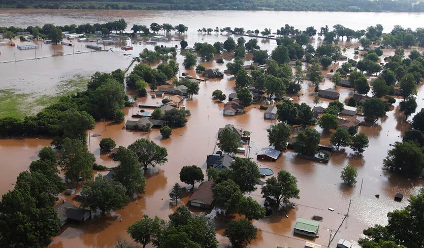
| Above: Homes are flooded on the Arkansas River in Tulsa, Okla., on Friday, May 24, 2019. (Tom Gilbert/Tulsa World via AP). |
Torrential rains in Oklahoma over the past two weeks have brought the Arkansas River in western Arkansas and eastern Oklahoma to its highest water level ever recorded. Near the Oklahoma border at Fort Smith, Arkansas (population 300,000), the river rose to two feet above its previous all-time high on Tuesday morning, and was predicted to rise at least another two feet before cresting on Wednesday. The river also hit a record high on Friday at Ponca City, Oklahoma, about 70 miles upriver from Tulsa. Between those two locations, at Muskogee, Oklahoma, the river crested on Sunday at its second highest level on record. All-time record crests are predicted over the next week along a 100-mile stretch of the river extending from Fort Smith to just upstream from Little Rock, Arkansas. At Little Rock, the crest is predicted to be the sixth highest on record, and the highest since 1990. On Tuesday afternoon, two levees along the Arkansas River in Arkansas were overtopped, flooding farmlands, according to katv.com.
 |
| Figure 1. Top: Observed Oklahoma rainfall (in inches) for the 30-day period ending on May 27, 2019. Over 20” of rain has fallen over northeastern Oklahoma. Bottom: The departure from normal rainfall for the same period; rainfall in northeastern Oklahoma has been more than a foot above average. According to the Oklahoma Climatological Survey, the past month’s rainfall was the heaviest on record for north central, northeast, and west central Oklahoma for the April 28-to-May 27 period—at least 333% of average. Statewide, it has been the second wettest such period on record. Image credit: Oklahoma Climatological Survey. |
Arkansas River flooding has already triggered the evacuation of hundreds of people in Oklahoma, including areas just west of Tulsa. More people are expected to be flooded as water is released from the Keystone Dam in Tulsa, the Tulsa World reported. Engineers are trying to prevent catastrophic flooding that could come if the lake overflows its floodgates. The flood's longevity has also triggered concerns about Tulsa County's 70-year-old levee system, which is undergoing far more prolonged stress than it did during the record-setting floods of 1986.
“This is the culmination of a flood that is now in its fourth week,” David Williams, the U.S. Army Corps of Engineers Tulsa District chief of hydrology and hydraulics engineering, told the newspaper. “I know that it seems like only a weeklong event or so, but we’ve had excessive rainfall in the basin for a month now.”
In the Fort Smith area, the State Highway 59 Bridge was the only crossing on the Arkansas River left open after officials closed the Interstate 540 bridge and the Midland bridge. Schools in Fort Smith will be closed at least through Thursday, the district announced.
 |
| Figure 2. Predicted rainfall amounts for the 3-day period ending at 8 am EDT Friday, May 31, 2019. Rainfall amounts of 3 - 4” are predicted for portions of flood-plagued eastern Oklahoma and western Arkansas. Image credit: NOAA/NWS. |
More rain coming on Wednesday, then drier weather
More heavy rain is expected to fall in Oklahoma this week, with the heaviest rains expected to occur on Wednesday. Rainfall amounts of 3 – 4” are predicted for eastern Oklahoma by Thursday morning, which will aggravate the flooding. Thankfully, a significant shift in the stormy weather pattern is predicted beginning on Friday. Mostly fair weather, due to an upper-level high pressure system, will dominate on Friday and Saturday. More rain is on the way for Sunday and Monday in Oklahoma, with a weak storm system likely to bring another inch or so of rain. However, longer-range ensemble models agree that a stronger ridge of high pressure is likely to camp out over the Midwest U.S. by Tuesday, ushering in an extended period of drier weather to help the region finally dry out.
This is our farm just over the border from Fort Smith, AR in Oklahoma. The silos, feedlot, shops, and farmhand’s house all underwater and still rising. All equipment, animals and people were safely moved out. Total crop loss this year. pic.twitter.com/I3CFtkzTwX
— Duck Farm (@deadmallard) May 28, 2019
Army Corps announces Morganza Spillway expected to open
The U.S. Army Corps of Engineers announced on Monday that they plan to open the Morganza Spillway in Louisiana to control flooding on the Mississippi River by June 2, when the river is predicted to reach its second highest flood crest on record. The spillway has been opened only two other times since it was completed in 1954, during floods in 1973 and 2011. Our Friday post has a detailed look at this rare event, and the history of the spillway.
"The current flood fight is historic and unprecedented," said the Corps, explaining that Monday was the 214th day of their flood fighting efforts on the Mississippi, and that this year’s flood fight "is expected to surpass the 1973 event (225 days) as the longest flood fight."
Downstream from the Morganza Spillway, at Baton Rouge, Louisiana, the Mississippi River rose above flood stage on January 5, and has been in flood ever since—a remarkable stretch of 143 days, breaking the river’s previous longest flood of 135 days set during the great flood of 1927.
 |
| Figure 3. The severe weather outlook for Tuesday, May 28, from NOAA’s Storm Prediction Center (SPC), updated at 12:30 pm EDT. Severe storms, capable of producing large hail, damaging wind and tornadoes are likely this afternoon into tonight from the central Plains eastward to the Midwest. Severe storms with large hail, damaging wind and a couple of tornadoes are also expected across the Upper Ohio Valley and Northeast states this afternoon and evening. |
Moderate Risk of severe weather this afternoon
The Midwest severe weather onslaught that began on May 17 continues today, with NOAA's Storm Prediction Center (SPC) forecasting a "Moderate Risk" of severe weather--their second highest level of concern--over portions of five states. The greatest risk of strong tornadoes will be from northeast Kansas across far northern Missouri.
The last 11 days (May 17-27) have produced a stunning amount of severe weather, including more than 350 preliminary tornado reports. Tornadoes on Monday afternoon and evening were reported from Colorado to Ohio. The most extensive damage was in northern parts of the Dayton area, which was hammered Monday night by a series of tornado-warned storms. Damage was extensive across the northern Dayton suburbs. As of midday Tuesday, EF3 damage had been confirmed by NWS surveys at Trotwood and Beavercreek. About 60 miles to the north-northwest, the small city of Celina was also hard hit; one man died when a car was flung into his home as he slept.
See weather.com for more on Monday's tornadoes in Ohio and elsewhere. We'll have much more on the recent rash of tornadoes in our next post.
Bob Henson contributed to this post.


